FAA INFORMATION EFFECTIVE 20 FEBRUARY 2025
Location
| FAA Identifier: | 0M3 |
| Lat/Long: | 35-32-45.5070N 087-35-50.3680W
35-32.758450N 087-35.839467W
35.5459742,-87.5973244
(estimated) |
| Elevation: | 972 ft. / 296.3 m (surveyed) |
| Variation: | 01W (2000) |
| From city: | 2 miles W of HOHENWALD, TN |
| Time zone: | UTC -6 (UTC -5 during Daylight Saving Time) |
| Zip code: | 38462 |
Airport Operations
| Airport use: | Open to the public |
| Activation date: | 08/1951 |
| Control tower: | no |
| ARTCC: | MEMPHIS CENTER |
| FSS: | JACKSON FLIGHT SERVICE STATION |
| NOTAMs facility: | MKL (NOTAM-D service available) |
| Attendance: | UNATNDD |
| Wind indicator: | lighted |
| Segmented circle: | no |
| Lights: | ACTVT MIRL RWY 02/20 - CTAF. REIL RWY 02 & 20; PAPI RWY 02 & 20 OPR CONSLY. |
| Beacon: | white-green (lighted land airport)
Operates sunset to sunrise. |
Airport Communications
- APCH/DEP SVC PRVDD BY MEMPHIS ARTCC ON FREQS 125.85/379.25 (CENTERVILLE RCAG).
Airport Services
| Fuel available: | 100LL
100LL:FUEL AVBL 24/7 WITH CC. |
| Parking: | tiedowns |
Runway Information
Runway 2/20
| Dimensions: | 4001 x 75 ft. / 1220 x 23 m |
| Surface: | asphalt, in good condition |
| Weight bearing capacity: | | Single wheel: | 8.0 | | Double wheel: | 12.0 |
|
| Runway edge lights: | medium intensity |
| Runway edge markings: | FADED AND PEELING. |
| RUNWAY 2 | | RUNWAY 20 |
| Latitude: | 35-32.444227N | | 35-33.072662N |
| Longitude: | 087-35.961892W | | 087-35.717028W |
| Elevation: | 949.4 ft. | | 967.5 ft. |
| Traffic pattern: | left | | left |
| Runway heading: | 019 magnetic, 018 true | | 199 magnetic, 198 true |
| Displaced threshold: | no | | 492 ft. |
| Markings: | nonprecision, in poor condition | | basic, in poor condition |
| Visual slope indicator: | 2-light PAPI on left (3.00 degrees glide path) | | 2-light PAPI on left (3.00 degrees glide path) |
| Runway end identifier lights: | yes | | yes |
| Touchdown point: | yes, no lights | | yes, no lights |
| Obstructions: | 78 ft. trees, 1620 ft. from runway, 358 ft. right of centerline, 18:1 slope to clear | | 70 ft. trees, 938 ft. from runway, 74 ft. right of centerline, 10:1 slope to clear
APCH RATIO 20:1 TO DTHR. |
Airport Ownership and Management from official FAA records
| Ownership: | Publicly-owned |
| Owner: | LEWIS COUNTY
COUNTY COURTHOUSE
HOHENWALD, TN 38462
Phone 931-796-3378 |
| Manager: | GARY NASH
1180 W MAIN ST
HOHENWALD, TN 38462
Phone 931-796-3448 |
Additional Remarks
| - | FOR CD CTC MEMPHIS ARTCC AT 901-368-8453/8449. |
Instrument Procedures
NOTE: All procedures below are presented as PDF files. If you need a reader for these files, you should download the free Adobe Reader.NOT FOR NAVIGATION. Please procure official charts for flight.
FAA instrument procedures published for use from 20 February 2025 at 0901Z to 20 March 2025 at 0900Z.
IAPs - Instrument Approach Procedures |
|---|
| RNAV (GPS) RWY 02 | |
download (204KB) |
| NOTE: Special Take-Off Minimums/Departure Procedures apply | |
download (366KB) |
Other nearby airports with instrument procedures:
KGHM - Centerville Municipal Airport (19 nm NE)
KMRC - Maury County Regional Airport (20 nm E)
2M2 - Lawrenceburg/Lawrence County Airport (Fleeman Field) (25 nm SE)
KPVE - Beech River Regional Airport (30 nm W)
0M5 - Humphreys County Airport (35 nm N)
|
|

Road maps at:
MapQuest
Bing
Google
| Aerial photo |
|---|
WARNING: Photo may not be current or correct
 Taken in 2005
Do you have a better or more recent aerial photo of Paul Bridges Field Airport that you would like to share? If so, please send us your photo.
|
| Sectional chart |
|---|
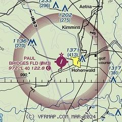
|
| Airport distance calculator |
|---|
|
|
| Sunrise and sunset |
|---|
|
Times for 13-Mar-2025
| | Local
(UTC-6) | | Zulu
(UTC) |
|---|
| Morning civil twilight | | 05:40 | | 11:40 |
| Sunrise | | 06:05 | | 12:05 |
| Sunset | | 17:55 | | 23:55 |
| Evening civil twilight | | 18:20 | | 00:20 |
|
| Current date and time |
|---|
| Zulu (UTC) | 14-Mar-2025 02:54:37 |
|---|
| Local (UTC-6) | 13-Mar-2025 20:54:37 |
|---|
|
| METAR |
|---|
KMRC
20nm E | 140210Z AUTO 00000KT 10SM CLR 17/10 A2985 RMK A01
|
K2M2
25nm SE | 140215Z AUTO VRB03KT 10SM FEW037 SCT060 BKN075 16/11 A2987 RMK A01
|
KPVE
30nm W | 140215Z AUTO 13004KT 10SM CLR 17/11 A2984 RMK A01
|
KGZS
35nm SE | 140215Z AUTO 00000KT 10SM SCT070 BKN085 12/12 A2988 RMK A01
|
KM02
36nm N | 140215Z AUTO 20009KT 10SM FEW050 FEW060 SCT070 18/09 A2984 RMK A01
|
KSNH
38nm SW | 140210Z AUTO 14004KT 10SM SCT039 BKN048 BKN060 16/16 A2982 RMK A01
|
KLUG
39nm E | 140215Z AUTO 19005KT 10SM CLR 15/11 A2987 RMK A01
|
|
| NOTAMs |
|---|
NOTAMs are issued by the DoD/FAA and will open in a separate window not controlled by AirNav.
|
|


