FAA INFORMATION EFFECTIVE 20 FEBRUARY 2025
Location
| FAA Identifier: | 12D |
| Lat/Long: | 47-49-05.3600N 092-17-09.8400W
47-49.089333N 092-17.164000W
47.8181556,-92.2860667
(estimated) |
| Elevation: | 1369.9 ft. / 417.5 m (surveyed) |
| Variation: | 01W (2010) |
| From city: | 1 mile NW of TOWER, MN |
| Time zone: | UTC -6 (UTC -5 during Daylight Saving Time) |
| Zip code: | 55790 |
Airport Operations
| Airport use: | Open to the public |
| Activation date: | 12/1959 |
| Control tower: | no |
| ARTCC: | MINNEAPOLIS CENTER |
| FSS: | PRINCETON FLIGHT SERVICE STATION |
| NOTAMs facility: | PNM (NOTAM-D service available) |
| Attendance: | UNATNDD |
| Wind indicator: | lighted |
| Segmented circle: | no |
| Lights: | ACTVT OR INCR INTST PAPI RWY 08 & 26; MIRL RWY 08/26 - CTAF. MIRL RWY 08/26 PRESET MED INTST. |
Airport Communications
| CTAF: | 122.9 |
| WX AWOS-3 at CQM (16 nm W): | 118.175 (218-666-2539) |
| WX AWOS-3PT at ELO (18 nm E): | 132.025 (218-365-3814) |
- APCH/DEP SVC PRVDD BY MINNEAPOLIS ARTCC ON 127.9/281.45 (DULUTH RCAG).
Nearby radio navigation aids
| VOR radial/distance | | VOR name | | Freq | | Var |
|---|
| HIBr027/35.3 | | HIBBING VOR/DME | | 116.55 | | 02E |
| NDB name | | Hdg/Dist | | Freq | | Var | | ID |
|---|
| SCOTT | | 165/27.6 | | 385 | | 01W | | SCG | ... -.-. --. |
Airport Services
| Fuel available: | 100LL
100LL:FUEL AVBL H24 SELF SVC VIA CREDIT CARD. |
| Parking: | tiedowns |
Runway Information
Runway 8/26
| Dimensions: | 3400 x 75 ft. / 1036 x 23 m |
| Surface: | asphalt, in good condition |
| Runway edge lights: | medium intensity |
| RUNWAY 8 | | RUNWAY 26 |
| Latitude: | 47-49.075667N | | 47-49.103000N |
| Longitude: | 092-17.578667W | | 092-16.749333W |
| Elevation: | 1365.8 ft. | | 1369.9 ft. |
| Traffic pattern: | left | | right |
| Runway heading: | 088 magnetic, 087 true | | 268 magnetic, 267 true |
| Markings: | nonprecision, in fair condition | | nonprecision, in fair condition |
| Visual slope indicator: | 2-light PAPI on left (3.00 degrees glide path) | | 2-light PAPI on left (3.50 degrees glide path)
UNUSBL BYD 4 DEGS LEFT OF CNTRLN. |
| Touchdown point: | yes, no lights | | yes, no lights |
| Obstructions: | none | | 22 ft. brush, 354 ft. from runway, 131 ft. left of centerline, 7:1 slope to clear
6 FT BRUSH, 22 FT DIST, 215 FT L. |
Runway 14W/32W
| Dimensions: | 5000 x 200 ft. / 1524 x 61 m |
| Surface: | water |
| RUNWAY 14W | | RUNWAY 32W |
| Traffic pattern: | left | | left |
Airport Ownership and Management from official FAA records
| Ownership: | Publicly-owned |
| Owner: | CITY OF TOWER
PO BOX 576, 602 MAIN ST
TOWER, MN 55790-0576
Phone 218-753-4070 |
| Manager: | JOHN BURGESS
PO BOX 576, 602 MAIN ST
TOWER, MN 55790-0576
Phone 218-780-5902 |
Additional Remarks
| - | 270 FT HILL, 2500 FT SOUTHEAST OF ARPT. |
| - | ULTRALIGHT TFC ON & INVOF ARPT. |
| - | FOR CD CTC MINNEAPOLIS ARTCC AT 651-463-5588. |
| - | COLD TEMPERATURE AIRPORT. ALTITUDE CORRECTION REQUIRED AT OR BELOW -35C. |
Instrument Procedures
NOTE: All procedures below are presented as PDF files. If you need a reader for these files, you should download the free Adobe Reader.NOT FOR NAVIGATION. Please procure official charts for flight.
FAA instrument procedures published for use from 20 February 2025 at 0901Z to 20 March 2025 at 0900Z.
IAPs - Instrument Approach Procedures |
|---|
| RNAV (GPS) RWY 08 | |
download (190KB) |
| RNAV (GPS) RWY 26 | |
download (185KB) |
| NOTE: Special Take-Off Minimums/Departure Procedures apply | |
download (156KB) |
Other nearby airports with instrument procedures:
KCQM - Cook Municipal Airport (16 nm W)
KELO - Ely Municipal Airport (18 nm E)
KEVM - Eveleth/Virginia Municipal Airport (25 nm S)
KORB - Orr Regional Airport (26 nm NW)
KHIB - Range Regional Airport (34 nm SW)
|
|

Road maps at:
MapQuest
Bing
Google
| Aerial photo |
|---|
WARNING: Photo may not be current or correct

Do you have a better or more recent aerial photo of Tower Municipal Airport that you would like to share? If so, please send us your photo.
|
| Sectional chart |
|---|
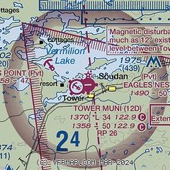
|
| Airport distance calculator |
|---|
|
|
| Sunrise and sunset |
|---|
|
Times for 09-Mar-2025
| | Local
(UTC-6) | | Zulu
(UTC) |
|---|
| Morning civil twilight | | 06:04 | | 12:04 |
| Sunrise | | 06:35 | | 12:35 |
| Sunset | | 18:04 | | 00:04 |
| Evening civil twilight | | 18:35 | | 00:35 |
|
| Current date and time |
|---|
| Zulu (UTC) | 10-Mar-2025 04:23:01 |
|---|
| Local (UTC-6) | 09-Mar-2025 22:23:01 |
|---|
|
| METAR |
|---|
KCQM
16nm W | 100355Z AUTO 00000KT 10SM OVC100 M01/M05 A2972 RMK AO2
|
KELO
19nm E | 100355Z AUTO 00000KT 10SM M01/M06 A2971 RMK AO2
|
KORB
26nm NW | 100355Z AUTO 00000KT 10SM BKN110 M01/M03 A2970 RMK AO2
|
KEVM
27nm S | 100355Z AUTO 00000KT 10SM CLR M01/M04 A2972 RMK AO2 T10091041
|
KCDD
29nm NW | 091935Z AUTO 34007KT 10SM CLR 12/M03 A2968 RMK AO2
|
|
| TAF |
|---|
KHIB
34nm SW | 091730Z 0918/1018 27008G16KT P6SM FEW240 TEMPO 0918/0921 29011G20KT FM092300 29007KT P6SM SCT200 FM100800 00000KT P6SM BKN130 WS020/26030KT FM101200 19006KT P6SM BKN180 FM101500 18007G15KT P6SM BKN190
|
|
| NOTAMs |
|---|
NOTAMs are issued by the DoD/FAA and will open in a separate window not controlled by AirNav.
|
|


