FAA INFORMATION EFFECTIVE 23 JANUARY 2025
Location
| FAA Identifier: | 18A |
| Lat/Long: | 34-20-25.3000N 083-07-50.9000W
34-20.421667N 083-07.848333W
34.3403611,-83.1308056
(estimated) |
| Elevation: | 889.9 ft. / 271 m (estimated) |
| Variation: | 05W (2005) |
| From city: | 1 mile SW of CANON, GA |
| Time zone: | UTC -5 (UTC -4 during Daylight Saving Time) |
| Zip code: | 30520 |
Airport Operations
| Airport use: | Open to the public |
| Activation date: | 11/1970 |
| Control tower: | no |
| ARTCC: | ATLANTA CENTER |
| FSS: | MACON FLIGHT SERVICE STATION |
| NOTAMs facility: | MCN (NOTAM-D service available) |
| Attendance: | UNATNDD |
| Wind indicator: | lighted |
| Segmented circle: | yes |
| Lights: | DUSK-0000. AFT 0000, ACTVT PAPI RWY 08 & 26; MIRL RWY 08/26 - CTAF. |
| Beacon: | white-green (lighted land airport)
Operates sunset to sunrise. |
Airport Communications
| CTAF: | 122.9 |
| WX AWOS-3PT: | 118.625 (706-245-1097) |
| WX AWOS-3 at TOC (17 nm NW): | 119.625 (706-297-7473) |
- APCH/DEP SVC PRVDD BY ATLANTA ARTCC ON FREQS 127.5/316.05 (ATHENS RCAG).
Nearby radio navigation aids
| VOR radial/distance | | VOR name | | Freq | | Var |
|---|
| ELWr255/17.8 | | ELECTRIC CITY VORTAC | | 108.60 | | 00E |
| ODFr159/22.9 | | FOOTHILLS VOR/DME | | 113.40 | | 00E |
| AHNr022/25.5 | | ATHENS VOR/DME | | 116.95 | | 00E |
| NDB name | | Hdg/Dist | | Freq | | Var | | ID |
|---|
| BARROW COUNTY | | 048/33.3 | | 404 | | 05W | | BMW | -... -- .-- |
Airport Services
| Fuel available: | 100LL JET-A
100LL:SELF SVC 100LL AND A FUEL AVBL 24 HRS WITH CREDIT CARD. |
| Parking: | tiedowns |
| Airframe service: | NONE |
| Powerplant service: | NONE |
| Bottled oxygen: | NONE |
| Bulk oxygen: | NONE |
Runway Information
Runway 8/26
| Dimensions: | 5000 x 75 ft. / 1524 x 23 m |
| Surface: | asphalt, in good condition |
| Weight bearing capacity: | |
| Runway edge lights: | medium intensity |
| RUNWAY 8 | | RUNWAY 26 |
| Latitude: | 34-20.294337N | | 34-20.547428N |
| Longitude: | 083-08.321550W | | 083-07.375757W |
| Elevation: | 828.5 ft. | | 889.9 ft. |
| Traffic pattern: | left | | left |
| Runway heading: | 077 magnetic, 072 true | | 257 magnetic, 252 true |
| Markings: | nonprecision, in fair condition | | nonprecision, in fair condition |
| Visual slope indicator: | 2-light PAPI on left (3.00 degrees glide path) | | 2-light PAPI on left (3.00 degrees glide path) |
| Touchdown point: | yes, no lights | | yes, no lights |
| Obstructions: | 42 ft. trees, 578 ft. from runway, 294 ft. left of centerline, 9:1 slope to clear | | 84 ft. trees, 1796 ft. from runway, 351 ft. left of centerline, 19:1 slope to clear |
Airport Ownership and Management from official FAA records
| Ownership: | Publicly-owned |
| Owner: | FRANKLIN COUNTY
823 AIRPORT ROAD
CANON, GA 30520
Phone 706-244-0383
FRANKLIN-HART AIRPORT AUTHORITY. |
| Manager: | MARK BROWN
823 AIRPORT ROAD
CANON, GA 30520
Phone 706-244-0383
ARPT PHONE 706-245-1002. |
Additional Remarks
| - | FOR CD CTC ATLANTA ARTCC AT 770-210-7692. |
Instrument Procedures
NOTE: All procedures below are presented as PDF files. If you need a reader for these files, you should download the free Adobe Reader.NOT FOR NAVIGATION. Please procure official charts for flight.
FAA instrument procedures published for use from 23 January 2025 at 0901Z to 20 February 2025 at 0900z.
IAPs - Instrument Approach Procedures |
|---|
| RNAV (GPS) RWY 08 | |
download (216KB) |
| RNAV (GPS) RWY 26 | |
download (213KB) |
| NOTE: Special Alternate Minimums apply | |
download (153KB) |
| NOTE: Special Take-Off Minimums/Departure Procedures apply | |
download (508KB) |
Other nearby airports with instrument procedures:
KTOC - Toccoa Airport-RG Letourneau Field (17 nm NW)
KEBA - Elbert County Airport-Patz Field (21 nm SE)
KAND - Anderson Regional Airport (23 nm NE)
KAJR - Habersham County Airport (23 nm NW)
KCEU - Oconee County Regional Airport (23 nm NE)
|
|

Road maps at:
MapQuest
Bing
Google
| Aerial photo |
|---|
WARNING: Photo may not be current or correct
 Taken in May 2009
Do you have a better or more recent aerial photo of Franklin-Hart Airport that you would like to share? If so, please send us your photo.
|
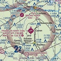
| Sectional chart |
|---|
|
| Airport distance calculator |
|---|
|
|
| Sunrise and sunset |
|---|
|
Times for 05-Feb-2025
| | Local
(UTC-5) | | Zulu
(UTC) |
|---|
| Morning civil twilight | | 07:02 | | 12:02 |
| Sunrise | | 07:28 | | 12:28 |
| Sunset | | 18:05 | | 23:05 |
| Evening civil twilight | | 18:31 | | 23:31 |
|
| Current date and time |
|---|
| Zulu (UTC) | 05-Feb-2025 23:27:58 |
|---|
| Local (UTC-5) | 05-Feb-2025 18:27:58 |
|---|
|
| METAR |
|---|
| K18A | 052255Z AUTO 11005KT 10SM CLR 19/09 A3012 RMK AO2 T01890093
|
KTOC
17nm NW | 052255Z AUTO 10004KT 10SM SCT120 18/09 A3012 RMK AO2 T01760086
|
|
| TAF |
|---|
KAND
23nm NE | 051739Z 0518/0618 09008KT P6SM SCT050 FM060300 08005KT P6SM OVC022 PROB30 0603/0609 4SM -RA BR OVC015 FM060900 07003KT P6SM OVC007 FM061100 00000KT 5SM BR OVC005 FM061700 23009KT P6SM BKN012
|
KAHN
25nm SW | 051728Z 0518/0618 04004KT P6SM SCT025 BKN035 FM051900 09005KT P6SM VCSH BKN025 FM052300 09004KT P6SM -SHRA SCT015 BKN020 FM060300 09004KT 6SM BR OVC008 FM060700 10003KT 4SM BR OVC004 FM061400 VRB03KT P6SM SCT003 SCT015
|
|
| NOTAMs |
|---|
NOTAMs are issued by the DoD/FAA and will open in a separate window not controlled by AirNav.
|
|


