FAA INFORMATION EFFECTIVE 20 FEBRUARY 2025
Location
| FAA Identifier: | 1K8 |
| Lat/Long: | 36-32-46.9000N 095-00-48.7000W
36-32.781667N 095-00.811667W
36.5463611,-95.0135278
(estimated) |
| Elevation: | 782.7 ft. / 238.6 m (surveyed) |
| Variation: | 02E (2020) |
| From city: | 1 mile NE of KETCHUM, OK |
| Time zone: | UTC -6 (UTC -5 during Daylight Saving Time) |
| Zip code: | 74301 |
Airport Operations
| Airport use: | Open to the public |
| Activation date: | 12/1987 |
| Control tower: | no |
| ARTCC: | KANSAS CITY CENTER |
| FSS: | MC ALESTER FLIGHT SERVICE STATION |
| NOTAMs facility: | MLC (NOTAM-D service available) |
| Attendance: | THUR-MON 0900 - 1700, ALL SUN-WED IRREG
SVC AFT HR - 918-629-3913. |
| Wind indicator: | lighted |
| Segmented circle: | no |
| Lights: | ACTVT MIRL RWY 18/36 - CTAF. PAPI RWY 18 & 36 ON CONSLY. |
Airport Communications
| CTAF: | 122.9 |
| WX AWOS-3PT: | 118.150 (918-782-2047) |
| WX AWOS-3PT at GMJ (14 nm E): | 119.025 (918-786-8350) |
- APCH/DEP CTL SVC PRVDD BY KANSAS CITY ARTCC (ZKC) ON 128.6/282.325 (EDNA RCAG).
Nearby radio navigation aids
| NDB name | | Hdg/Dist | | Freq | | Var | | ID |
|---|
| SILOAM SPRINGS | | 306/33.2 | | 284 | | 04E | | SLG | ... .-.. --. |
Airport Services
| Fuel available: | 100LL JET-A |
| Parking: | hangars and tiedowns |
| Airframe service: | MINOR |
| Powerplant service: | MINOR |
Runway Information
Runway 18/36
| Dimensions: | 4730 x 75 ft. / 1442 x 23 m |
| Surface: | asphalt, in good condition |
| Weight bearing capacity: | | Single wheel: | 30.0 | | Double wheel: | 60.0 |
|
| Runway edge lights: | medium intensity |
| RUNWAY 18 | | RUNWAY 36 |
| Latitude: | 36-33.170903N | | 36-32.391397N |
| Longitude: | 095-00.808582W | | 095-00.813905W |
| Elevation: | 782.6 ft. | | 781.3 ft. |
| Traffic pattern: | left | | left |
| Runway heading: | 178 magnetic, 180 true | | 358 magnetic, 360 true |
| Displaced threshold: | 442 ft. | | 432 ft. |
| Declared distances: | TORA:4299 TODA:4299 ASDA:4670 LDA:4228 | | TORA:4287 TODA:4287 ASDA:4670 LDA:4238 |
| Markings: | nonprecision, in good condition | | nonprecision, in good condition |
| Visual slope indicator: | 4-light PAPI on left (4.00 degrees glide path) | | 4-light PAPI on left (3.00 degrees glide path) |
| Touchdown point: | yes, no lights | | yes, no lights |
| Obstructions: | 15 ft. road, 265 ft. from runway, 4:1 slope to clear | | 15 ft. road, 270 ft. from runway, 4:1 slope to clear |
Airport Ownership and Management from official FAA records
| Ownership: | Publicly-owned |
| Owner: | TOWN OF KETCHUM
124 BROADWAY
KETCHUM, OK 74349
Phone 918-782-2244 |
| Manager: | JIM BROWN
P.O. BOX 928, RT 3 BOX 1557
KETCHUM, OK 74349
Phone 937-623-0039 |
Additional Remarks
| - | FOR CD CTC KANSAS CITY ARTCC AT 913-254-8508. |
| - | SELF SVC FUEL H24 WITH CREDIT CARD. |
Instrument Procedures
NOTE: All procedures below are presented as PDF files. If you need a reader for these files, you should download the free Adobe Reader.NOT FOR NAVIGATION. Please procure official charts for flight.
FAA instrument procedures published for use from 20 February 2025 at 0901Z to 20 March 2025 at 0900Z.
IAPs - Instrument Approach Procedures |
|---|
| RNAV (GPS) RWY 18 | |
download (203KB) |
| RNAV (GPS) RWY 36 | |
download (218KB) |
| NOTE: Special Take-Off Minimums/Departure Procedures apply | |
download (202KB) |
Other nearby airports with instrument procedures:
H04 - Vinita Municipal Airport (8 nm NW)
KGMJ - Grove Regional Airport (14 nm E)
KMIO - Miami Regional Airport (23 nm N)
H71 - Mid-America Industrial Airport (25 nm SW)
KGCM - Claremore Regional Airport (27 nm SW)
|
|

Road maps at:
MapQuest
Bing
Google
| Aerial photo |
|---|
WARNING: Photo may not be current or correct
 Photo taken 29-Jan-2019
looking north.
Photo taken 29-Jan-2019
looking north.
Do you have a better or more recent aerial photo of South Grand Lake Regional Airport that you would like to share? If so, please send us your photo.
|
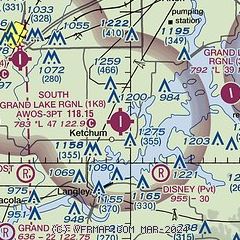
| Sectional chart |
|---|
|
| Airport distance calculator |
|---|
|
|
| Sunrise and sunset |
|---|
|
Times for 10-Mar-2025
| | Local
(UTC-6) | | Zulu
(UTC) |
|---|
| Morning civil twilight | | 06:13 | | 12:13 |
| Sunrise | | 06:39 | | 12:39 |
| Sunset | | 18:22 | | 00:22 |
| Evening civil twilight | | 18:47 | | 00:47 |
|
| Current date and time |
|---|
| Zulu (UTC) | 11-Mar-2025 00:31:18 |
|---|
| Local (UTC-6) | 10-Mar-2025 18:31:18 |
|---|
|
| METAR |
|---|
KGMJ
14nm E | 110015Z AUTO 19008KT 10SM CLR 20/M00 A2985 RMK AO2 TSNO
|
KGCM
27nm SW | 110015Z AUTO 20009KT 10SM CLR 20/02 A2984 RMK AO2
|
|
| TAF |
|---|
KXNA
38nm SE | 101720Z 1018/1118 23011KT P6SM SKC FM110000 20007KT P6SM SKC FM111500 20013G23KT P6SM SKC
|
KJLN
44nm NE | 101720Z 1018/1118 22012G20KT P6SM SKC FM110100 20012G22KT P6SM SKC FM110600 20013G24KT P6SM SKC WS020/24040KT
|
KROG
46nm E | 101720Z 1018/1118 23011KT P6SM SKC FM110000 19008KT P6SM SKC FM111500 21013G23KT P6SM SKC
|
KTUL
47nm SW | 101720Z 1018/1118 20011G20KT P6SM SKC FM110000 18011KT P6SM SKC FM111600 19011G20KT P6SM SKC
|
|
| NOTAMs |
|---|
NOTAMs are issued by the DoD/FAA and will open in a separate window not controlled by AirNav.
|
|


