FAA INFORMATION EFFECTIVE 17 APRIL 2025
Location
| FAA Identifier: | 1N7 |
| Lat/Long: | 40-58-16.0793N 074-59-51.0146W
40-58.267988N 074-59.850243W
40.9711331,-74.9975041
(estimated) |
| Elevation: | 371.5 ft. / 113.2 m (surveyed) |
| Variation: | 13W (1995) |
| From city: | 2 miles SW of BLAIRSTOWN, NJ |
| Time zone: | UTC -4 (UTC -5 during Standard Time) |
| Zip code: | 07825 |
Airport Operations
| Airport use: | Open to the public |
| Activation date: | 10/1941 |
| Control tower: | no |
| ARTCC: | NEW YORK CENTER |
| FSS: | MILLVILLE FLIGHT SERVICE STATION |
| NOTAMs facility: | MIV (NOTAM-D service available) |
| Attendance: | 0700-1800 |
| Wind indicator: | lighted |
| Segmented circle: | no |
| Lights: | ACTVT MIRL RY 07/25-CTAF. |
| Beacon: | white-green (lighted land airport)
Operates sunset to sunrise. |
Airport Communications
| CTAF/UNICOM: | 123.0 |
| NEWARK APPROACH: | 124.45 ;FROM WEST 127.6 ;FROM EAST |
| NEWARK DEPARTURE: | 124.45 ;FROM WEST 127.6 ;FROM EAST |
| IC: | 127.6 ;FROM EAST |
| WX ASOS at 12N (12 nm E): | PHONE 609-325-2295 |
| WX ASOS at MPO (20 nm NW): | 120.275 (570-839-1584) |
- NEWARK APCH CTL PRVDS RADAR APCH/DEP SVC FROM EAST; ALLENTOWN APCH CTL PRVDS RADAR APCH/DEP SVC FROM WEST.
Nearby radio navigation aids
| VOR radial/distance | | VOR name | | Freq | | Var |
|---|
| STWr267/6.0 | | STILLWATER VOR/DME | | 109.60 | | 11W |
| BWZr333/13.1 | | BROADWAY VOR/DME | | 114.20 | | 11W |
| SAXr265/21.6 | | SPARTA VORTAC | | 115.70 | | 11W |
| FJCr065/25.4 | | ALLENTOWN VORTAC | | 117.50 | | 10W |
| SBJr343/26.0 | | SOLBERG VOR/DME | | 112.90 | | 10W |
| HUOr226/32.1 | | HUGUENOT VOR/DME | | 116.10 | | 11W |
| LVZr130/36.1 | | WILKES-BARRE VORTAC | | 111.60 | | 10W |
| ETXr062/39.0 | | EAST TEXAS VOR/DME | | 110.20 | | 09W |
Airport Services
| Fuel available: | 100LL
100LL:24 HOUR SELF SERVICE |
| Parking: | tiedowns |
| Airframe service: | MAJOR |
| Powerplant service: | MAJOR |
| Bottled oxygen: | NONE |
| Bulk oxygen: | LOW |
Runway Information
Runway 7/25
| Dimensions: | 3112 x 70 ft. / 949 x 21 m |
| Surface: | asphalt, in excellent condition |
| Runway edge lights: | medium intensity |
| RUNWAY 7 | | RUNWAY 25 |
| Latitude: | 40-58.142872N | | 40-58.393105N |
| Longitude: | 075-00.145260W | | 074-59.555258W |
| Elevation: | 366.2 ft. | | 371.5 ft. |
| Traffic pattern: | left | | left |
| Runway heading: | 074 magnetic, 061 true | | 254 magnetic, 241 true |
| Displaced threshold: | 318 ft. | | 235 ft. |
| Markings: | nonprecision, in good condition | | nonprecision, in good condition |
| Runway end identifier lights: | no | | no |
| Touchdown point: | yes, no lights | | yes, no lights |
| Obstructions: | 77 ft. trees, 225 ft. from runway, 198 ft. right of centerline
+95 FT TREE, 4 FT FROM RY END, 225 FT L | | 25 ft. trees, 207 ft. from runway, 31 ft. right of centerline
+33FT TREE, 23 FT FM RWY END, 145 FT R |
Airport Ownership and Management from official FAA records
| Ownership: | Privately-owned |
| Owner: | J.D. AIR INC.
17-68 RIVER ROAD
FAIRLAWN, NJ 07410
Phone 201-796-1556 |
| Manager: | DENNIS KIERNAN
36 LAMBERT RD.
BLAIRSTOWN, NJ 07825
Phone 908-362-8965 |
Additional Remarks
| - | GLIDERS & TOW AIRPLANES OPERATE FM TURF AREA JUST SOUTH OF RY 07/25. |
| - | TREES IN THE 7:1 TRANSITIONAL AREA ALONG RUNWAY SIDES. |
| - | HILL EAST OF ARPT MAY REQUIRE PILOTS TO EXECUTE STEEP APCH TO RY 25. |
| - | FOR CD CTC ALLENTOWN APCH AT 800-728-6322. |
Instrument Procedures
NOTE: All procedures below are presented as PDF files. If you need a reader for these files, you should download the free Adobe Reader.NOT FOR NAVIGATION. Please procure official charts for flight.
FAA instrument procedures published for use from 17 April 2025 at 0901Z to 15 May 2025 at 0900z.
IAPs - Instrument Approach Procedures |
|---|
| RNAV (GPS) RWY 07 | |
download (202KB) |
| RNAV (GPS) RWY 25 **CHANGED** | |
download (203KB) |
| NOTE: Special Take-Off Minimums/Departure Procedures apply | |
download (150KB) |
Other nearby airports with instrument procedures:
12N - Aeroflex/Andover Airport (12 nm E)
N43 - Braden Airpark (18 nm SW)
KMPO - Pocono Mountains Regional Airport (20 nm NW)
KFWN - Sussex Airport (22 nm NE)
N85 - Alexandria Airport (23 nm S)
|
|

Road maps at:
MapQuest
Bing
Google
| Aerial photo |
|---|
WARNING: Photo may not be current or correct
 Photo taken 06-Sep-2013
looking north.
Photo taken 06-Sep-2013
looking north.
Do you have a better or more recent aerial photo of Blairstown Airport that you would like to share? If so, please send us your photo.
|
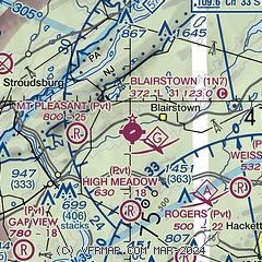
| Sectional chart |
|---|
|
| Airport distance calculator |
|---|
|
|
| Sunrise and sunset |
|---|
|
Times for 01-May-2025
| | Local
(UTC-4) | | Zulu
(UTC) |
|---|
| Morning civil twilight | | 05:29 | | 09:29 |
| Sunrise | | 05:59 | | 09:59 |
| Sunset | | 19:55 | | 23:55 |
| Evening civil twilight | | 20:25 | | 00:25 |
|
| Current date and time |
|---|
| Zulu (UTC) | 01-May-2025 11:27:52 |
|---|
| Local (UTC-4) | 01-May-2025 07:27:52 |
|---|
|
| METAR |
|---|
K12N
12nm E | 011054Z AUTO 00000KT 06/04 A3018 RMK AO1 SLP221 T00610039
|
KMPO
20nm NW | 011053Z AUTO 08005KT 10SM CLR 07/M03 A3015 RMK AO2 SLP212 T00721033
|
KFWN
21nm NE | 011053Z AUTO 00000KT 10SM CLR 04/02 A3018 RMK AO2 SLP221 T00390022
|
|
| TAF |
|---|
KABE
28nm SW | 010520Z 0106/0206 VRB03KT P6SM SCT250 FM011300 11005KT P6SM SCT250 FM011700 15010KT P6SM SCT200 FM020000 13008KT P6SM -SHRA OVC030 FM020400 12006KT P6SM -SHRA OVC010
|
|
| NOTAMs |
|---|
NOTAMs are issued by the DoD/FAA and will open in a separate window not controlled by AirNav.
|
|


