FAA INFORMATION EFFECTIVE 20 FEBRUARY 2025
Location
| FAA Identifier: | 2R2 |
| Lat/Long: | 39-44-48.4000N 086-28-30.6000W
39-44.806667N 086-28.510000W
39.7467778,-86.4751667
(estimated) |
| Elevation: | 897.8 ft. / 273.6 m (surveyed) |
| Variation: | 03W (1965) |
| From city: | 13 miles W of INDIANAPOLIS, IN |
| Time zone: | UTC -5 (UTC -4 during Daylight Saving Time) |
| Zip code: | 46122 |
Airport Operations
| Airport use: | Open to the public |
| Activation date: | 11/2001 |
| Control tower: | no |
| ARTCC: | INDIANAPOLIS CENTER |
| FSS: | TERRE HAUTE FLIGHT SERVICE STATION |
| NOTAMs facility: | HUF (NOTAM-D service available) |
| Attendance: | MON-FRI 0700-1530 |
| Wind indicator: | lighted |
| Segmented circle: | yes |
| Lights: | ACTVT REIL RWY 18 & 36; MIRL RWY 18/36 - CTAF. MIRL RWY 18/36 PRESET TO LOW INTST; INCR INTST - CTAF. |
| Beacon: | white-green (lighted land airport) |
Airport Communications
| CTAF/UNICOM: | 122.7 |
| WX AWOS-3PT: | 118.025 (317-718-4872) |
| INDIANAPOLIS APPROACH: | 121.1 |
| INDIANAPOLIS DEPARTURE: | 119.05 |
| WX ASOS at IND (9 nm E): | PHONE 317-220-6243 |
| WX ASOS at EYE (10 nm NE): | 121.575 (317-329-1754) |
| WX AWOS-3 at 8A4 (15 nm E): | 135.525 (317-955-3160) |
| WX AWOS-3PT at GPC (17 nm SW): | 118.125 (765-653-1789) |
| WX AWOS-3P at HFY (19 nm E): | 118.525 (317-882-5862) |
| WX AWOS-3PT at TYQ (20 nm NE): | 120.725 (317-769-3154) |
Nearby radio navigation aids
| VOR radial/distance | | VOR name | | Freq | | Var |
|---|
| VHPr230/6.4 | | BRICKYARD VORTAC | | 116.30 | | 01E |
| SHBr282/30.8 | | SHELBYVILLE VOR/DME | | 116.15 | | 01E |
| OOMr012/36.7 | | HOOSIER VORTAC | | 110.20 | | 02W |
| TTHr065/39.0 | | TERRE HAUTE VORTAC | | 115.30 | | 02E |
| NDB name | | Hdg/Dist | | Freq | | Var | | ID |
|---|
| CRAWFORDSVILLE | | 129/24.7 | | 388 | | 04W | | CFJ | -.-. ..-. .--- |
Airport Services
| Fuel available: | 100LL MOGAS |
| Parking: | hangars and tiedowns |
Runway Information
Runway 18/36
| Dimensions: | 4400 x 100 ft. / 1341 x 30 m |
| Surface: | asphalt, in good condition |
| Weight bearing capacity: | |
| Runway edge lights: | medium intensity |
| RUNWAY 18 | | RUNWAY 36 |
| Latitude: | 39-45.169695N | | 39-44.445243N |
| Longitude: | 086-28.506875W | | 086-28.513573W |
| Elevation: | 897.8 ft. | | 864.3 ft. |
| Traffic pattern: | left | | left |
| Runway heading: | 183 magnetic, 180 true | | 003 magnetic, 000 true |
| Markings: | nonprecision, in good condition | | nonprecision, in good condition |
| Visual slope indicator: | 2-light PAPI on left (3.00 degrees glide path) | | 2-light PAPI on left (3.00 degrees glide path) |
| Runway end identifier lights: | yes | | yes |
| Touchdown point: | yes, no lights | | yes, no lights |
| Obstructions: | none | | 25 ft. pline, lighted, 726 ft. from runway, 230 ft. left of centerline, 21:1 slope to clear |
Airport Ownership and Management from official FAA records
| Ownership: | Publicly-owned |
| Owner: | INDIANAPOLIS AIRPORT AUTHORITY
7800 COL. H. WEIR COOK MEMORIAL DR., SUITE 100
INDIANAPOLIS, IN 46241
Phone (317) 487-5022 |
| Manager: | KEITH BERLEN
7800 COL. H. WEIR COOK MEMORIAL DR., SUITE 100
INDIANAPOLIS, IN 46241
Phone (317) 487-5022 |
Additional Remarks
| - | MODEL ACFT ACT BLW 1 NM W OF RWY 18 THR BLW 400 FT. |
| - | FOR CD CTC INDIANAPOLIS APCH AT 317-227-5743. |
Instrument Procedures
NOTE: All procedures below are presented as PDF files. If you need a reader for these files, you should download the free Adobe Reader.NOT FOR NAVIGATION. Please procure official charts for flight.
FAA instrument procedures published for use from 20 February 2025 at 0901Z to 20 March 2025 at 0900Z.
IAPs - Instrument Approach Procedures |
|---|
| RNAV (GPS) RWY 18 | |
download (217KB) |
| RNAV (GPS) RWY 36 | |
download (201KB) |
| NOTE: Special Take-Off Minimums/Departure Procedures apply | |
download (459KB) |
Other nearby airports with instrument procedures:
KIND - Indianapolis International Airport (9 nm E)
KEYE - Eagle Creek Airpark (10 nm NE)
8A4 - Indianapolis Downtown Heliport (15 nm E)
KGPC - Putnam County Regional Airport (17 nm SW)
KHFY - Indy South Greenwood Airport (19 nm E)
KTYQ - Indianapolis Executive Airport (20 nm NE)
|
|

Road maps at:
MapQuest
Bing
Google
| Aerial photo |
|---|
WARNING: Photo may not be current or correct
 Photo by Sara Gradwohl
Photo taken 12-Aug-2013
looking north.
Photo by Sara Gradwohl
Photo taken 12-Aug-2013
looking north.
Do you have a better or more recent aerial photo of Hendricks County Airport-Gordon Graham Field that you would like to share? If so, please send us your photo.
|
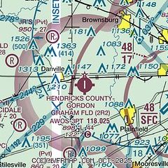
| Sectional chart |
|---|
|
| Airport distance calculator |
|---|
|
|
| Sunrise and sunset |
|---|
|
Times for 10-Mar-2025
| | Local
(UTC-5) | | Zulu
(UTC) |
|---|
| Morning civil twilight | | 06:39 | | 11:39 |
| Sunrise | | 07:06 | | 12:06 |
| Sunset | | 18:46 | | 23:46 |
| Evening civil twilight | | 19:13 | | 00:13 |
|
| Current date and time |
|---|
| Zulu (UTC) | 10-Mar-2025 17:41:56 |
|---|
| Local (UTC-5) | 10-Mar-2025 12:41:56 |
|---|
|
| METAR |
|---|
KIND
9nm E | 101654Z 26007KT 10SM CLR 17/M02 A2990 RMK AO2 SLP125 T01671022 $
|
KEYE
10nm NE | 101653Z AUTO 22006KT 10SM CLR 18/M02 A2989 RMK AO2 SLP120 T01781022
|
KGPC
17nm SW | 101715Z AUTO 23007KT 10SM CLR 16/M02 A2990 RMK AO2 T01641025
|
KHFY
19nm E | 101715Z AUTO 25008KT 10SM CLR 16/M02 A2991 RMK AO2 T01581021
|
KTYQ
20nm NE | 101715Z AUTO 24011G16KT 10SM CLR 17/M01 A2989 RMK AO2 T01651006
|
|
| TAF |
|---|
KIND
9nm E | 101120Z 1012/1118 23007KT P6SM SKC FM101700 24011G17KT P6SM FEW250 FM110000 21009KT P6SM SKC
|
|
| NOTAMs |
|---|
NOTAMs are issued by the DoD/FAA and will open in a separate window not controlled by AirNav.
|
|


