FAA INFORMATION EFFECTIVE 23 JANUARY 2025
Location
| FAA Identifier: | 33J |
| Lat/Long: | 31-03-09.4500N 085-52-08.2000W
31-03.157500N 085-52.136667W
31.0526250,-85.8689444
(estimated) |
| Elevation: | 100.3 ft. / 31 m (estimated) |
| Variation: | 04W (2015) |
| From city: | 2 miles N of GENEVA, AL |
| Time zone: | UTC -6 (UTC -5 during Daylight Saving Time) |
| Zip code: | 36340 |
Airport Operations
| Airport use: | Open to the public |
| Activation date: | 12/1957 |
| Control tower: | no |
| ARTCC: | JACKSONVILLE CENTER |
| FSS: | ANNISTON FLIGHT SERVICE STATION |
| NOTAMs facility: | ANB (NOTAM-D service available) |
| Attendance: | MON-FRI 0800-2100 |
| Wind indicator: | lighted |
| Segmented circle: | no |
| Lights: | ACTVT PAPI RWY 11 & 29; MIRL RWY 11/29 - CTAF. |
| Beacon: | white-green (lighted land airport)
Operates sunset to sunrise. |
Airport Communications
| CTAF/UNICOM: | 122.8 |
| CAIRNS APPROACH: | 133.75 |
| CAIRNS DEPARTURE: | 133.75 |
| WX AWOS-3PT at EDN (15 nm N): | 118.9 (334-347-3524) |
| WX ASOS at BCR (19 nm SE): | 119.825 (850-547-1431) |
- APCH/DEP SVC PRVDD BY JACKSONVILLE ARTCC ON FREQS 134.3/322.55 (DOTHAN RCAG) WHEN CAIRNS APCH/DEP CLSD.
Nearby radio navigation aids
| VOR radial/distance | | VOR name | | Freq | | Var |
|---|
| EDNr176/(14.7) | | ENTERPRISE VOR | | 116.60 | | 03W |
| OZRr212/14.9 | | CAIRNS VOR/DME | | 111.20 | | 03W |
| HEYr213/(22.3) | | HANCHEY VOR | | 110.60 | | 03W |
| RRSr236/26.4 | | WIREGRASS VORTAC | | 111.60 | | 02E |
| NDB name | | Hdg/Dist | | Freq | | Var | | ID |
|---|
| BRYNT | | 198/10.7 | | 212 | | 03W | | OZ | --- --.. |
| BOLL WEEVIL | | 164/18.2 | | 352 | | 03W | | BVG | -... ...- --. |
| LOWE | | 202/19.6 | | 269 | | 03W | | LOR | .-.. --- .-. |
| JUDD | | 121/30.8 | | 264 | | 02W | | JUY | .--- ..- -.-- |
Airport Services
| Fuel available: | 100LL JET-A+ |
| Parking: | tiedowns |
| Airframe service: | MAJOR |
| Powerplant service: | MAJOR |
| Bottled oxygen: | NONE |
| Bulk oxygen: | NONE |
Runway Information
Runway 11/29
| Dimensions: | 3998 x 100 ft. / 1219 x 30 m |
| Surface: | asphalt, in good condition |
| Weight bearing capacity: | | Single wheel: | 30.0 | | Double wheel: | 75.0 |
|
| Runway edge lights: | medium intensity |
| RUNWAY 11 | | RUNWAY 29 |
| Latitude: | 31-03.255833N | | 31-03.059167N |
| Longitude: | 085-52.502167W | | 085-51.771000W |
| Elevation: | 94.4 ft. | | 95.8 ft. |
| Traffic pattern: | left | | left |
| Runway heading: | 111 magnetic, 107 true | | 291 magnetic, 287 true |
| Markings: | nonprecision, in good condition | | nonprecision, in good condition |
| Visual slope indicator: | 4-light PAPI on left (3.50 degrees glide path) | | 4-light PAPI on left (3.50 degrees glide path) |
| Touchdown point: | yes, no lights | | yes, no lights |
| Obstructions: | 62 ft. trees, 551 ft. from runway, 273 ft. left of centerline, 5:1 slope to clear | | 8 ft. tree, 210 ft. from runway, 115 ft. left of centerline, 1:1 slope to clear |
Airport Ownership and Management from official FAA records
| Ownership: | Publicly-owned |
| Owner: | TOWN OF GENEVA
304 AIRPORT ROAD
GENEVA, AL 36340
Phone 334-684-2485 |
| Manager: | BRYAN PIKE
304 AIRPORT ROAD
GENEVA, AL 36340
Phone 334-399-1779 |
Additional Remarks
| - | FOR CD CTC CAIRNS APCH AT 334-255-8402, WHEN APCH CLSD CTC JACKSONVILLE ARTCC AT 904-845-1592. |
Instrument Procedures
NOTE: All procedures below are presented as PDF files. If you need a reader for these files, you should download the free Adobe Reader.NOT FOR NAVIGATION. Please procure official charts for flight.
FAA instrument procedures published for use from 23 January 2025 at 0901Z to 20 February 2025 at 0900z.
IAPs - Instrument Approach Procedures |
|---|
| RNAV (GPS) RWY 11 | |
download (194KB) |
| RNAV (GPS) RWY 29 | |
download (193KB) |
| NOTE: Special Take-Off Minimums/Departure Procedures apply | |
download (394KB) |
Other nearby airports with instrument procedures:
KEDN - Enterprise Municipal Airport (15 nm N)
KOZR - Cairns Army Air Field (Fort Novosel) (16 nm NE)
KBCR - Tri-County Airport (19 nm SE)
KLOR - Lowe Army Heliport (Fort Novosel) (19 nm N)
KHEY - Hanchey Army Heliport (Fort Novosel) (21 nm NE)
|
|

Road maps at:
MapQuest
Bing
Google
| Aerial photo |
|---|
WARNING: Photo may not be current or correct

Do you have a better or more recent aerial photo of Geneva Municipal Airport that you would like to share? If so, please send us your photo.
|
| Sectional chart |
|---|
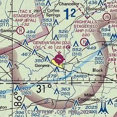
|
| Airport distance calculator |
|---|
|
|
| Sunrise and sunset |
|---|
|
Times for 05-Feb-2025
| | Local
(UTC-6) | | Zulu
(UTC) |
|---|
| Morning civil twilight | | 06:09 | | 12:09 |
| Sunrise | | 06:34 | | 12:34 |
| Sunset | | 17:21 | | 23:21 |
| Evening civil twilight | | 17:46 | | 23:46 |
|
| Current date and time |
|---|
| Zulu (UTC) | 05-Feb-2025 20:22:50 |
|---|
| Local (UTC-6) | 05-Feb-2025 14:22:50 |
|---|
|
| METAR |
|---|
KOZR
16nm NE | 051955Z AUTO 23004KT 10SM BKN180 OVC210 25/17 A3011 RMK AO2 SLP196 T02470172 $
|
KBCR
19nm SE | 051858Z AUTO 00000KT 10SM CLR 26/17 A3015 RMK AO2 SLP167 T02610172
|
KLOR
19nm N | 051955Z AUTO 19005KT 10SM FEW027 OVC190 25/18 A3011 RMK AO2 SLP178 T02480177 $
|
KSXS
19nm N | 051955Z AUTO 00000KT 10SM BKN200 25/18 A3011 RMK AO2 SLP195 T02520181 $
|
KHEY
21nm NE | 051955Z AUTO 24005KT 10SM FEW180 BKN210 25/18 A3008 RMK AO2 SLP186 T02450182 $
|
K0J4
23nm W | 051958Z AUTO 19004KT 10SM FEW029 26/16 A3013 RMK AO2 SLP199 T02560161
|
K54J
24nm SW | 051955Z AUTO 18004KT 10SM SCT030 OVC042 25/16 A3012 RMK AO2 T02460164
|
KDHN
27nm NE | 051953Z 22005KT 10SM FEW026 SCT040 SCT049 24/17 A3015 RMK AO2 SLP205 T02390167 $
|
|
| TAF |
|---|
KOZR
16nm NE | 051137Z 0511/0616 00000KT 0800 FG OVC003 QNH3006INS TEMPO 0510/0515 1600 BR BKN006 OVC020 BECMG 0514/0515 24005KT 9999 NSW FEW015 SCT220 QNH3010INS TEMPO 0515/0516 6000 BR BKN007 OVC012 BECMG 0523/0524 VRB03KT 9999 SCT015 SCT030 QNH3010INS BECMG 0607/0608 VRB03KT 4800 BR BKN007 OVC015 QNH3008INS BECMG 0610/0611 VRB03KT 0800 FG OVC003 QNH3009INS BECMG 0614/0615 22008KT 9999 NSW SCT015 BKN040 QNH3009INS TX27/0520Z TN15/0610Z
|
|
| NOTAMs |
|---|
NOTAMs are issued by the DoD/FAA and will open in a separate window not controlled by AirNav.
|
|


