FAA INFORMATION EFFECTIVE 17 APRIL 2025
Location
| FAA Identifier: | 45R |
| Lat/Long: | 30-20-10.8000N 094-15-27.2000W
30-20.180000N 094-15.453333W
30.3363333,-94.2575556
(estimated) |
| Elevation: | 70.8 ft. / 21.6 m (surveyed) |
| Variation: | 04E (1995) |
| From city: | 3 miles SE of central business district of the associated city |
| Time zone: | UTC -5 (UTC -6 during Standard Time) |
| Zip code: | 77625 |
Airport Operations
| Airport use: | Open to the public |
| Activation date: | 03/1966 |
| Control tower: | no |
| ARTCC: | HOUSTON CENTER |
| FSS: | MONTGOMERY COUNTY FLIGHT SERVICE STATION |
| NOTAMs facility: | CXO (NOTAM-D service available) |
| Attendance: | 0800-1730 |
| Wind indicator: | lighted |
| Segmented circle: | yes |
| Lights: | MIRL RY 13/31 PRESET LOW INTST DUSK-DAWN; TO INCR INTST ACTVT - CTAF. |
| Beacon: | white-green (lighted land airport)
Operates sunset to sunrise. |
Airport Communications
| CTAF/UNICOM: | 122.8 |
| HOUSTON APPROACH: | 121.3 [1345-0600Z++ MON-THU; 1345-2345Z++ FRI; CLSD SAT, SUN AND HOL EXC BY NOTAM, HRS SUBJ TO CHG.] |
| HOUSTON DEPARTURE: | 121.3 [1345-0600Z++ MON-THU; 1345-2345Z++ FRI; CLSD SAT, SUN AND HOL EXC BY NOTAM, HRS SUBJ TO CHG.] |
| WX AWOS-3PT at BMT (16 nm S): | 118.425 (409-866-2832) |
Nearby radio navigation aids
| VOR radial/distance | | VOR name | | Freq | | Var |
|---|
| DASr061/21.9 | | DAISETTA VORTAC | | 116.90 | | 05E |
| NDB name | | Hdg/Dist | | Freq | | Var | | ID |
|---|
| GOODHUE | | 344/16.1 | | 368 | | 07E | | GDE | --. -.. . |
Airport Services
| Fuel available: | 100LL JET-A
100LL:24 HR SELF SERVE FUEL. |
| Parking: | tiedowns |
Runway Information
Runway 13/31
| Dimensions: | 4303 x 76 ft. / 1312 x 23 m |
| Surface: | asphalt, in good condition |
| Weight bearing capacity: | |
| Runway edge lights: | medium intensity |
| Runway edge markings: | RY & TWY MKGS INCLUDING HOLD LINES FADED. |
| RUNWAY 13 | | RUNWAY 31 |
| Latitude: | 30-20.450635N | | 30-19.908947N |
| Longitude: | 094-15.717230W | | 094-15.188320W |
| Elevation: | 68.7 ft. | | 65.4 ft. |
| Traffic pattern: | left | | left |
| Runway heading: | 136 magnetic, 140 true | | 316 magnetic, 320 true |
| Markings: | nonprecision, in poor condition | | nonprecision, in poor condition |
| Visual slope indicator: | 2-light PAPI on left (3.00 degrees glide path) | | 2-light PAPI on left (4.00 degrees glide path)
PAPI OTS |
| Touchdown point: | yes, no lights | | yes, no lights |
| Obstructions: | 90 ft. tree, 1736 ft. from runway, 380 ft. right of centerline, 17:1 slope to clear | | 65 ft. tree, 935 ft. from runway, 270 ft. both sides of centerline, 11:1 slope to clear |
Airport Ownership and Management from official FAA records
| Ownership: | Publicly-owned |
| Owner: | HARDIN COUNTY
PO BOX 760
KOUNTZE, TX 77625
Phone 409-246-5120 |
| Manager: | DALE WILLIFORD
PO BOX 502
KOUNTZE, TX 77625
Phone (409) 782-7620 |
Additional Remarks
| - | FOR CD CTC HOUSTON APCH AT 281-443-5844 TO CNL IFR CALL 281-443-5888. |
Instrument Procedures
NOTE: All procedures below are presented as PDF files. If you need a reader for these files, you should download the free Adobe Reader.NOT FOR NAVIGATION. Please procure official charts for flight.
FAA instrument procedures published for use from 17 April 2025 at 0901Z to 15 May 2025 at 0900z.
IAPs - Instrument Approach Procedures |
|---|
| RNAV (GPS) RWY 13 | |
download (174KB) |
| NOTE: Special Take-Off Minimums/Departure Procedures apply | |
download (208KB) |
Other nearby airports with instrument procedures:
KBMT - Beaumont Municipal Airport (16 nm S)
KBPT - Jack Brooks Regional Airport (26 nm SE)
T78 - Liberty Municipal Airport (28 nm SW)
KORG - Orange County Airport (28 nm SE)
T90 - Chambers County/Winnie Stowell Airport (32 nm S)
|
|

Road maps at:
MapQuest
Bing
Google
| Aerial photo |
|---|
WARNING: Photo may not be current or correct

Do you have a better or more recent aerial photo of Hawthorne Field Airport that you would like to share? If so, please send us your photo.
|
| Sectional chart |
|---|
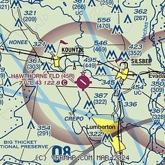
|
| Airport distance calculator |
|---|
|
|
| Sunrise and sunset |
|---|
|
Times for 24-Apr-2025
| | Local
(UTC-5) | | Zulu
(UTC) |
|---|
| Morning civil twilight | | 06:16 | | 11:16 |
| Sunrise | | 06:41 | | 11:41 |
| Sunset | | 19:49 | | 00:49 |
| Evening civil twilight | | 20:14 | | 01:14 |
|
| Current date and time |
|---|
| Zulu (UTC) | 24-Apr-2025 09:33:59 |
|---|
| Local (UTC-5) | 24-Apr-2025 04:33:59 |
|---|
|
| METAR |
|---|
KBMT
16nm S | 240915Z AUTO 00000KT 10SM BKN009 OVC013 20/18 A2997 RMK AO2 T01950182
|
KBPT
26nm SE | 240853Z AUTO 04004KT 10SM FEW013 SCT030 BKN042 21/20 A2997 RMK AO2 SLP146 T02060200 55004
|
KORG
28nm SE | 240915Z AUTO 00000KT 7SM SCT011 BKN021 OVC028 23/22 A3000 RMK AO2 T02270223 PWINO
|
|
| TAF |
|---|
KBPT
26nm SE | 240520Z 2406/2506 18006KT P6SM -SHRA VCTS BKN025CB OVC050 TEMPO 2406/2408 2SM TSRA OVC015CB FM240800 15005KT 6SM BR OVC015 TEMPO 2409/2413 3SM BR OVC007 FM241500 15010KT P6SM BKN025 FM241800 18014G22KT P6SM VCTS BKN035CB PROB30 2418/2424 2SM TSRA BR OVC025CB FM250000 15010KT P6SM BKN050
|
|
| NOTAMs |
|---|
NOTAMs are issued by the DoD/FAA and will open in a separate window not controlled by AirNav.
|
|


