FAA INFORMATION EFFECTIVE 20 FEBRUARY 2025
Location
| FAA Identifier: | 4U6 |
| Lat/Long: | 47-25-06.0000N 105-33-39.2000W
47-25.100000N 105-33.653333W
47.4183333,-105.5608889
(estimated) |
| Elevation: | 2441.4 ft. / 744.1 m (surveyed) |
| Variation: | 09E (2015) |
| From city: | 1 mile E of CIRCLE, MT |
| Time zone: | UTC -7 (UTC -6 during Daylight Saving Time) |
| Zip code: | 59215 |
Airport Operations
| Airport use: | Open to the public |
| Activation date: | 04/1940 |
| Control tower: | no |
| ARTCC: | SALT LAKE CITY CENTER |
| FSS: | GREAT FALLS FLIGHT SERVICE STATION |
| NOTAMs facility: | GTF (NOTAM-D service available) |
| Attendance: | MON-FRI 0800-1700 |
| Wind indicator: | lighted, WIND TEE HAS BEEN REMOVED, USE LIGHTED WIND SOCK |
| Segmented circle: | yes |
| Lights: | ACTVT MIRL RY 12/30 & PAPI RY 12 AND RY 30 - CTAF. |
| Beacon: | white-green (lighted land airport)
Operates sunset to sunrise. |
Airport Communications
| CTAF/UNICOM: | 122.8 |
| WX AWOS-2: | 119.025 (406-485-3760) |
- APCH/DEP CTL SVC PRVDD BY SALT LAKE ARTCC ( ZLC) ON FREQS 126.85/305.2 (GLASGOW RCAG).
Airport Services
| Fuel available: | 100LL |
| Parking: | hangars and tiedowns |
| Airframe service: | MAJOR |
| Powerplant service: | MAJOR |
| Bottled oxygen: | NONE |
| Bulk oxygen: | NONE |
Runway Information
Runway 12/30
| Dimensions: | 4100 x 75 ft. / 1250 x 23 m |
| Surface: | asphalt, in poor condition
TRANSVERSE CRACKS AT 100 FT INTVLS WITH SGFNT WID AND DPT. |
| Weight bearing capacity: | |
| Runway edge lights: | medium intensity |
| RUNWAY 12 | | RUNWAY 30 |
| Latitude: | 47-25.368475N | | 47-24.852410N |
| Longitude: | 105-33.934618W | | 105-33.295120W |
| Elevation: | 2425.2 ft. | | 2441.4 ft. |
| Traffic pattern: | left | | left |
| Runway heading: | 131 magnetic, 140 true | | 311 magnetic, 320 true |
| Markings: | nonprecision, in good condition | | nonprecision, in good condition |
| Visual slope indicator: | 2-light PAPI on left (3.00 degrees glide path) | | 2-light PAPI on left (3.00 degrees glide path) |
| Touchdown point: | yes, no lights | | yes, no lights |
Runway 3/21
| Dimensions: | 2280 x 195 ft. / 695 x 59 m |
| Surface: | turf, in poor condition
RWY IS RUF, WITH LONG GRASS, RWY EDGES ARE NOT MKD.
UNUSBL IN WET WEATHER. |
| Runway edge markings: | 03/21 THRS MKD WITH RED CONES. |
| Operational restrictions: | CLSD WINTER MONTHS. |
| RUNWAY 3 | | RUNWAY 21 |
| Latitude: | 47-24.958702N | | 47-25.207113N |
| Longitude: | 105-33.926897W | | 105-33.513017W |
| Elevation: | 2425.8 ft. | | 2422.1 ft. |
| Traffic pattern: | left | | left |
| Runway heading: | 039 magnetic, 048 true | | 220 magnetic, 229 true |
| Touchdown point: | yes, no lights | | yes, no lights |
Airport Ownership and Management from official FAA records
| Ownership: | Publicly-owned |
| Owner: | MC CONE COUNTY & CITY OF CIRCLE
COUNTY COURTHOUSE PO BOX199
CIRCLE, MT 59215
Phone 406-485-3505 |
| Manager: | JEFF SKYBERG
BOX 336
CIRCLE, MT 59215
Phone 406-485-2481 |
Additional Remarks
| - | HAS -8 FT DRAINAGE DITCH 200 FT FM RY 03/21 THLDS. |
| - | FOR CD CTC SALT LAKE ARTCC AT 801-320-2568. |
Instrument Procedures
NOTE: All procedures below are presented as PDF files. If you need a reader for these files, you should download the free Adobe Reader.NOT FOR NAVIGATION. Please procure official charts for flight.
FAA instrument procedures published for use from 20 February 2025 at 0901Z to 20 March 2025 at 0900Z.
IAPs - Instrument Approach Procedures |
|---|
| RNAV (GPS) RWY 12 | |
download (222KB) |
| RNAV (GPS) RWY 30 | |
download (190KB) |
| NOTE: Special Take-Off Minimums/Departure Procedures apply | |
download (566KB) |
Other nearby airports with instrument procedures:
KGDV - Dawson Community Airport (35 nm SE)
KOLF - L M Clayton Airport (41 nm N)
PO1 - Poplar Municipal Airport (46 nm N)
KSDY - Sidney-Richland Regional Airport (58 nm E)
KMLS - Frank Wiley Field Airport (61 nm S)
|
|

Road maps at:
MapQuest
Bing
Google
| Aerial photo |
|---|
WARNING: Photo may not be current or correct

Do you have a better or more recent aerial photo of Circle Town County Airport that you would like to share? If so, please send us your photo.
|
| Sectional chart |
|---|
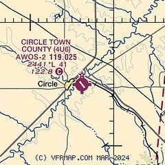
|
| Airport distance calculator |
|---|
|
|
| Sunrise and sunset |
|---|
|
Times for 13-Mar-2025
| | Local
(UTC-7) | | Zulu
(UTC) |
|---|
| Morning civil twilight | | 05:50 | | 12:50 |
| Sunrise | | 06:20 | | 13:20 |
| Sunset | | 18:03 | | 01:03 |
| Evening civil twilight | | 18:34 | | 01:34 |
|
| Current date and time |
|---|
| Zulu (UTC) | 13-Mar-2025 20:22:46 |
|---|
| Local (UTC-7) | 13-Mar-2025 13:22:46 |
|---|
|
| TAF |
|---|
KGDV
36nm SE | 131726Z 1318/1418 VRB05KT P6SM BKN130 FM140900 32015G24KT P6SM SCT100 PROB30 1413/1415 5SM -RASN OVC080 FM141500 32020G31KT 5SM -RASN OVC027
|
KOLF
41nm N | 131726Z 1318/1418 10007KT P6SM SCT160 PROB30 1409/1412 6SM -RA OVC070 FM141500 31015KT 3SM -RASN OVC025 FM141700 31015KT P6SM OVC022 PROB30 1417/1418 2SM -SN OVC018
|
|
| NOTAMs |
|---|
NOTAMs are issued by the DoD/FAA and will open in a separate window not controlled by AirNav.
|
|


