FAA INFORMATION EFFECTIVE 20 FEBRUARY 2025
Location
| FAA Identifier: | 60F |
| Lat/Long: | 33-38-54.6600N 099-15-40.7000W
33-38.911000N 099-15.678333W
33.6485167,-99.2613056
(estimated) |
| Elevation: | 1344 ft. / 409.7 m (surveyed) |
| Variation: | 07E (1995) |
| From city: | 3 miles N of SEYMOUR, TX |
| Time zone: | UTC -6 (UTC -5 during Daylight Saving Time) |
| Zip code: | 76380 |
Airport Operations
| Airport use: | Open to the public |
| Activation date: | 10/1965 |
| Control tower: | no |
| ARTCC: | FORT WORTH CENTER |
| FSS: | FORT WORTH FLIGHT SERVICE STATION |
| NOTAMs facility: | FTW (NOTAM-D service available) |
| Attendance: | UNATNDD |
| Wind indicator: | lighted |
| Segmented circle: | yes |
| Lights: | SS-SR |
| Beacon: | white-green (lighted land airport)
Operates sunset to sunrise. |
Airport Communications
- APCH/DEP CTL SVC PRVDD BY FORT WORTH ARTCC (ZFW) ON FREQS 133.5/350.35 (WICHITA FALLS NR 2 RCAG).
Nearby radio navigation aids
| VOR radial/distance | | VOR name | | Freq | | Var |
|---|
| SPSr229/39.0 | | WICHITA FALLS VORTAC | | 112.70 | | 10E |
Airport Services
| Parking: | tiedowns |
| Airframe service: | NONE |
| Powerplant service: | NONE |
| Bottled oxygen: | NONE |
| Bulk oxygen: | NONE |
Runway Information
Runway 17/35
| Dimensions: | 4300 x 60 ft. / 1311 x 18 m |
| Surface: | asphalt, in excellent condition |
| Weight bearing capacity: | |
| Runway edge lights: | medium intensity |
| RUNWAY 17 | | RUNWAY 35 |
| Latitude: | 33-39.265333N | | 33-38.556667N |
| Longitude: | 099-15.678333W | | 099-15.678333W |
| Elevation: | 1344.0 ft. | | 1337.9 ft. |
| Traffic pattern: | left | | left |
| Runway heading: | 173 magnetic, 180 true | | 353 magnetic, 000 true |
| Markings: | nonprecision, in good condition | | nonprecision, in good condition |
| Visual slope indicator: | 2-light PAPI on left (3.00 degrees glide path) | | |
| Touchdown point: | yes, no lights | | yes, no lights |
| Obstructions: | 4 ft. fence, lighted, 201 ft. from runway, 200 ft. left and right of centerline
4 FT FENCE 200 L & R, 0-199 FT DSTC. | | 25 ft. hangar, lighted, 207 ft. from runway, 249 ft. right of centerline
4 FT FENCE 203 FT L AT RWY THR; 20 FT HNGRS 75 FT DSTC, 240 FT R. |
Airport Ownership and Management from official FAA records
| Ownership: | Publicly-owned |
| Owner: | CITY OF SEYMOUR
PO BOX 31
SEYMOUR, TX 76380
Phone 940-889-3148 |
| Manager: | JEFF BRASHER
PO BOX 31
SEYMOUR, TX 76380
Phone 940-889-0025
CITY ADMINISTRATOR |
Additional Remarks
| - | FOR CD CTC FORT WORTH ARTCC AT 817-858-7584. |
Instrument Procedures
NOTE: All procedures below are presented as PDF files. If you need a reader for these files, you should download the free Adobe Reader.NOT FOR NAVIGATION. Please procure official charts for flight.
FAA instrument procedures published for use from 20 February 2025 at 0901Z to 20 March 2025 at 0900Z.
IAPs - Instrument Approach Procedures |
|---|
| RNAV (GPS) RWY 17 | |
download (171KB) |
| NOTE: Special Take-Off Minimums/Departure Procedures apply | |
download (113KB) |
Other nearby airports with instrument procedures:
KONY - Olney Municipal Airport (28 nm SE)
F05 - Wilbarger County Airport (35 nm N)
15F - Haskell Municipal Airport (36 nm SW)
F14 - Wichita Valley Airport (37 nm NE)
KCWC - Kickapoo Downtown Airport (41 nm E)
|
|

Road maps at:
MapQuest
Bing
Google
| Aerial photo |
|---|
WARNING: Photo may not be current or correct
 Photo by Victor Estrada
Taken in October 2007
Photo by Victor Estrada
Taken in October 2007
Do you have a better or more recent aerial photo of Seymour Municipal Airport that you would like to share? If so, please send us your photo.
|
| Sectional chart |
|---|
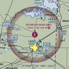
|
| Airport distance calculator |
|---|
|
|
| Sunrise and sunset |
|---|
|
Times for 09-Mar-2025
| | Local
(UTC-6) | | Zulu
(UTC) |
|---|
| Morning civil twilight | | 06:32 | | 12:32 |
| Sunrise | | 06:56 | | 12:56 |
| Sunset | | 18:39 | | 00:39 |
| Evening civil twilight | | 19:04 | | 01:04 |
|
| Current date and time |
|---|
| Zulu (UTC) | 09-Mar-2025 21:57:54 |
|---|
| Local (UTC-6) | 09-Mar-2025 15:57:54 |
|---|
|
| METAR |
|---|
KF05
35nm N | 092135Z AUTO 31010KT 10SM CLR 16/04 A3014 RMK AO2 T01610035
|
KCWC
40nm E | 092155Z AUTO 35007G18KT 10SM CLR 16/M03 A3014 RMK AO2 T01551026
|
KSPS
43nm NE | 092152Z AUTO 32010KT 10SM CLR 17/M01 A3012 RMK AO2 SLP198 T01671006 $
|
KFDR
44nm N | 092153Z AUTO 32010KT 10SM CLR 16/02 A3010 RMK AO2 SLP187 T01610017 $
|
KRPH
48nm SE | 092135Z AUTO 33014KT 10SM CLR 15/03 A3012 RMK AO2 T01510028
|
|
| TAF |
|---|
KSPS
43nm NE | 091720Z 0918/1018 31008KT P6SM SCT080 FM100200 28005KT P6SM SKC FM101500 23009KT P6SM SKC
|
|
| NOTAMs |
|---|
NOTAMs are issued by the DoD/FAA and will open in a separate window not controlled by AirNav.
|
|


