FAA INFORMATION EFFECTIVE 26 DECEMBER 2024
Location
| FAA Identifier: | 62D |
| Lat/Long: | 41-16-01.3000N 080-55-38.5000W
41-16.021667N 080-55.641667W
41.2670278,-80.9273611
(estimated) |
| Elevation: | 905 ft. / 276 m (estimated) |
| Variation: | 07W (1985) |
| From city: | 5 miles NW of WARREN, OH |
| Time zone: | UTC -5 (UTC -4 during Daylight Saving Time) |
| Zip code: | 44470 |
Airport Operations
| Airport use: | Open to the public |
| Control tower: | no |
| ARTCC: | CLEVELAND CENTER |
| FSS: | CLEVELAND FLIGHT SERVICE STATION |
| NOTAMs facility: | CLE (NOTAM-D service available) |
| Attendance: | IREG |
| Wind indicator: | yes |
| Segmented circle: | no |
Airport Communications
| CTAF/UNICOM: | 122.8 |
| WX ASOS at YNG (11 nm E): | PHONE 330-856-9357 |
| WX AWOS-3 at POV (15 nm W): | 118.675 (330-298-9353) |
Nearby radio navigation aids
| VOR radial/distance | | VOR name | | Freq | | Var |
|---|
| ACOr056/15.6 | | AKRON VOR/DME | | 114.40 | | 04W |
| CXRr150/18.4 | | CHARDON VOR/DME | | 112.70 | | 05W |
| BSVr040/39.0 | | BRIGGS VOR/DME | | 114.05 | | 04W |
| NDB name | | Hdg/Dist | | Freq | | Var | | ID |
|---|
| CASTLE | | 311/27.4 | | 272 | | 09W | | UCP | ..- -.-. .--. |
Airport Services
| Fuel available: | 100LL MOGAS
100LL:FUEL AVBL H24 VIA CREDIT CARD. |
| Parking: | hangars and tiedowns |
| Airframe service: | NONE |
| Powerplant service: | NONE |
| Bottled oxygen: | NONE |
| Bulk oxygen: | NONE |
Runway Information
Runway 4/22
| Dimensions: | 2907 x 30 ft. / 886 x 9 m |
| Surface: | asphalt, in good condition |
| RUNWAY 4 | | RUNWAY 22 |
| Latitude: | 41-15.906023N | | 41-16.297430N |
| Longitude: | 080-55.872067W | | 080-55.506663W |
| Elevation: | 895.8 ft. | | 901.7 ft. |
| Traffic pattern: | left | | left |
| Runway heading: | 042 magnetic, 035 true | | 222 magnetic, 215 true |
| Displaced threshold: | 87 ft. | | 578 ft. |
| Markings: | basic, in good condition | | basic, in good condition |
| Runway end identifier lights: | no | | no |
| Obstructions: | 75 ft. trees, 788 ft. from runway, 221 ft. left of centerline, 7:1 slope to clear | | 110 ft. trees, 329 ft. from runway, 156 ft. left of centerline, 1:1 slope to clear
23 FT PLINE MKD WITH BALLS, 0 FT DIST, 125 FT R; 60 FT TREE, 160 FT DIST. |
Runway 18/36
| Dimensions: | 2700 x 100 ft. / 823 x 30 m |
| Surface: | turf, in good condition |
| Runway edge markings: | YELLOW & ORANGE BUCKETS. |
| Operational restrictions: | -3 FT DITCH EACH SIDE OF RWY EDGE. |
| RUNWAY 18 | | RUNWAY 36 |
| Latitude: | 41-16.158625N | | 41-15.714070N |
| Longitude: | 080-55.587097W | | 080-55.591072W |
| Elevation: | 898.1 ft. | | 893.6 ft. |
| Traffic pattern: | left | | left |
| Runway heading: | 187 magnetic, 180 true | | 007 magnetic, 360 true |
| Runway end identifier lights: | no | | no |
| Obstructions: | 95 ft. trees, 1075 ft. from runway, 120 ft. right of centerline, 11:1 slope to clear | | 75 ft. trees, 110 ft. from runway, 38 ft. right of centerline, 1:1 slope to clear
APCH SLP 11:1 TO DTHR OVR 75 FT TREES, 675 FT DIST, 0 FT B. |
Airport Ownership and Management from official FAA records
| Ownership: | Privately-owned |
| Owner: | SKEETS ARPT INC
3599 HERR FIELDHOUSE RD
SOUTHINGTON, OH 44470-9564
Phone 330-898-3615
UNATNDD ARPT TEL. |
| Manager: | MARK PAUL
3599 HERR FIELDHOUSE RD
SOUTHINGTON, OH 44470-9564
Phone 330-883-3989
CELL. |
Additional Remarks
| - | DALGT OPS ONLY. |
| - | FOR CD CTC YOUNGSTOWN APCH AT 330-856-4806, WHEN APCH CLSD CTC CLEVELAND ARTCC AT 440-774-0232/0490. |
Instrument Procedures
There are no published instrument procedures at 62D.
Some nearby airports with instrument procedures:
KYNG - Youngstown/Warren Regional Airport (11 nm E)
7G8 - Geauga County Airport (13 nm NW)
KPOV - Portage County Airport (15 nm W)
38D - Salem Airpark (19 nm S)
4G4 - Youngstown Elser Metro Airport (22 nm SE)
|
|

Road maps at:
MapQuest
Bing
Google
| Aerial photo |
|---|
WARNING: Photo may not be current or correct
 Photo taken 07-May-2006
Do you have a better or more recent aerial photo of Warren Airport that you would like to share? If so, please send us your photo.
|
| Sectional chart |
|---|
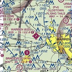
|
| Airport distance calculator |
|---|
|
|
| Sunrise and sunset |
|---|
|
Times for 13-Jan-2025
| | Local
(UTC-5) | | Zulu
(UTC) |
|---|
| Morning civil twilight | | 07:19 | | 12:19 |
| Sunrise | | 07:49 | | 12:49 |
| Sunset | | 17:16 | | 22:16 |
| Evening civil twilight | | 17:46 | | 22:46 |
|
| Current date and time |
|---|
| Zulu (UTC) | 13-Jan-2025 19:17:18 |
|---|
| Local (UTC-5) | 13-Jan-2025 14:17:18 |
|---|
|
| METAR |
|---|
KYNG
12nm E | 131851Z 24014G21KT 10SM BKN026 M03/M10 A2997 RMK AO2 SLP161 BKN V SCT T10331100
|
KPOV
15nm W | 131855Z AUTO 25009KT 10SM SCT030 SCT035 M03/M11 A2998 RMK AO2 T10291108 PWINO
|
|
| TAF |
|---|
KYNG
12nm E | 131742Z 1318/1418 25012G20KT P6SM BKN025 TEMPO 1318/1322 SCT025 FM140000 24010KT P6SM OVC020 FM141600 24014G22KT P6SM -SHSN OVC015
|
|
| NOTAMs |
|---|
NOTAMs are issued by the DoD/FAA and will open in a separate window not controlled by AirNav.
|
|


