FAA INFORMATION EFFECTIVE 23 JANUARY 2025
Location
| FAA Identifier: | 6R6 |
| Lat/Long: | 30-02-47.3000N 102-12-47.4000W
30-02.788333N 102-12.790000W
30.0464722,-102.2131667
(estimated) |
| Elevation: | 2323.4 ft. / 708.2 m (surveyed) |
| Variation: | 09E (1985) |
| From city: | 5 miles W of DRYDEN, TX |
| Time zone: | UTC -6 (UTC -5 during Daylight Saving Time) |
| Zip code: | 78851 |
Airport Operations
| Airport use: | Open to the public |
| Activation date: | 11/1943 |
| Control tower: | no |
| ARTCC: | HOUSTON CENTER |
| FSS: | SAN ANGELO FLIGHT SERVICE STATION |
| NOTAMs facility: | SJT (NOTAM-D service available) |
| Attendance: | INTMNT |
| Wind indicator: | lighted |
| Segmented circle: | yes |
| Lights: | ACTVT MIRL RWY 13/31 - CTAF. HELI PAD LGTS, 5 CLICKS - 123.05. |
| Beacon: | white-green (lighted land airport)
Operates sunset to sunrise. |
Airport Communications
Airport Services
| Parking: | tiedowns |
| Airframe service: | NONE |
| Powerplant service: | NONE |
Runway Information
Runway 13/31
| Dimensions: | 4526 x 75 ft. / 1380 x 23 m |
| Surface: | asphalt, in poor condition |
| Weight bearing capacity: | |
| Runway edge lights: | medium intensity |
| RUNWAY 13 | | RUNWAY 31 |
| Latitude: | 30-03.055987N | | 30-02.523283N |
| Longitude: | 102-13.233130W | | 102-12.632020W |
| Elevation: | 2323.4 ft. | | 2291.2 ft. |
| Traffic pattern: | left | | left |
| Runway heading: | 127 magnetic, 136 true | | 307 magnetic, 316 true |
| Markings: | basic, in poor condition | | basic, in poor condition |
| Touchdown point: | yes, no lights | | yes, no lights |
| Obstructions: | 8 ft. fence, 278 ft. from runway, 130 ft. right of centerline, 9:1 slope to clear | | none |
Runway 4/22
| Dimensions: | 4525 x 75 ft. / 1379 x 23 m |
| Surface: | asphalt, in poor condition |
| Weight bearing capacity: | |
| RUNWAY 4 | | RUNWAY 22 |
| Latitude: | 30-02.525863N | | 30-03.048622N |
| Longitude: | 102-12.953938W | | 102-12.341585W |
| Elevation: | 2302.5 ft. | | 2288.0 ft. |
| Traffic pattern: | left | | left |
| Runway heading: | 037 magnetic, 046 true | | 217 magnetic, 226 true |
| Markings: | basic, in poor condition | | basic, in poor condition |
| Touchdown point: | yes, no lights | | yes, no lights |
| Obstructions: | none | | 5 ft. brush, 266 ft. from runway, 125 ft. left and right of centerline, 13:1 slope to clear
10 FT BRUSH, 15 FT DSTC, 20 FT R. |
Airport Ownership and Management from official FAA records
| Ownership: | Publicly-owned |
| Owner: | TERRELL COUNTY
TERRELL CO COURTHOUSE
SANDERSON, TX 79848
Phone 432-345-2421 |
| Manager: | C D CURRY
PO BOX 350
SANDERSON, TX 79848
Phone 432-345-6731 |
Additional Remarks
| - | FOR CD CTC HOUSTON ARTCC AT 281-230-5622. |
| - | RWY 04/22 AND RWY 13/31 EXTSV CRACKING, LOOSE STONES ON SFC. |
| - | RWY 13/31 AND RWY 04/22 MRKG POOR DUE TO PAVEMENT DETERIORATION. |
Instrument Procedures
There are no published instrument procedures at 6R6.
Some nearby airports with instrument procedures:
KFST - Fort Stockton-Pecos County Airport (63 nm NW)
KOZA - Ozona Municipal Airport (67 nm NE)
KDRT - Del Rio International Airport (78 nm SE)
E38 - Alpine-Casparis Municipal Airport (79 nm W)
E41 - Reagan County Airport (79 nm NE)
|
|

Road maps at:
MapQuest
Bing
Google
| Aerial photo |
|---|
WARNING: Photo may not be current or correct
 Photo by Hamlin Photo, provided courtesy of Ameriseal of Ohio
Taken late February 2006
Do you have a better or more recent aerial photo of Terrell County Airport that you would like to share? If so, please send us your photo.
|
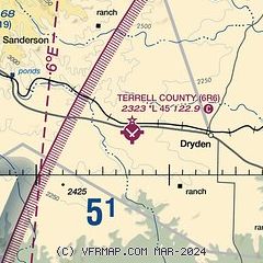
| Sectional chart |
|---|

|
| Airport distance calculator |
|---|
|
|
| Sunrise and sunset |
|---|
|
Times for 05-Feb-2025
| | Local
(UTC-6) | | Zulu
(UTC) |
|---|
| Morning civil twilight | | 07:13 | | 13:13 |
| Sunrise | | 07:38 | | 13:38 |
| Sunset | | 18:28 | | 00:28 |
| Evening civil twilight | | 18:53 | | 00:53 |
|
| Current date and time |
|---|
| Zulu (UTC) | 06-Feb-2025 00:13:34 |
|---|
| Local (UTC-6) | 05-Feb-2025 18:13:34 |
|---|
|
| METAR |
|---|
| K6R6 | 052351Z AUTO 13010KT 27/17 A2991 RMK AO1 SLP098 T02670172 10283 20217 55009
|
|
| NOTAMs |
|---|
NOTAMs are issued by the DoD/FAA and will open in a separate window not controlled by AirNav.
|
|


