FAA INFORMATION EFFECTIVE 17 APRIL 2025
Location
| FAA Identifier: | 7M4 |
| Lat/Long: | 35-41-28.1000N 090-00-36.4000W
35-41.468333N 090-00.606667W
35.6911389,-90.0101111
(estimated) |
| Elevation: | 234.7 ft. / 71.5 m (surveyed) |
| Variation: | 02E (1985) |
| From city: | 2 miles SW of OSCEOLA, AR |
| Time zone: | UTC -5 (UTC -6 during Standard Time) |
| Zip code: | 72370 |
Airport Operations
| Airport use: | Open to the public |
| Activation date: | 10/1965 |
| Control tower: | no |
| ARTCC: | MEMPHIS CENTER |
| FSS: | JONESBORO FLIGHT SERVICE STATION |
| NOTAMs facility: | JBR (NOTAM-D service available) |
| Attendance: | UNATNDD
FOR ARPT ATTENDANT CALL 870-532-7309. |
| Wind indicator: | lighted |
| Segmented circle: | yes |
| Lights: | ACTVT REIL RWY 19; MIRL RWY 01/19 - CTAF. |
| Beacon: | white-green (lighted land airport)
Operates sunset to sunrise. |
Airport Communications
| CTAF/UNICOM: | 122.8 |
| MEMPHIS APPROACH: | 119.1 |
| MEMPHIS DEPARTURE: | 119.1 |
| WX ASOS at HKA (17 nm NE): | 135.025 (870-763-8206) |
Nearby radio navigation aids
| VOR radial/distance | | VOR name | | Freq | | Var |
|---|
| JBRr111/30.2 | | JONESBORO VOR/DME | | 115.85 | | 00W |
| GQEr044/30.8 | | GILMORE VOR/DME | | 113.00 | | 04E |
Airport Services
| Fuel available: | 100LL
100LL:FUEL AVBL 24 HRS WITH CREDIT CARD. |
| Parking: | hangars and tiedowns |
| Airframe service: | NONE |
| Powerplant service: | NONE |
| Bottled oxygen: | NONE |
| Bulk oxygen: | NONE |
Runway Information
Runway 1/19
| Dimensions: | 3799 x 75 ft. / 1158 x 23 m |
| Surface: | asphalt, in good condition |
| Weight bearing capacity: | |
| Runway edge lights: | medium intensity |
| RUNWAY 1 | | RUNWAY 19 |
| Latitude: | 35-41.159252N | | 35-41.777922N |
| Longitude: | 090-00.666283W | | 090-00.547943W |
| Elevation: | 234.3 ft. | | 234.1 ft. |
| Traffic pattern: | left | | left |
| Runway heading: | 007 magnetic, 009 true | | 187 magnetic, 189 true |
| Markings: | basic, in good condition | | nonprecision, in good condition |
| Runway end identifier lights: | yes | | yes |
| Touchdown point: | yes, no lights | | yes, no lights |
| Obstructions: | 25 ft. tree, 815 ft. from runway, 275 ft. left of centerline, 24:1 slope to clear | | 31 ft. pole, lighted, 550 ft. from runway, 380 ft. left of centerline, 11:1 slope to clear |
Airport Ownership and Management from official FAA records
| Ownership: | Publicly-owned |
| Owner: | CITY OF OSCEOLA
PO BOX 403
OSCEOLA, AR 72370
Phone 870-563-5245 |
| Manager: | JUSTIN BAGLEY
200 AIRPORT ROAD
OSCEOLA, AR 72370
Phone 870-763-0200 |
Additional Remarks
| - | FOR CD CTC MEMPHIS APCH AT 901-842-8457. |
Instrument Procedures
NOTE: All procedures below are presented as PDF files. If you need a reader for these files, you should download the free Adobe Reader.NOT FOR NAVIGATION. Please procure official charts for flight.
FAA instrument procedures published for use from 17 April 2025 at 0901Z to 15 May 2025 at 0900z.
IAPs - Instrument Approach Procedures |
|---|
| RNAV (GPS) RWY 19 | |
download (206KB) |
| NOTE: Special Take-Off Minimums/Departure Procedures apply | |
download (131KB) |
Other nearby airports with instrument procedures:
KMXA - Manila Municipal Airport (14 nm NW)
KBYH - Arkansas International Airport (17 nm N)
KHKA - Blytheville Municipal Airport (17 nm NE)
KNQA - Millington/Memphis Airport (21 nm S)
M04 - Covington Municipal Airport (22 nm E)
|
|

Road maps at:
MapQuest
Bing
Google
| Aerial photo |
|---|
WARNING: Photo may not be current or correct
 Photo courtesy of the Arkansas Department of Aeronautics
Taken in the Spring of 2007
Photo courtesy of the Arkansas Department of Aeronautics
Taken in the Spring of 2007
Do you have a better or more recent aerial photo of Osceola Municipal Airport that you would like to share? If so, please send us your photo.
|
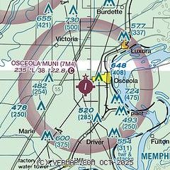
| Sectional chart |
|---|
|
| Airport distance calculator |
|---|
|
|
| Sunrise and sunset |
|---|
|
Times for 22-Apr-2025
| | Local
(UTC-5) | | Zulu
(UTC) |
|---|
| Morning civil twilight | | 05:53 | | 10:53 |
| Sunrise | | 06:19 | | 11:19 |
| Sunset | | 19:38 | | 00:38 |
| Evening civil twilight | | 20:05 | | 01:05 |
|
| Current date and time |
|---|
| Zulu (UTC) | 22-Apr-2025 19:14:34 |
|---|
| Local (UTC-5) | 22-Apr-2025 14:14:34 |
|---|
|
| METAR |
|---|
KHKA
17nm NE | 221853Z AUTO 12009KT 10SM CLR 24/12 A3007 RMK AO2 SLP180 T02390117 $
|
KNQA
22nm S | 221850Z 12003KT 10SM SCT047 25/13 A3005
|
KM04
22nm E | 221850Z AUTO VRB05KT 9SM SCT049 24/13 A3006 RMK A01
|
KTKX
32nm N | 221855Z AUTO 12006G12KT 6SM HZ CLR 23/14 A3007 RMK AO2
|
KJBR
32nm W | 221853Z AUTO VRB05KT 10SM CLR 24/12 A3008 RMK AO2 SLP184 T02390122 $
|
|
| TAF |
|---|
KJBR
32nm W | 221720Z 2218/2318 06006KT P6SM FEW040 FM230000 VRB03KT P6SM FEW250 FM231500 10005KT P6SM FEW250
|
KMEM
37nm S | 221720Z 2218/2324 05007KT P6SM BKN035 FM230000 VRB03KT P6SM FEW250 FM231500 12005KT P6SM FEW250
|
|
| NOTAMs |
|---|
NOTAMs are issued by the DoD/FAA and will open in a separate window not controlled by AirNav.
|
|


