FAA INFORMATION EFFECTIVE 17 APRIL 2025
Location
| FAA Identifier: | 7V7 |
| Lat/Long: | 40-04-55.8000N 098-32-28.9000W
40-04.930000N 098-32.481667W
40.0821667,-98.5413611
(estimated) |
| Elevation: | 1744.4 ft. / 531.7 m (surveyed) |
| Variation: | 05E (2010) |
| From city: | 1 mile W of RED CLOUD, NE |
| Time zone: | UTC -5 (UTC -6 during Standard Time) |
| Zip code: | 68970 |
Airport Operations
| Airport use: | Open to the public |
| Activation date: | 10/1968 |
| Control tower: | no |
| ARTCC: | MINNEAPOLIS CENTER |
| FSS: | COLUMBUS FLIGHT SERVICE STATION |
| NOTAMs facility: | OLU (NOTAM-D service available) |
| Attendance: | UNATNDD |
| Wind indicator: | lighted |
| Segmented circle: | yes |
| Lights: | DUSK-2300. MIRL RY 16/34 PRESET ON LOW INTST AND REIL RY 16/34 ON DUSK-2300; TO INCR INTST AND ACTVT PAPI RY 16/34 - CTAF; AFTER 2300 ACTVT MIRL RY 16/34, PAPI RY 16/34 AND REIL RY 16/34 - CTAF. FROM SR TO SS ACTVT PAPI RY 16/34 - CTAF. |
| Beacon: | white-green (lighted land airport)
Operates sunset to sunrise. |
Airport Communications
- APCH/DEP SVC PRVDD BY MINNEAPOLIS ARTCC ON FREQS. 119.4/278.8 (HASTINGS RCAG).
Airport Services
| Fuel available: | 100LL
100LL:FOR FUEL CALL (402) 746-3297 OR 746-2500 OR 746-3818. |
| Parking: | hangars and tiedowns |
| Airframe service: | NONE |
| Powerplant service: | NONE |
| Bottled oxygen: | NONE |
| Bulk oxygen: | NONE |
Runway Information
Runway 16/34
| Dimensions: | 3702 x 60 ft. / 1128 x 18 m |
| Surface: | concrete, in excellent condition |
| Weight bearing capacity: | |
| Runway edge lights: | medium intensity |
| RUNWAY 16 | | RUNWAY 34 |
| Latitude: | 40-05.221280N | | 40-04.638568N |
| Longitude: | 098-32.598305W | | 098-32.364618W |
| Elevation: | 1744.4 ft. | | 1717.4 ft. |
| Traffic pattern: | left | | left |
| Runway heading: | 158 magnetic, 163 true | | 338 magnetic, 343 true |
| Markings: | nonprecision, in good condition | | nonprecision, in good condition |
| Visual slope indicator: | 2-light PAPI on left (3.25 degrees glide path) | | 2-light PAPI on left (3.00 degrees glide path) |
| Runway end identifier lights: | yes | | yes |
| Touchdown point: | yes, no lights | | yes, no lights |
| Obstructions: | 20 ft. road, 610 ft. from runway, 20:1 slope to clear | | 43 ft. tree, 1102 ft. from runway, 204 ft. right of centerline, 20:1 slope to clear |
Airport Ownership and Management from official FAA records
| Ownership: | Publicly-owned |
| Owner: | RED CLOUD AIRPORT AUTHORITY
241 WEST 4TH AVENUE
RED CLOUD, NE 68970-2357
Phone 402-746-2500
DAYRE WILLIAMS CHAIRMAN. |
| Manager: | DAYRE WILLIAMS
241 WEST 4TH AVENUE
RED CLOUD, NE 68970-2357
Phone 402-746-3297 |
Additional Remarks
| - | FOR CD CTC MINNEAPOLIS ARTCC AT 651-463-5588. |
| - | COURTESY CAR AVBL. |
Instrument Procedures
NOTE: All procedures below are presented as PDF files. If you need a reader for these files, you should download the free Adobe Reader.NOT FOR NAVIGATION. Please procure official charts for flight.
FAA instrument procedures published for use from 17 April 2025 at 0901Z to 15 May 2025 at 0900z.
IAPs - Instrument Approach Procedures |
|---|
| RNAV (GPS) RWY 16 | |
download (211KB) |
| RNAV (GPS) RWY 34 | |
download (209KB) |
| NOTE: Special Take-Off Minimums/Departure Procedures apply | |
download (147KB) |
Other nearby airports with instrument procedures:
12K - Superior Municipal Airport (22 nm E)
K82 - Smith Center Municipal Airport (22 nm SW)
KHSI - Hastings Municipal Airport (32 nm N)
0V3 - Pioneer Village Field Airport (32 nm NW)
4D9 - Alma Municipal Airport (37 nm W)
|
|

Road maps at:
MapQuest
Bing
Google
| Aerial photo |
|---|
WARNING: Photo may not be current or correct
 Taken in May 2008
Do you have a better or more recent aerial photo of Red Cloud Municipal Airport that you would like to share? If so, please send us your photo.
|
| Sectional chart |
|---|
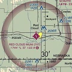
|
| Airport distance calculator |
|---|
|
|
| Sunrise and sunset |
|---|
|
Times for 29-Apr-2025
| | Local
(UTC-5) | | Zulu
(UTC) |
|---|
| Morning civil twilight | | 06:08 | | 11:08 |
| Sunrise | | 06:38 | | 11:38 |
| Sunset | | 20:26 | | 01:26 |
| Evening civil twilight | | 20:55 | | 01:55 |
|
| Current date and time |
|---|
| Zulu (UTC) | 29-Apr-2025 19:07:07 |
|---|
| Local (UTC-5) | 29-Apr-2025 14:07:07 |
|---|
|
| METAR |
|---|
KK82
22nm SW | 291855Z AUTO 05007KT 010V070 10SM CLR 18/03 A3016 RMK AO2 T01760032
|
KHSI
31nm N | 291853Z AUTO 08008KT 10SM CLR 16/00 A3016 RMK AO2 SLP211 T01610000
|
KPHG
41nm SW | 291855Z AUTO 08006KT 10SM CLR 17/00 A3016 RMK AO2
|
KHDE
42nm NW | 291855Z AUTO 00000KT 10SM CLR 16/00 A3014 RMK AO2 LTG DSNT S T01630000
|
KEAR
43nm NW | 291856Z AUTO 00000KT 10SM CLR 16/00 A3016 RMK AO2 SLP210 T01610000
|
KHJH
44nm E | 291855Z AUTO 04007KT 350V070 10SM CLR 17/M02 A3015 RMK AO2 LTG DSNT S T01701023
|
|
| TAF |
|---|
KEAR
43nm NW | 291740Z 2918/3018 04005KT P6SM SKC FM292300 12007KT P6SM SKC PROB30 3006/3012 4SM -SHRA BKN035 FM301200 13006KT P6SM VCSH FEW015 BKN035
|
|
| NOTAMs |
|---|
NOTAMs are issued by the DoD/FAA and will open in a separate window not controlled by AirNav.
|
|


