FAA INFORMATION EFFECTIVE 17 APRIL 2025
Location
| FAA Identifier: | 9A4 |
| Lat/Long: | 34-39-29.3700N 087-20-54.8090W
34-39.489500N 087-20.913483W
34.6581583,-87.3485581
(estimated) |
| Elevation: | 588 ft. / 179 m (estimated) |
| Variation: | 03W (2015) |
| From city: | 2 miles NE of COURTLAND, AL |
| Time zone: | UTC -5 (UTC -6 during Standard Time) |
| Zip code: | 35618 |
Airport Operations
| Airport use: | Open to the public |
| Activation date: | 12/1986 |
| Control tower: | no |
| ARTCC: | MEMPHIS CENTER |
| FSS: | ANNISTON FLIGHT SERVICE STATION |
| NOTAMs facility: | ANB (NOTAM-D service available) |
| Attendance: | UNATNDD |
| Wind indicator: | lighted |
| Segmented circle: | no |
| Lights: | HIRL RWY 13/31 PRESET LOW INTST, TO INCR INTST - CTAF. NO TWY LGTS. |
| Beacon: | white-green (lighted land airport)
Operates sunset to sunrise. |
Airport Communications
| CTAF/UNICOM: | 122.7 |
| WX AWOS-3P: | 118.525 (256-637-0903) |
| HUNTSVILLE APPROACH: | 118.05 |
| HUNTSVILLE DEPARTURE: | 118.05 |
| WX ASOS at MSL (14 nm W): | 119.425 (256-383-2304) |
| WX ASOS at DCU (20 nm E): | 118.375 (256-350-4270) |
- APCH/DEP SVC PRVDD BY MEMPHIS ARTCC ON FREQS 120.8/307.0 (HUNTSVILLE RCAG) WHEN HUNTSVILLE APCH CTL CLSD.
Nearby radio navigation aids
| VOR radial/distance | | VOR name | | Freq | | Var |
|---|
| RQZr255/36.2 | | ROCKET VORTAC | | 112.20 | | 02E |
Airport Services
| Fuel available: | 100LL
100LL:100LL FUEL AVBL 24/7 WITH CC. |
| Parking: | tiedowns |
| Airframe service: | NONE |
| Powerplant service: | NONE |
| Bottled oxygen: | NONE |
Runway Information
Runway 13/31
| Dimensions: | 4994 x 100 ft. / 1522 x 30 m |
| Surface: | concrete, in poor condition
CONC BLOCKS/JOINTS UNEVEN AT APCH END RWY 31. |
| Runway edge lights: | high intensity |
| RUNWAY 13 | | RUNWAY 31 |
| Latitude: | 34-39.690045N | | 34-39.161165N |
| Longitude: | 087-21.223450W | | 087-20.459938W |
| Elevation: | 581.5 ft. | | 571.7 ft. |
| Traffic pattern: | left | | left |
| Runway heading: | 133 magnetic, 130 true | | 313 magnetic, 310 true |
| Markings: | nonprecision, in fair condition | | nonprecision, in fair condition |
| Runway end identifier lights: | no | | no |
| Touchdown point: | yes, no lights | | yes, no lights |
Runway 18/36
| Dimensions: | 3484 x 150 ft. / 1062 x 46 m |
| Surface: | concrete, in poor condition
SVRL CONC BLOCKS/JOINTS ARE UNEVEN 200 FT FM PAVEMENT END OF RWY 36. POTHOLES AND LOOSE CHUNKS OF CONC PRESENT ON RWY 18/36. |
| Runway edge markings: | RWY 36 MARKINGS FADED. |
| RUNWAY 18 | | RUNWAY 36 |
| Latitude: | 34-39.867167N | | 34-39.295000N |
| Longitude: | 087-21.046833W | | 087-20.986000W |
| Elevation: | 588.0 ft. | | 580.2 ft. |
| Traffic pattern: | left | | left |
| Runway heading: | 178 magnetic, 175 true | | 358 magnetic, 355 true |
| Markings: | basic, in fair condition | | basic, in poor condition |
| Touchdown point: | yes, no lights | | yes, no lights |
Airport Ownership and Management from official FAA records
| Ownership: | Publicly-owned |
| Owner: | LAWRENCE COUNTY COMMISSION
P. O. BOX 307
MOULTON, AL 35650
Phone 256-974-0663 |
| Manager: | GLENN REIST
52 AIR FORCE STREET
COURTLAND, AL 35618
Phone 256-318-4536 |
Additional Remarks
| - | FOR CD CTC HUNTSVILLE APCH AT 256-542-2070, WHEN APCH CLSD CTC MEMPHIS ARTCC AT 901-368-8453/8449. |
| - | PORTIONS OF RAMP ARE IN POOR COND WITH LOOSE CHUNKS OF CONC AND VEGETATION GROWTH. |
| - | TWYS POOR COND WITH LOOSE CONC CRACKING AND VEGETATION GROWTH. |
Instrument Procedures
NOTE: All procedures below are presented as PDF files. If you need a reader for these files, you should download the free Adobe Reader.NOT FOR NAVIGATION. Please procure official charts for flight.
FAA instrument procedures published for use from 17 April 2025 at 0901Z to 15 May 2025 at 0900z.
IAPs - Instrument Approach Procedures |
|---|
| RNAV (GPS) RWY 13 | |
download (256KB) |
| RNAV (GPS) RWY 31 | |
download (235KB) |
| NOTE: Special Alternate Minimums apply | |
download (154KB) |
| NOTE: Special Take-Off Minimums/Departure Procedures apply | |
download (316KB) |
Other nearby airports with instrument procedures:
KMSL - Northwest Alabama Regional Airport (14 nm W)
KDCU - Pryor Field Regional Airport (20 nm E)
M22 - Bill Pugh Field Airport (22 nm SW)
5M0 - Hartselle/Morgan County Regional Airport (25 nm SE)
1M4 - Posey Field Airport (26 nm SW)
|
|

Road maps at:
MapQuest
Bing
Google
| Aerial photo |
|---|
WARNING: Photo may not be current or correct

Do you have a better or more recent aerial photo of Courtland Airport that you would like to share? If so, please send us your photo.
|
| Sectional chart |
|---|
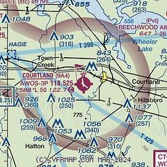
|
| Airport distance calculator |
|---|
|
|
| Sunrise and sunset |
|---|
|
Times for 01-May-2025
| | Local
(UTC-5) | | Zulu
(UTC) |
|---|
| Morning civil twilight | | 05:33 | | 10:33 |
| Sunrise | | 06:00 | | 11:00 |
| Sunset | | 19:33 | | 00:33 |
| Evening civil twilight | | 20:00 | | 01:00 |
|
| Current date and time |
|---|
| Zulu (UTC) | 01-May-2025 14:50:39 |
|---|
| Local (UTC-5) | 01-May-2025 09:50:39 |
|---|
|
| METAR |
|---|
| K9A4 | 011435Z AUTO RMK AO2 PWINO
|
KMSL
14nm NW | 011353Z AUTO 19014KT 10SM CLR 23/15 A2997 RMK AO2 SLP143 T02330150
|
KDCU
20nm E | 011353Z AUTO 18013KT 10SM CLR 24/17 A3002 RMK AO2 SLP157 T02390172
|
|
| TAF |
|---|
KMSL
14nm NW | 011150Z 0112/0212 18005KT P6SM FEW030 BKN250 FM011400 22010G20KT P6SM VCSH SCT025 SCT080 BKN200 PROB30 0118/0123 4SM TSRA BR BKN025CB FM020100 21005KT P6SM SCT040 BKN150 FM020600 VRB03KT P6SM BKN250
|
|
| NOTAMs |
|---|
NOTAMs are issued by the DoD/FAA and will open in a separate window not controlled by AirNav.
|
|


