FAA INFORMATION EFFECTIVE 17 APRIL 2025
Location
| FAA Identifier: | C02 |
| Lat/Long: | 42-36-52.8590N 088-23-23.9520W
42-36.880983N 088-23.399200W
42.6146831,-88.3899867
(estimated) |
| Elevation: | 835.4 ft. / 255 m (estimated) |
| Variation: | 04W (2020) |
| From city: | 2 miles ENE of LAKE GENEVA, WI |
| Time zone: | UTC -5 (UTC -6 during Standard Time) |
| Zip code: | 53147 |
Airport Operations
| Airport use: | CLOSED INDEFINITELY |
| Activation date: | 02/1998 |
| Control tower: | no |
| ARTCC: | CHICAGO CENTER |
| FSS: | GREEN BAY FLIGHT SERVICE STATION |
| NOTAMs facility: | GRB (NOTAM-D service available) |
| Attendance: | UNATNDD |
| Wind indicator: | lighted |
| Segmented circle: | yes |
| Lights: | MIRL RY 05/23 PRESET ON MED INTST SS-SR. |
Airport Communications
| CTAF/UNICOM: | 122.8 |
| MILWAUKEE APPROACH: | 135.875 |
| MILWAUKEE DEPARTURE: | 135.875 |
| WX AWOS-3 at BUU (6 nm NE): | 125.275 (262-757-0907) |
| WX AWOS-3PT at 57C (11 nm N): | 118.125 (262-642-1845) |
Nearby radio navigation aids
| VOR radial/distance | | VOR name | | Freq | | Var |
|---|
| BAEr187/30.5 | | BADGER VOR/DME | | 116.40 | | 02E |
| OBKr323/30.6 | | NORTHBROOK VOR/DME | | 113.00 | | 02W |
| JVLr081/31.8 | | JANESVILLE VOR/DME | | 114.30 | | 03E |
| NDB name | | Hdg/Dist | | Freq | | Var | | ID |
|---|
| ROCK RIVER | | 157/36.6 | | 371 | | 01W | | RYV | .-. -.-- ...- |
Airport Services
| Parking: | tiedowns |
| Airframe service: | NONE |
| Powerplant service: | NONE |
| Bottled oxygen: | NONE |
| Bulk oxygen: | NONE |
Runway Information
Runway 5/23
| Dimensions: | 4100 x 75 ft. / 1250 x 23 m |
| Surface: | asphalt, in poor condition
EXTENSIVE CRACKING ENTIRE RY. |
| Runway edge lights: | medium intensity |
| Runway edge markings: | MRKGS FADED. |
| RUNWAY 5 | | RUNWAY 23 |
| Latitude: | 42-36.678167N | | 42-37.083772N |
| Longitude: | 088-23.764500W | | 088-23.033870W |
| Elevation: | 834.5 ft. | | 834.7 ft. |
| Traffic pattern: | right | | left |
| Runway heading: | 057 magnetic, 053 true | | 237 magnetic, 233 true |
| Markings: | nonprecision, in poor condition | | nonprecision, in poor condition |
| Touchdown point: | yes, no lights | | yes, no lights |
| Obstructions: | 15 ft. road, 200 ft. from runway, 50 ft. left and right of centerline
ROADS 0-200 FT FM RWY END, 50 L/R. | | 50 ft. trees, 200 ft. from runway, 150 ft. left of centerline
30-50 FT TREES 0-200 FT FM THR. |
Airport Ownership and Management from official FAA records
| Ownership: | Privately-owned |
| Owner: | GRAND GENEVA RESORT
7036 GRAND GENEVA WAY
LAKE GENEVA, WI 53147-0130
Phone 262-249-7905 |
| Manager: | JIM CROTHERS
7036 GRAND GENEVA WAY
LAKE GENEVA, WI 53147-0130
Phone 262-249-4738 |
Additional Remarks
| - | FOR NOISE ABATEMENT USE RY 23. |
| - | ARPT CLSD DEC 1 THRU APR 5, UFN. |
| - | FOR CD CTC CHICAGO ARTCC AT 630-906-8921. |
| - | (ARPT STATUS) ARPT CLSD INDEFLY. |
Instrument Procedures
NOTE: All procedures below are presented as PDF files. If you need a reader for these files, you should download the free Adobe Reader.NOT FOR NAVIGATION. Please procure official charts for flight.
FAA instrument procedures published for use from 17 April 2025 at 0901Z to 15 May 2025 at 0900z.
IAPs - Instrument Approach Procedures |
|---|
| RNAV (GPS) RWY 23 | |
download (183KB) |
| NOTE: Special Take-Off Minimums/Departure Procedures apply | |
download (384KB) |
Other nearby airports with instrument procedures:
KBUU - Burlington Municipal Airport (6 nm NE)
57C - East Troy Municipal Airport (11 nm N)
10C - Galt Field Airport (13 nm S)
KENW - Kenosha Regional Airport (20 nm E)
C81 - Campbell Airport (22 nm SE)
|
|

Road maps at:
MapQuest
Bing
Google
| Aerial photo |
|---|
WARNING: Photo may not be current or correct
 Photo by Jeff Koon
Photo taken 22-Aug-2010
looking South.
Photo by Jeff Koon
Photo taken 22-Aug-2010
looking South.
Do you have a better or more recent aerial photo of Grand Geneva Resort Airport that you would like to share? If so, please send us your photo.
|
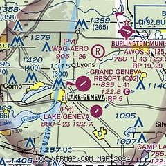
| Sectional chart |
|---|
|
| Airport distance calculator |
|---|
|
|
| Sunrise and sunset |
|---|
|
Times for 23-Apr-2025
| | Local
(UTC-5) | | Zulu
(UTC) |
|---|
| Morning civil twilight | | 05:31 | | 10:31 |
| Sunrise | | 06:01 | | 11:01 |
| Sunset | | 19:43 | | 00:43 |
| Evening civil twilight | | 20:13 | | 01:13 |
|
| Current date and time |
|---|
| Zulu (UTC) | 24-Apr-2025 00:34:55 |
|---|
| Local (UTC-5) | 23-Apr-2025 19:34:55 |
|---|
|
| METAR |
|---|
KBUU
6nm NE | 232355Z AUTO 21004KT 10SM SCT100 A3009 RMK AO2 PWINO
|
K57C
11nm N | 232355Z AUTO 00000KT 10SM SCT100 SCT120 21/12 A3008 RMK AO2 LTG DSNT N T02050115 10219 20168
|
|
| TAF |
|---|
KENW
20nm E | 232239Z 2323/2418 12007KT P6SM SCT100 FM240200 VRB04KT P6SM SCT110 FM241400 05005KT P6SM BKN230 FM241600 06007KT P6SM SCT240
|
|
| NOTAMs |
|---|
NOTAMs are issued by the DoD/FAA and will open in a separate window not controlled by AirNav.
|
|


