FAA INFORMATION EFFECTIVE 17 APRIL 2025
Location
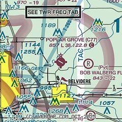
| FAA Identifier: | C77 |
| Lat/Long: | 42-19-22.3000N 088-50-10.7000W
42-19.371667N 088-50.178333W
42.3228611,-88.8363056
(estimated) |
| Elevation: | 857.4 ft. / 261.3 m (surveyed) |
| Variation: | 03W (2025) |
| From city: | 3 miles S of POPLAR GROVE, IL |
| Time zone: | UTC -5 (UTC -6 during Standard Time) |
| Zip code: | 61065 |
Airport Operations
| Airport use: | Open to the public |
| Activation date: | 10/1972 |
| Control tower: | no |
| ARTCC: | CHICAGO CENTER |
| FSS: | KANKAKEE FLIGHT SERVICE STATION |
| NOTAMs facility: | IKK (NOTAM-D service available) |
| Attendance: | SR-SS |
| Wind indicator: | lighted |
| Segmented circle: | no |
| Lights: | SS-SR |
| Beacon: | white-green (lighted land airport)
Operates sunset to sunrise. |
Airport Communications
| CTAF/UNICOM: | 122.8 |
| ROCKFORD APPROACH: | 121.0 |
| ROCKFORD DEPARTURE: | 121.0 |
| WX ASOS at RFD (14 nm SW): | PHONE 224-634-4737 |
Nearby radio navigation aids
| VOR radial/distance | | VOR name | | Freq | | Var |
|---|
| JVLr137/18.5 | | JANESVILLE VOR/DME | | 114.30 | | 03E |
| DPAr318/33.8 | | DUPAGE VOR/DME | | 108.40 | | 02E |
| OBKr281/39.7 | | NORTHBROOK VOR/DME | | 113.00 | | 02W |
Airport Services
| Fuel available: | 100LL |
| Parking: | hangars and tiedowns |
| Airframe service: | MAJOR |
| Powerplant service: | MAJOR |
| Bottled oxygen: | NONE |
| Bulk oxygen: | NONE |
Runway Information
Runway 12/30
| Dimensions: | 3773 x 50 ft. / 1150 x 15 m |
| Surface: | asphalt/aggregate friction seal coat, in good condition |
| Runway edge lights: | low intensity
NSTD LIRL DUE TO SPACING, INTST & NON-FRANGIBLE MOUNTINGS. |
| RUNWAY 12 | | RUNWAY 30 |
| Latitude: | 42-19.441592N | | 42-19.107633N |
| Longitude: | 088-50.558168W | | 088-49.852350W |
| Elevation: | 855.5 ft. | | 850.2 ft. |
| Traffic pattern: | left | | left |
| Runway heading: | 126 magnetic, 123 true | | 306 magnetic, 303 true |
| Displaced threshold: | 500 ft.
MKD WITH WHITE BARS UNDER NUMBERS; NO ARROWS. | | no |
| Markings: | basic, in poor condition | | basic, in poor condition |
| Runway end identifier lights: | no | | no |
| Touchdown point: | yes, no lights | | no, no lights |
Runway 9/27
| Dimensions: | 2709 x 200 ft. / 826 x 61 m |
| Surface: | turf, in good condition |
| Operational restrictions: | CLSD WHEN SNOW COVERED EXCP TO SKI ACFT. |
| RUNWAY 9 | | RUNWAY 27 |
| Latitude: | 42-19.424975N | | 42-19.424418N |
| Longitude: | 088-50.513113W | | 088-49.912037W |
| Elevation: | 857.4 ft. | | 849.0 ft. |
| Traffic pattern: | left | | left |
| Runway heading: | 093 magnetic, 090 true | | 273 magnetic, 270 true |
| Runway end identifier lights: | no | | no |
| Obstructions: | none | | 62 ft. tree, 655 ft. from runway, 155 ft. right of centerline, 10:1 slope to clear |
Runway 17/35
| Dimensions: | 2467 x 150 ft. / 752 x 46 m |
| Surface: | turf, in good condition |
| Operational restrictions: | CLSD WHEN SNOW COVERED EXCP TO SKI ACFT. |
| RUNWAY 17 | | RUNWAY 35 |
| Latitude: | 42-19.664697N | | 42-19.259728N |
| Longitude: | 088-50.121875W | | 088-50.081482W |
| Elevation: | 850.0 ft. | | 848.7 ft. |
| Traffic pattern: | left | | left |
| Runway heading: | 179 magnetic, 176 true | | 359 magnetic, 356 true |
| Displaced threshold: | 220 ft.
MKD WITH THREE CONES ON EACH SIDE OF RWY. | | no |
| Obstructions: | 17 ft. road
APCH SLOPE IS 20:1 AT DSPLCD THR. | | none |
Airport Ownership and Management from official FAA records
| Ownership: | Privately-owned |
| Owner: | STEVE THOMAS
11619 RTE 76
POPLAR GROVE, IL 61065
Phone 815-544-3471
ALT BLAKE THOMAS |
| Manager: | BKAKE . THOMAS
11619 RT 76
POPLAR GROVE, IL 61065
Phone 815-544-3471
EMAIL ADDRESS: STEVE@POPLARGROVEAIRMOTIVE.COM (ALL LOWER CASE) |
Additional Remarks
| A30A-30 | CALM WIND RWY. |
| A57-12 | APCH SLOPE IS 32:1 AT DSPLCD THR. |
| - | CAUTION: IMPAIRED SIGHT CLNCS BTN RWY ENDS DUE TO ROLLING TRRN. |
| - | FOR CD CTC CHICAGO ARTCC AT 630-906-8921. |
| - | RWY 12/30 MARKINGS POOR. |
Instrument Procedures
NOTE: All procedures below are presented as PDF files. If you need a reader for these files, you should download the free Adobe Reader.NOT FOR NAVIGATION. Please procure official charts for flight.
FAA instrument procedures published for use from 17 April 2025 at 0901Z to 15 May 2025 at 0900z.
IAPs - Instrument Approach Procedures |
|---|
| RNAV (GPS)-A | |
download (184KB) |
| NOTE: Special Take-Off Minimums/Departure Procedures apply | |
download (201KB) |
Other nearby airports with instrument procedures:
44C - Beloit Airport (12 nm NW)
KRFD - Chicago/Rockford International Airport (14 nm SW)
KJVL - Southern Wisconsin Regional Airport (20 nm NW)
10C - Galt Field Airport (21 nm E)
3CK - Lake in the Hills Airport (24 nm E)
|
|

Road maps at:
MapQuest
Bing
Google
| Aerial photo |
|---|
WARNING: Photo may not be current or correct
 Photo taken 25-Jul-2020
Do you have a better or more recent aerial photo of Poplar Grove Airport that you would like to share? If so, please send us your photo.
|
| Sectional chart |
|---|
|
| Airport distance calculator |
|---|
|
|
| Sunrise and sunset |
|---|
|
Times for 02-May-2025
| | Local
(UTC-5) | | Zulu
(UTC) |
|---|
| Morning civil twilight | | 05:19 | | 10:19 |
| Sunrise | | 05:50 | | 10:50 |
| Sunset | | 19:54 | | 00:54 |
| Evening civil twilight | | 20:25 | | 01:25 |
|
| Current date and time |
|---|
| Zulu (UTC) | 02-May-2025 21:44:53 |
|---|
| Local (UTC-5) | 02-May-2025 16:44:53 |
|---|
|
| METAR |
|---|
KRFD
14nm SW | 022054Z VRB04KT 10SM SCT026 BKN055 OVC070 16/09 A2987 RMK AO2 SLP117 T01610094 58004 $
|
KJVL
19nm NW | 022045Z 08007KT 10SM BKN019 14/09 A2987
|
KDKB
24nm S | 022135Z AUTO 08007KT 10SM SCT022 SCT027 SCT033 15/10 A2987 RMK AO2 T01460101
|
|
| TAF |
|---|
KRFD
14nm SW | 021932Z 0220/0318 VRB05KT P6SM VCSH SCT025 BKN045 FM030200 03009KT P6SM OVC015 PROB30 0305/0311 4SM -RA BR BKN008
|
KJVL
19nm NW | 022002Z 0220/0318 06007KT P6SM BKN015 OVC022 PROB30 0220/0224 6SM -SHRA OVC020 FM030000 30005KT P6SM SCT025 OVC030 FM030300 07007KT P6SM BKN017 OVC023 FM031600 05010KT P6SM SCT023 OVC035
|
|
| NOTAMs |
|---|
NOTAMs are issued by the DoD/FAA and will open in a separate window not controlled by AirNav.
|
|


