FAA INFORMATION EFFECTIVE 23 JANUARY 2025
Location
| FAA Identifier: | D17 |
| Lat/Long: | 38-45-30.5000N 108-08-54.5000W
38-45.508333N 108-08.908333W
38.7584722,-108.1484722
(estimated) |
| Elevation: | 5000 ft. / 1524 m (estimated) |
| Variation: | 12E (1990) |
| From city: | 4 miles W of DELTA, CO |
| Time zone: | UTC -7 (UTC -6 during Daylight Saving Time) |
| Zip code: | 81416 |
Airport Operations
| Airport use: | Open to the public |
| Activation date: | 03/1994 |
| Control tower: | no |
| ARTCC: | DENVER CENTER |
| FSS: | DENVER FLIGHT SERVICE STATION |
| NOTAMs facility: | DEN (NOTAM-D service available) |
| Attendance: | 0800-1700 |
| Wind indicator: | yes |
| Segmented circle: | no |
Airport Communications
| CTAF/UNICOM: | 122.8 |
| WX AWOS-3 at AJZ (4 nm E): | 134.0 (970-874-3251) |
| WX ASOS at MTJ (19 nm SE): | 135.225 (970-249-1534) |
Nearby radio navigation aids
| VOR radial/distance | | VOR name | | Freq | | Var |
|---|
| MTJr310/19.1 | | MONTROSE VOR/DME | | 117.10 | | 12E |
| JNCr106/35.1 | | GRAND JUNCTION VOR/DME | | 112.40 | | 15E |
Airport Services
Runway Information
Runway 4/22
| Dimensions: | 4100 x 40 ft. / 1250 x 12 m |
| Surface: | asphalt, in fair condition |
| Operational restrictions: | CLSD TO ACFT 8,500 LBS OR MORE. |
| RUNWAY 4 | | RUNWAY 22 |
| Latitude: | 38-45.319500N | | 38-45.693000N |
| Longitude: | 108-09.142167W | | 108-08.423167W |
| Traffic pattern: | left | | left |
| Markings: | , in fair condition | | , in fair condition |
| Obstructions: | none
HAS +10 FT TREES 25 FT LEFT OF RY AT THLD. | | 70 ft. trees, 505 ft. from runway, 135 ft. left of centerline, 4:1 slope to clear
10 FT ROAD 100 FT FM THLD ON BOTH SIDES; 15 FT SHED 150 FT FM THLD 60 FT LEFT OF CNTRLN. |
Runway 13/31
| Dimensions: | 2000 x 70 ft. / 610 x 21 m
RY END COORDINATES: RY 13: 38 45 37.77 N 108 09 15.96 W RY 31: 38 45 22.28 N 108 09 03.23 W |
| Surface: | gravel/dirt, in fair condition |
| RUNWAY 13 | | RUNWAY 31 |
| Latitude: | 38-45.648667N | | 38-45.371667N |
| Longitude: | 108-09.278000W | | 108-09.049833W |
| Traffic pattern: | left | | left |
| Obstructions: | 12 ft. hill, 110 ft. from runway, 9:1 slope to clear | | 15 ft. road, 225 ft. from runway, 15:1 slope to clear |
Airport Ownership and Management from official FAA records
| Ownership: | Privately-owned |
| Owner: | WESTWINDS ASSOCIATION, INC.
1193 HWY 50, SUITE 101, 1156 MUSTANG LANE
DELTA, CO 81416
Phone 303-829-1696 |
| Manager: | TOM THOENSEN
1193 HWY 50, SUITE 101, 1156 MUSTANG LANE
DELTA, CO 81416
Phone 303-829-1696 |
Additional Remarks
| A30A-13 | RY 13 END CORRDINATES: 38 45 37.8 N 108 09 16.0 S |
| A30A-31 | RY 31 END COORDINATES: 38 45 22.3 N 108 09 03.2 S |
| - | +100 TO 300 FT MOUNTAINS LCTD NORTH; WEST & EAST OF ARPT AT VARYING DISTANCES. |
| - | RY 31 HAS +10 FT TREES 150 FT FM THLD OB; +40 FT TREE 600 FT FM THLD 50 FT R OF CNTRLN. |
| - | FOR CD CTC DENVER ARTCC AT 303-651-4257. |
| - | WILDLIFE ON AND INVOF ARPT. |
| - | RY 22 HAS 180 FT MOUNTAIN 1500 FT FROM RY END, APPCH SLOPE 7:1. |
| - | RY 4 HAS +120 FT TERRAIN 2700 FT FM THLD 380 FT L OF CNTRLN. |
| - | RY 13/31 SOFT WHEN WET. |
Instrument Procedures
There are no published instrument procedures at D17.
Some nearby airports with instrument procedures:
KAJZ - Blake Field Airport (4 nm E)
KMTJ - Montrose Regional Airport (19 nm SE)
KGJT - Grand Junction Regional Airport (28 nm NW)
KAIB - Hopkins Field Airport (37 nm SW)
KTEX - Telluride Regional Airport (50 nm S)
|
|

Road maps at:
MapQuest
Bing
Google
| Aerial photo |
|---|
WARNING: Photo may not be current or correct

Do you have a better or more recent aerial photo of Westwinds Airport that you would like to share? If so, please send us your photo.
|
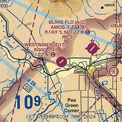
| Sectional chart |
|---|
|
| Airport distance calculator |
|---|
|
|
| Sunrise and sunset |
|---|
|
Times for 11-Feb-2025
| | Local
(UTC-7) | | Zulu
(UTC) |
|---|
| Morning civil twilight | | 06:42 | | 13:42 |
| Sunrise | | 07:09 | | 14:09 |
| Sunset | | 17:44 | | 00:44 |
| Evening civil twilight | | 18:12 | | 01:12 |
|
| Current date and time |
|---|
| Zulu (UTC) | 11-Feb-2025 20:15:19 |
|---|
| Local (UTC-7) | 11-Feb-2025 13:15:19 |
|---|
|
| METAR |
|---|
KAJZ
4nm NE | 111955Z AUTO 21008G17KT 10SM SCT100 09/M12 A2956 RMK AO2 T00901120
|
KMTJ
19nm SE | 111953Z AUTO 22023G34KT 8SM CLR 08/M15 A2956 RMK AO2 PK WND 21034/1946 SLP996 T00831150
|
|
| TAF |
|---|
KMTJ
19nm SE | 111724Z 1118/1218 26014G24KT P6SM SCT090 BKN150 FM120200 29013G24KT P6SM VCSH BKN040 FM120500 28020G30KT 6SM -SHSN BR OVC035 FM120800 31012KT P6SM SCT035 BKN045 FM121200 31005KT P6SM OVC050
|
|
| NOTAMs |
|---|
NOTAMs are issued by the DoD/FAA and will open in a separate window not controlled by AirNav.
|
|


