FAA INFORMATION EFFECTIVE 17 APRIL 2025
Location
| FAA Identifier: | K91 |
| Lat/Long: | 39-40-43.8491N 095-32-03.1630W
39-40.730818N 095-32.052717W
39.6788470,-95.5342119
(estimated) |
| Elevation: | 1134 ft. / 346 m (estimated) |
| Variation: | 06E (1985) |
| From city: | 1 mile NW of HORTON, KS |
| Time zone: | UTC -5 (UTC -6 during Standard Time) |
| Zip code: | 66439 |
Airport Operations
| Airport use: | Open to the public |
| Activation date: | 07/1949 |
| Control tower: | no |
| ARTCC: | KANSAS CITY CENTER |
| FSS: | WICHITA FLIGHT SERVICE STATION |
| NOTAMs facility: | ICT (NOTAM-D service available) |
| Attendance: | UNATNDD
FOR SVC - AMGR OR 785-486-2684. |
| Wind indicator: | lighted |
| Segmented circle: | yes |
Airport Communications
| CTAF: | 122.9 |
| WX AWOS-3PT at K59 (18 nm E): | 123.675 (913-367-1449) |
| WX AWOS-3P at K83 (18 nm NW): | 118.475 (785-284-2201) |
Nearby radio navigation aids
| VOR radial/distance | | VOR name | | Freq | | Var |
|---|
| TOPr356/32.5 | | TOPEKA VORTAC | | 117.80 | | 05E |
| STJr231/32.8 | | ST JOSEPH VORTAC | | 115.50 | | 08E |
| NDB name | | Hdg/Dist | | Freq | | Var | | ID |
|---|
| AMAZON | | 243/31.4 | | 233 | | 04E | | AZN | .- --.. -. |
Airport Services
Runway Information
Runway 17/35
| Dimensions: | 2223 x 100 ft. / 678 x 30 m |
| Surface: | turf, in good condition |
| Runway edge markings: | BDRY; 3 X 5 YELLOW CONC PADS. |
| RUNWAY 17 | | RUNWAY 35 |
| Latitude: | 39-40.900667N | | 39-40.534333N |
| Longitude: | 095-32.098000W | | 095-32.106000W |
| Elevation: | 1113.0 ft. | | 1098.0 ft. |
| Traffic pattern: | left | | left |
| Runway heading: | 175 magnetic, 181 true | | 355 magnetic, 001 true |
| Obstructions: | 20 ft. tree, marked, 10 ft. from runway, 10 ft. right of centerline
CTLG OBSTN EXCEEDS 45 DEG SLP. | | 15 ft. road, 10 ft. from runway |
Runway 15/33
| Dimensions: | 1636 x 100 ft. / 499 x 30 m |
| Surface: | turf, in good condition |
| Runway edge markings: | BDRY; 3 X 5 YELLOW CONC PADS. |
| RUNWAY 15 | | RUNWAY 33 |
| Latitude: | 39-40.859000N | | 39-40.638833N |
| Longitude: | 095-32.086500W | | 095-31.885000W |
| Elevation: | 1130.0 ft. | | 1104.0 ft. |
| Traffic pattern: | left | | left |
| Runway heading: | 139 magnetic, 145 true | | 319 magnetic, 325 true |
| Obstructions: | 15 ft. road, 305 ft. from runway, 20:1 slope to clear
CTLG OBSTN EXCEEDS 45 DEG SLP. | | 4 ft. fence, marked, 10 ft. from runway |
Airport Ownership and Management from official FAA records
| Ownership: | Publicly-owned |
| Owner: | CITY OF HORTON
PO BOX 30
HORTON, KS 66439
Phone 785-486-2681 |
| Manager: | JOHN CALHOON
202 E. 8TH STREET
HORTON, KS 66439
Phone 785-486-2681 |
Additional Remarks
| A30A-33 | +150 FT UNLGT ANT ON WTR TWR 3684 FT SE OF APCH END. |
| - | APT FAC & SNOW REMOVAL NA. |
| - | TIEDOWN AREA & TWY UNMKD; ROUGH & NOT MNTND. |
| - | FOR CD CTC ST JOSEPH APCH AT 816-236-3035. WHEN ST JOSEPH APCH IS CLSD, CTC KANSAS CITY ARTCC AT 913-254-8508. |
Instrument Procedures
There are no published instrument procedures at K91.
Some nearby airports with instrument procedures:
K59 - Amelia Earhart Airport (18 nm E)
KFNB - Brenner Field Airport (24 nm N)
KSTJ - Rosecrans Memorial Airport (29 nm E)
KFLV - Sherman Army Airfield (34 nm SE)
KTOP - Philip Billard Municipal Airport (37 nm S)
|
|

Road maps at:
MapQuest
Bing
Google
| Aerial photo |
|---|
WARNING: Photo may not be current or correct
 Photo taken 18-Feb-2017
looking south.
Photo taken 18-Feb-2017
looking south.
Do you have a better or more recent aerial photo of Horton Municipal Airport that you would like to share? If so, please send us your photo.
|
| Sectional chart |
|---|
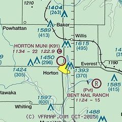
|
| Airport distance calculator |
|---|
|
|
| Sunrise and sunset |
|---|
|
Times for 21-Apr-2025
| | Local
(UTC-5) | | Zulu
(UTC) |
|---|
| Morning civil twilight | | 06:09 | | 11:09 |
| Sunrise | | 06:37 | | 11:37 |
| Sunset | | 20:05 | | 01:05 |
| Evening civil twilight | | 20:33 | | 01:33 |
|
| Current date and time |
|---|
| Zulu (UTC) | 22-Apr-2025 00:05:13 |
|---|
| Local (UTC-5) | 21-Apr-2025 19:05:13 |
|---|
|
| METAR |
|---|
KFNB
23nm N | 212353Z AUTO 16016G23KT 10SM CLR 22/09 A2989 RMK AO2 SLP120 T02170094 10228 20178 56016
|
KSTJ
29nm E | 212353Z 17014KT 10SM CLR 21/09 A2994 RMK AO2 SLP137 T02060094 10217 20167 56009
|
KTOP
37nm S | 212353Z 15010KT 10SM CLR 21/11 A2993 RMK AO2 SLP132 T02110111 10222 20178 56013 $
|
KLWC
42nm S | 212352Z AUTO 17008KT 10SM CLR 20/11 A2996 RMK AO1 SLP142 T02000106 10222 20167 56009
|
KMCI
43nm SE | 212353Z 20008KT 10SM BKN250 19/11 A2996 RMK AO2 SLP142 T01890106 10206 20161 56007
|
KFOE
45nm S | 212353Z 16011KT 10SM CLR 21/12 A2994 RMK AO2 SLP134 T02060117 10217 20178 56011 $
|
|
| TAF |
|---|
KSTJ
29nm E | 211720Z 2118/2218 18007KT P6SM SKC FM221500 21011KT P6SM SCT250
|
|
| NOTAMs |
|---|
NOTAMs are issued by the DoD/FAA and will open in a separate window not controlled by AirNav.
|
|


