FAA INFORMATION EFFECTIVE 17 APRIL 2025
Location
| FAA Identifier: | AUW |
| Lat/Long: | 44-55-34.6243N 089-37-37.2063W
44-55.577072N 089-37.620105W
44.9262845,-89.6270018
(estimated) |
| Elevation: | 1201 ft. / 366.1 m (surveyed) |
| Variation: | 03W (2015) |
| Time zone: | UTC -5 (UTC -6 during Standard Time) |
| Zip code: | 54403 |
Airport Operations
| Airport use: | Open to the public |
| Activation date: | 11/1937 |
| Control tower: | no |
| ARTCC: | MINNEAPOLIS CENTER |
| FSS: | GREEN BAY FLIGHT SERVICE STATION |
| NOTAMs facility: | AUW (NOTAM-D service available) |
| Attendance: | 0800-1700 |
| Wind indicator: | lighted |
| Segmented circle: | yes |
| Lights: | MIRL RWY 13/31 PRESET TO LOW; TO INCR INTST AND ACTVT REILS RWY 13 & 31; PAPI RWY 13 & 31; MIRL RWY 5/23 - CTAF. |
| Beacon: | white-green (lighted land airport)
Operates sunset to sunrise. |
Airport Communications
| CTAF/UNICOM: | 122.7 |
| WX ASOS: | 125.925 (715-843-7215) |
| WX AWOS-3 at CWA (9 nm S): | 127.45 (715-693-1116) |
| WX AWOS-3 at RRL (17 nm N): | 119.925 (715-539-8422) |
- APCH/DEP SVC PRVDD BY MINNEAPOLIS ARTCC ON FREQS 124.4/317.7 (MOSINEE RCAG).
Airport Services
| Fuel available: | 100LL JET-A+ MOGAS |
| Parking: | hangars and tiedowns |
| Airframe service: | MAJOR |
| Powerplant service: | MAJOR |
Runway Information
Runway 13/31
| Dimensions: | 5200 x 100 ft. / 1585 x 30 m |
| Surface: | asphalt, in fair condition |
| Weight bearing capacity: | | Single wheel: | 45.0 | | Double wheel: | 80.0 | | Double tandem: | 140.0 |
|
| Runway edge lights: | medium intensity |
| RUNWAY 13 | | RUNWAY 31 |
| Latitude: | 44-55.835997N | | 44-55.356667N |
| Longitude: | 089-38.352500W | | 089-37.354667W |
| Elevation: | 1192.1 ft. | | 1190.1 ft. |
| Traffic pattern: | left | | left |
| Runway heading: | 127 magnetic, 124 true | | 307 magnetic, 304 true |
| Markings: | nonprecision, in fair condition | | nonprecision, in fair condition |
| Visual slope indicator: | 4-light PAPI on left (3.00 degrees glide path) | | 4-light PAPI on left (3.00 degrees glide path) |
| Runway end identifier lights: | yes | | yes |
| Touchdown point: | yes, no lights | | yes, no lights |
| Obstructions: | 34 ft. trees, 250 ft. from runway, 410 ft. left of centerline, 1:1 slope to clear
40 FT TREES 0-200 FT FM THR 300 FT R & 450 FT L. | | 38 ft. trees, 225 ft. from runway, 375 ft. left of centerline
30 FT TREES 150 FT FM THR 425 FT L. |
Runway 5/23
| Dimensions: | 3041 x 100 ft. / 927 x 30 m |
| Surface: | asphalt, in fair condition |
| Weight bearing capacity: | | Single wheel: | 32.0 | | Double wheel: | 55.0 | | Double tandem: | 95.0 |
|
| Runway edge lights: | medium intensity |
| RUNWAY 5 | | RUNWAY 23 |
| Latitude: | 44-55.367717N | | 44-55.725195N |
| Longitude: | 089-37.469092W | | 089-36.976205W |
| Elevation: | 1190.4 ft. | | 1201.0 ft. |
| Traffic pattern: | left | | left |
| Runway heading: | 047 magnetic, 044 true | | 227 magnetic, 224 true |
| Markings: | basic, in fair condition | | basic, in fair condition |
| Runway end identifier lights: | no | | no |
| Touchdown point: | yes, no lights | | yes, no lights |
Runway 12W/30W
| Dimensions: | 8000 x 300 ft. / 2438 x 91 m |
| Surface: | water, in good condition |
| RUNWAY 12W | | RUNWAY 30W |
| Latitude: | 44-55.820500N | | 44-55.007333N |
| Longitude: | 089-38.675833W | | 089-37.219333W |
| Elevation: | 1166.0 ft. | | 1166.0 ft. |
| Traffic pattern: | left | | left |
| Markings: | none, in good condition | | none, in good condition |
| Touchdown point: | yes, no lights | | yes, no lights |
Airport Ownership and Management from official FAA records
| Ownership: | Publicly-owned |
| Owner: | CITY OF WAUSAU
407 GRANT ST.
WAUSAU, WI 54403
Phone 715-261-6740 |
| Manager: | JOHN P CHMIEL
725 WOODS PLACE
WAUSAU, WI 54401
Phone 715-845-3400 |
Additional Remarks
| - | FOR CD IF UNA TO CTC ON FSS FREQ, CTC MINNEAPOLIS ARTCC AT 651-463-5588. |
Instrument Procedures
NOTE: All procedures below are presented as PDF files. If you need a reader for these files, you should download the free Adobe Reader.NOT FOR NAVIGATION. Please procure official charts for flight.
FAA instrument procedures published for use from 17 April 2025 at 0901Z to 15 May 2025 at 0900z.
IAPs - Instrument Approach Procedures |
|---|
| RNAV (GPS) RWY 13 | |
download (218KB) |
| RNAV (GPS) RWY 31 | |
download (243KB) |
| NOTE: Special Alternate Minimums apply | |
download (60KB) |
| NOTE: Special Take-Off Minimums/Departure Procedures apply | |
download (424KB) |
Other nearby airports with instrument procedures:
KCWA - Central Wisconsin Airport (9 nm S)
KRRL - Merrill Municipal Airport (17 nm N)
KSTE - Stevens Point Municipal Airport (23 nm S)
KAIG - Langlade County Airport (26 nm NE)
KMFI - Marshfield Municipal Airport (30 nm SW)
|
|

Road maps at:
MapQuest
Bing
Google
| Aerial photo |
|---|
WARNING: Photo may not be current or correct
 Photo by Brian J. Krueger
Taken in October 2006
Photo by Brian J. Krueger
Taken in October 2006
Do you have a better or more recent aerial photo of Wausau Downtown Airport that you would like to share? If so, please send us your photo.
|
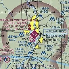
| Sectional chart |
|---|
|
| Airport distance calculator |
|---|
|
|
| Sunrise and sunset |
|---|
|
Times for 20-Apr-2025
| | Local
(UTC-5) | | Zulu
(UTC) |
|---|
| Morning civil twilight | | 05:35 | | 10:35 |
| Sunrise | | 06:06 | | 11:06 |
| Sunset | | 19:49 | | 00:49 |
| Evening civil twilight | | 20:20 | | 01:20 |
|
| Current date and time |
|---|
| Zulu (UTC) | 21-Apr-2025 02:52:24 |
|---|
| Local (UTC-5) | 20-Apr-2025 21:52:24 |
|---|
|
| METAR |
|---|
| KAUW | 210158Z AUTO 06011G20KT 8SM RA FEW007 BKN010 OVC041 04/02 A3001 RMK AO2 P0000 T00440022
|
KCWA
10nm S | 210150Z 09017G23KT 8SM -RA SCT010 BKN016 OVC038 04/03 A3000
|
KRRL
17nm N | 210235Z AUTO 08007KT 4SM RA BKN009 OVC014 04/04 A3001 RMK AO2 P0010 T00380038 TSNO
|
|
| TAF |
|---|
| KAUW | 201720Z 2018/2118 10011G19KT P6SM BKN080 TEMPO 2020/2023 5SM -SHRA SCT035 BKN060 FM202300 12011G18KT P6SM -SHRA OVC035 WS020/11040KT FM210100 08012G21KT 3SM SHRA OVC012 WS020/11040KT FM210400 08014G26KT 3SM SHRA OVC008 WS020/12040KT FM211100 03009G18KT 4SM SHRA BR OVC006 FM211500 32015G25KT P6SM -SHRA BKN014
|
KCWA
10nm S | 201720Z 2018/2118 10011G19KT P6SM BKN080 TEMPO 2020/2024 5SM -SHRA SCT035 BKN060 FM210000 12011G18KT P6SM -SHRA OVC035 WS020/11040KT FM210100 08012G21KT 3SM SHRA OVC011 WS020/11040KT FM210600 08014G26KT 3SM SHRA OVC007 WS020/12040KT FM211100 03009G18KT 4SM SHRA BR OVC006 FM211500 32013G24KT P6SM -SHRA BKN014
|
|
| NOTAMs |
|---|
NOTAMs are issued by the DoD/FAA and will open in a separate window not controlled by AirNav.
|
|


