FAA INFORMATION EFFECTIVE 17 APRIL 2025
Location
| FAA Identifier: | CIU |
| Lat/Long: | 46-15-02.7060N 084-28-20.5830W
46-15.045100N 084-28.343050W
46.2507517,-84.4723842
(estimated) |
| Elevation: | 799.3 ft. / 243.6 m (surveyed) |
| Variation: | 07W (2015) |
| From city: | 15 miles S of SAULT STE MARIE, MI |
| Time zone: | UTC -4 (UTC -5 during Standard Time) |
| Zip code: | 49788 |
Airport Operations
| Airport use: | Open to the public |
| Control tower: | no |
| ARTCC: | TORONTO CENTER |
| FSS: | GREEN BAY FLIGHT SERVICE STATION |
| NOTAMs facility: | CIU (NOTAM-D service available) |
| Attendance: | 0600-1800 |
| Pattern altitude: | 1599.3 ft. MSL |
| Wind indicator: | lighted |
| Segmented circle: | yes |
| Lights: | ACTVT MALSR RWY 16; REIL RWY 34, 10, & 28; PAPI RWY 16, 34, 10, & 28; HIRL RWY 16/34; MIRL RWY 10/28 - CTAF. REIL & PAPI RWY 34 OPR CONSLY DEC-MAR; PAPI RWY 10 & 28 OPR CONSLY DRG DALGT HRS. |
| Beacon: | white-green (lighted land airport)
Operates sunset to sunrise. |
| Fire and rescue: | ARFF index A |
| Airline operations: | 24 HR PPR FOR UNSKED ACR OPS GTR THAN 9 PAX SEATS - CALL AMGR. |
| International operations: | customs landing rights airport |
Airport Communications
| CTAF/UNICOM: | 123.0 |
| WX AWOS-3PT: | 127.575 (906-495-1156) |
| WX ASOS at ANJ (14 nm N): | 118.375 (906-253-9523) |
- APCH/DEP SVC PRVDD BY TORONTO ARTCC ON FREQS 132.65/344.5 (SAULT ENROUTE).
Nearby radio navigation aids
| VOR radial/distance | | VOR name | | Freq | | Var |
|---|
| SSMr218/11.7 | | SAULT STE MARIE VOR/DME | | 112.20 | | 04W |
| PLNr018/38.1 | | PELLSTON VORTAC | | 111.80 | | 06W |
| NDB name | | Hdg/Dist | | Freq | | Var | | ID |
|---|
| KOLOE | | 156/5.7 | | 400 | | 07W | | CI | -.-. .. |
Airport Services
| Fuel available: | 100LL JET-A |
| Parking: | hangars and tiedowns |
| Bottled oxygen: | NONE |
| Bulk oxygen: | NONE |
Runway Information
Runway 16/34
| Dimensions: | 7203 x 150 ft. / 2195 x 46 m |
| Surface: | asphalt/concrete/grooved, in fair condition
CNTR 150 FT IS ASPH, RMNG OUTSIDE EDGES ARE CONC. |
| Weight bearing capacity: | | Single wheel: | 120.0 | | Double wheel: | 215.0 | | Double tandem: | 369.0 | | Dual double tandem: | 855.0 |
|
| Runway edge lights: | high intensity |
| RUNWAY 16 | | RUNWAY 34 |
| Latitude: | 46-15.381202N | | 46-14.354968N |
| Longitude: | 084-28.685732W | | 084-27.831548W |
| Elevation: | 798.5 ft. | | 793.4 ft. |
| Traffic pattern: | right | | left |
| Runway heading: | 157 magnetic, 150 true | | 337 magnetic, 330 true |
| Declared distances: | TORA:7203 TODA:7203 ASDA:7203 LDA:7203 | | TORA:7203 TODA:7203 ASDA:7203 LDA:7203 |
| Markings: | precision, in fair condition | | precision, in fair condition |
| Visual slope indicator: | 4-light PAPI on left (3.00 degrees glide path) | | 4-light PAPI on left (3.00 degrees glide path) |
| Approach lights: | MALSR: 1,400 foot medium intensity approach lighting system with runway alignment indicator lights | | |
| Runway end identifier lights: | no | | yes |
| Touchdown point: | yes, no lights | | yes, no lights |
| Instrument approach: | ILS | | |
Runway 10/28
| Dimensions: | 5001 x 75 ft. / 1524 x 23 m |
| Surface: | asphalt/grooved, in good condition |
| Weight bearing capacity: | | Single wheel: | 55.0 | | Double wheel: | 88.0 | | Double tandem: | 155.0 |
|
| Runway edge lights: | medium intensity |
| RUNWAY 10 | | RUNWAY 28 |
| Latitude: | 46-15.299778N | | 46-15.300312N |
| Longitude: | 084-29.057747W | | 084-27.871747W |
| Elevation: | 791.6 ft. | | 799.3 ft. |
| Traffic pattern: | left | | left |
| Runway heading: | 097 magnetic, 090 true | | 277 magnetic, 270 true |
| Declared distances: | TORA:5000 TODA:5000 ASDA:5000 LDA:5000 | | TORA:5000 TODA:5000 ASDA:5000 LDA:5000 |
| Markings: | nonprecision, in fair condition | | nonprecision, in fair condition |
| Visual slope indicator: | 4-light PAPI on left (3.00 degrees glide path) | | 4-light PAPI on left (3.00 degrees glide path)
PAPI UNUSBL BYD 8 DEGS LEFT OF CNTRLN. |
| Runway end identifier lights: | yes | | yes |
| Touchdown point: | yes, no lights | | yes, no lights |
| Obstructions: | 57 ft. trees, 1900 ft. from runway, 50 ft. left of centerline, 29:1 slope to clear | | 51 ft. trees, 1800 ft. from runway, 200 ft. left of centerline, 31:1 slope to clear |
Airport Ownership and Management from official FAA records
| Ownership: | Publicly-owned |
| Owner: | CHIPPEWA COUNTY ECON DEV CORP
5019 W AIRPORT DR
KINCHELOE, MI 49788-1643
Phone 906-495-5631 |
| Manager: | TAMI L BESEAU
5019 W AIRPORT DR
KINCHELOE, MI 49788-1643
Phone 906-495-5631
AFT HRS CELL 906-322-3651. |
Additional Remarks
| A39-16/34 | PCR VALUE: 680/R/B/W/T |
| A39-10/28 | PCR VALUE: 200/F/B/X/T |
| - | BIRDS ON & INVOF ARPT. |
| - | EXP SNOW REMOVAL ACT DLY DEC-MAR. |
| - | VEHICLE TESTING INPR DRG WINTER MONTHS ON SECTIONS OF CLSD/ABNDD PARL TWY, SE OF APCH END RWY 34. AREA MAY BE PLOWED TO BARE SFC BUT UNAVBL FOR ARR OR DEP. |
| - | FICONS UNMON 2100-0700. |
| - | FOR CD IF UNA TO CTC ON FSS FREQ, CTC MINNEAPOLIS ARTCC AT 651-463-5588. |
Instrument Procedures
NOTE: All procedures below are presented as PDF files. If you need a reader for these files, you should download the free Adobe Reader.NOT FOR NAVIGATION. Please procure official charts for flight.
FAA instrument procedures published for use from 17 April 2025 at 0901Z to 15 May 2025 at 0900z.
IAPs - Instrument Approach Procedures |
|---|
| ILS OR LOC RWY 16 | |
download (259KB) |
| RNAV (GPS) RWY 10 | |
download (225KB) |
| RNAV (GPS) RWY 16 | |
download (222KB) |
| RNAV (GPS) RWY 28 | |
download (230KB) |
| RNAV (GPS) RWY 34 | |
download (242KB) |
| NDB RWY 34 | |
download (215KB) |
| NOTE: Special Alternate Minimums apply | |
download (140KB) |
| NOTE: Special Take-Off Minimums/Departure Procedures apply | |
download (181KB) |
Other nearby airports with instrument procedures:
KANJ - Sault Ste Marie Municipal Airport/Sanderson Field (14 nm N)
KMCD - Mackinac Island Airport (24 nm S)
83D - Mackinac County Airport (24 nm SW)
6Y1 - Bois Blanc Island Airport (29 nm S)
KDRM - Drummond Island Airport (34 nm SE)
|
|

Road maps at:
MapQuest
Bing
Google
| Aerial photo |
|---|
WARNING: Photo may not be current or correct

Do you have a better or more recent aerial photo of Chippewa County International Airport that you would like to share? If so, please send us your photo.
|
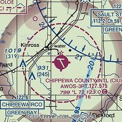
| Sectional chart |
|---|
|
 Download PDF
of official airport diagram from the FAA
| Airport distance calculator |
|---|
|
|
| Sunrise and sunset |
|---|
|
Times for 25-Apr-2025
| | Local
(UTC-4) | | Zulu
(UTC) |
|---|
| Morning civil twilight | | 06:02 | | 10:02 |
| Sunrise | | 06:35 | | 10:35 |
| Sunset | | 20:37 | | 00:37 |
| Evening civil twilight | | 21:10 | | 01:10 |
|
| Current date and time |
|---|
| Zulu (UTC) | 25-Apr-2025 16:59:44 |
|---|
| Local (UTC-4) | 25-Apr-2025 12:59:44 |
|---|
|
| METAR |
|---|
| KCIU | 251556Z AUTO 03008KT 10SM SCT021 OVC060 08/05 A3015 RMK AO2 RAB05E16 SLP217 P0000 T00830050
|
KANJ
14nm N | 251555Z AUTO 06003KT 10SM OVC070 08/04 A3016 RMK AO2 RAB27E50 SLP216 P0000 T00830044
|
CYAM
14nm N | 251600Z 06007KT 20SM OVC073 09/06 A3015 RMK ACC8 ACC MOV E SLP220
|
|
| TAF |
|---|
| KCIU | 251125Z 2512/2612 05005KT 6SM -SHRA BR OVC050 FM251400 06007KT 3SM -SHRA BR OVC012 FM251700 04007KT 4SM -SHRA BR OVC009 FM252300 36009KT 3SM -SHRA BR OVC005 FM260100 36009KT P6SM VCSH OVC006 FM261000 34010G15KT P6SM BKN015
|
CYAM
14nm N | 251340Z 2514/2602 08008KT P6SM OVC060 FM251500 VRB03KT P6SM SCT012 OVC060 TEMPO 2515/2518 P6SM -RA OVC012 FM251800 36005KT P6SM -RA SCT012 OVC030 TEMPO 2518/2520 4SM -RA BR BKN008 OVC012 FM252000 33008KT 4SM -RA BR OVC008 RMK NXT FCST BY 252000Z
|
|
| NOTAMs |
|---|
NOTAMs are issued by the DoD/FAA and will open in a separate window not controlled by AirNav.
|
|


