FAA INFORMATION EFFECTIVE 20 FEBRUARY 2025
Location
| FAA Identifier: | DAF |
| Lat/Long: | 44-02-00.4000N 090-05-06.4000W
44-02.006667N 090-05.106667W
44.0334444,-90.0851111
(estimated) |
| Elevation: | 919.3 ft. / 280.2 m (surveyed) |
| Variation: | 01W (2000) |
| From city: | 1 mile NW of NECEDAH, WI |
| Time zone: | UTC -6 (UTC -5 during Daylight Saving Time) |
| Zip code: | 54646 |
Airport Operations
| Airport use: | Open to the public |
| Activation date: | 12/1965 |
| Control tower: | no |
| ARTCC: | CHICAGO CENTER |
| FSS: | GREEN BAY FLIGHT SERVICE STATION |
| NOTAMs facility: | GRB (NOTAM-D service available) |
| Attendance: | UNATNDD |
| Wind indicator: | lighted |
| Segmented circle: | yes |
| Lights: | ACTVT LIRL RY 18/36 - CTAF. |
| Beacon: | white-green (lighted land airport)
Operates sunset to sunrise. |
Airport Communications
| CTAF/UNICOM: | 122.7 |
| VOLK APPROACH: | 135.25 |
| VOLK DEPARTURE: | 135.25 |
| WX AWOS-3 at 82C (12 nm S): | 123.925 (608-562-6153) |
- APCH/DEP SVC PRVDD BY CHICAGO ARTCC (ZAU) ON FREQS 125.05/269.375 (CAMP DOUGLAS RCAG) WHEN VOLK APCH CTL CLSD.
Nearby radio navigation aids
| VOR radial/distance | | VOR name | | Freq | | Var |
|---|
| DLLr331/32.1 | | DELLS VORTAC | | 117.00 | | 03E |
| NDB name | | Hdg/Dist | | Freq | | Var | | ID |
|---|
| MCCOY | | 077/24.7 | | 412 | | 00E | | CMY | -.-. -- -.-- |
Airport Services
| Parking: | tiedowns |
| Airframe service: | MINOR |
| Powerplant service: | MINOR |
| Bottled oxygen: | NONE |
| Bulk oxygen: | NONE |
Runway Information
Runway 18/36
| Dimensions: | 2721 x 60 ft. / 829 x 18 m |
| Surface: | asphalt, in fair condition |
| Runway edge lights: | low intensity |
| RUNWAY 18 | | RUNWAY 36 |
| Latitude: | 44-02.229990N | | 44-01.782247N |
| Longitude: | 090-05.109360W | | 090-05.104337W |
| Elevation: | 912.0 ft. | | 919.3 ft. |
| Traffic pattern: | left | | left |
| Runway heading: | 180 magnetic, 179 true | | 000 magnetic, 359 true |
| Markings: | nonprecision, in good condition | | nonprecision, in good condition |
| Touchdown point: | yes, no lights | | yes, no lights |
| Obstructions: | 35 ft. trees, 200 ft. from runway, 250 ft. left of centerline, 1:1 slope to clear
35 FT TREES 0 - 200 FT FM RWY END, 237 FT L. | | 15 ft. road, 307 ft. from runway, 264 ft. left of centerline, 7:1 slope to clear |
Airport Ownership and Management from official FAA records
| Ownership: | Publicly-owned |
| Owner: | VILLAGE OF NECEDAH
VILLAGE HALL
NECEDAH, WI 54646
Phone 608-565-2261
EXT 2 |
| Manager: | JACK JASINSKI
W6827 20TH STREET W
NECEDAH, WI 54646
Phone 608-547-3411
EMAIL ADDRESS: NECEDAHADMIN@NECEDAH.US (ALL LOWER CASE) |
Additional Remarks
| - | DURG WINTER MONTHS CALL 608-547-3411 BFR LNDG TO DTRM STATUS. |
| - | FOR CD CTC CHICAGO ARTCC AT 630-906-8921. |
Instrument Procedures
NOTE: All procedures below are presented as PDF files. If you need a reader for these files, you should download the free Adobe Reader.NOT FOR NAVIGATION. Please procure official charts for flight.
FAA instrument procedures published for use from 20 February 2025 at 0901Z to 20 March 2025 at 0900Z.
IAPs - Instrument Approach Procedures |
|---|
| RNAV (GPS) RWY 36 | |
download (211KB) |
| NOTE: Special Take-Off Minimums/Departure Procedures apply | |
download (201KB) |
Other nearby airports with instrument procedures:
KVOK - Volk Field Airport (9 nm SW)
82C - Mauston/New Lisbon Union Airport (12 nm S)
63C - Adams County Airport-Legion Field (14 nm E)
Y72 - Bloyer Field Airport (17 nm W)
KISW - Alexander Field South Wood County Airport (22 nm NE)
|
|

Road maps at:
MapQuest
Bing
Google
| Aerial photo |
|---|

|
| Sectional chart |
|---|
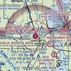
|
| Airport distance calculator |
|---|
|
|
| Sunrise and sunset |
|---|
|
Times for 06-Mar-2025
| | Local
(UTC-6) | | Zulu
(UTC) |
|---|
| Morning civil twilight | | 06:01 | | 12:01 |
| Sunrise | | 06:30 | | 12:30 |
| Sunset | | 17:54 | | 23:54 |
| Evening civil twilight | | 18:23 | | 00:23 |
|
| Current date and time |
|---|
| Zulu (UTC) | 06-Mar-2025 20:27:19 |
|---|
| Local (UTC-6) | 06-Mar-2025 14:27:19 |
|---|
|
| METAR |
|---|
KVOK
11nm SW | 061955Z 24011KT 10SM CLR 02/M08 A2984 RMK AO2A SLP120 T00181078
|
K82C
12nm S | 062015Z AUTO 27006KT 250V310 10SM CLR 02/M08 A2986 RMK AO2 T00211077
|
|
| TAF |
|---|
KVOK
11nm SW | 061700Z 0617/0723 29012KT 9999 SKC QNH2984INS BECMG 0712/0713 05006KT 9999 -SN SCT075 OVC100 621001 QNH2987INS BECMG 0718/0719 07003KT 9999 NSW FEW200 QNH2984INS TX00/0622Z TNM04/0713Z LAST NO AMDS AFT 0621 NEXT 0709
|
|
| NOTAMs |
|---|
NOTAMs are issued by the DoD/FAA and will open in a separate window not controlled by AirNav.
|
|


