FAA INFORMATION EFFECTIVE 17 APRIL 2025
Location
| FAA Identifier: | DLL |
| Lat/Long: | 43-31-19.2920N 089-46-16.4570W
43-31.321533N 089-46.274283W
43.5220256,-89.7712381
(estimated) |
| Elevation: | 980.2 ft. / 298.8 m (surveyed) |
| Variation: | 01W (2000) |
| From city: | 3 miles NW of BARABOO, WI |
| Time zone: | UTC -5 (UTC -6 during Standard Time) |
| Zip code: | 53913 |
Airport Operations
| Airport use: | Open to the public |
| Activation date: | 10/1945 |
| Control tower: | no |
| ARTCC: | CHICAGO CENTER |
| FSS: | GREEN BAY FLIGHT SERVICE STATION |
| NOTAMs facility: | DLL (NOTAM-D service available) |
| Attendance: | MAY-SEP 0800-1900, OCT-APR 0800-1700 |
| Wind indicator: | yes |
| Segmented circle: | yes |
| Lights: | MIRL RWY 01/19 PRESET TO LOW SS-SR; TO INCR INTST & ACTVT REIL RWY 01 & 19; PAPI RWY 01 & 19 - CTAF. |
| Beacon: | white-green (lighted land airport)
Operates sunset to sunrise. |
Airport Communications
| CTAF/UNICOM: | 123.05 |
| WX AWOS-3: | 118.325 (608-356-1071) |
| MADISON APPROACH: | 135.45 |
| MADISON DEPARTURE: | 135.45 |
| WX AWOS-3PT at C35 (9 nm W): | 118.95 (608-768-0023) |
- APCH/DEP SVC PRVDD BY CHICAGO ARTCC ON FREQS 133.3/257.925 (LONE ROCK RCAG) WHEN MADISON APCH CTL CLSD.
Nearby radio navigation aids
| VOR radial/distance | | VOR name | | Freq | | Var |
|---|
| DLLr188/1.8 | | DELLS VORTAC | | 117.00 | | 03E |
| MSNr317/29.4 | | MADISON VORTAC | | 108.60 | | 03E |
Airport Services
| Fuel available: | 100LL JET-A+
100LL:24 HR FUEL AVBL WITH CREDIT CARD. |
| Parking: | hangars and tiedowns |
| Airframe service: | MAJOR |
| Powerplant service: | MAJOR |
| Bottled oxygen: | NONE |
| Bulk oxygen: | NONE |
Runway Information
Runway 1/19
| Dimensions: | 5010 x 100 ft. / 1527 x 30 m |
| Surface: | asphalt, in excellent condition |
| Weight bearing capacity: | | Single wheel: | 30.0 | | Double wheel: | 55.0 |
|
| Runway edge lights: | medium intensity |
| RUNWAY 1 | | RUNWAY 19 |
| Latitude: | 43-30.935962N | | 43-31.750923N |
| Longitude: | 089-46.304850W | | 089-46.132057W |
| Elevation: | 977.0 ft. | | 967.5 ft. |
| Traffic pattern: | left | | left |
| Runway heading: | 010 magnetic, 009 true | | 190 magnetic, 189 true |
| Markings: | nonprecision, in good condition | | nonprecision, in good condition |
| Visual slope indicator: | 2-light PAPI on left (3.00 degrees glide path)
PAPI UNUSBL BYD 8 DEGS LEFT OF CNTRLN. | | 2-light PAPI on left (3.00 degrees glide path) |
| Runway end identifier lights: | yes | | yes |
| Touchdown point: | yes, no lights | | yes, no lights |
| Instrument approach: | LOC/DME | | |
| Obstructions: | none | | 50 ft. trees, 1555 ft. from runway, 290 ft. left of centerline, 27:1 slope to clear |
Runway 14/32
| Dimensions: | 2725 x 100 ft. / 831 x 30 m |
| Surface: | turf, in good condition |
| Runway edge markings: | MKD WITH YELLOW/BLACK A-FRAMES AND YELLOW CONES. |
| RUNWAY 14 | | RUNWAY 32 |
| Latitude: | 43-31.437173N | | 43-31.125310N |
| Longitude: | 089-46.598425W | | 089-46.155403W |
| Elevation: | 971.9 ft. | | 977.2 ft. |
| Traffic pattern: | left | | left |
| Runway heading: | 135 magnetic, 134 true | | 315 magnetic, 314 true |
| Markings: | none | | none |
| Runway end identifier lights: | no | | no |
| Touchdown point: | yes, no lights | | yes, no lights |
| Obstructions: | 85 ft. tree, 1325 ft. from runway, 90 ft. right of centerline, 15:1 slope to clear | | none |
Airport Ownership and Management from official FAA records
| Ownership: | Publicly-owned |
| Owner: | VILLAGE OF LAKE DELTON
PO BOX 50
LAKE DELTON, WI 53940
Phone 608-254-2558 |
| Manager: | TIM MCCUMBER
PO BOX 50
LAKE DELTON, WI 53940
Phone 608-254-2558
EXTENSION 227 |
Additional Remarks
| - | BIRDS ON & INVOF ARPT IN FALL. |
| - | FOR CD CTC MADISON APP/DEP CON AT 608-249-8240. WHEN MADISON APCH CLSD, FOR CD CTC CHICAGO ARTCC AT 630-906-8921. |
| - | RWY 14/32 NOT PLWD & CLSD NOV 15 THRU APR 15; CFM STS CTC - 608-356-2270. |
| - | NOISE ABATEMENT: AVOID OVERFLIGHT OF WILDLIFE SANCTUARY 1.5 NM NE. |
Instrument Procedures
NOTE: All procedures below are presented as PDF files. If you need a reader for these files, you should download the free Adobe Reader.NOT FOR NAVIGATION. Please procure official charts for flight.
FAA instrument procedures published for use from 17 April 2025 at 0901Z to 15 May 2025 at 0900z.
IAPs - Instrument Approach Procedures |
|---|
| RNAV (GPS) RWY 01 | |
download (278KB) |
| RNAV (GPS) RWY 19 | |
download (240KB) |
| LOC RWY 01 | |
download (248KB) |
| VOR-A | |
download (184KB) |
| NOTE: Special Alternate Minimums apply | |
download (139KB) |
| NOTE: Special Take-Off Minimums/Departure Procedures apply | |
download (483KB) |
Other nearby airports with instrument procedures:
C35 - Reedsburg Municipal Airport (9 nm W)
C47 - Portage Municipal Airport (13 nm E)
91C - Sauk/Prairie Airport (13 nm S)
82C - Mauston/New Lisbon Union Airport (25 nm NW)
KLNR - Tri-County Regional Airport (26 nm SW)
|
|

Road maps at:
MapQuest
Bing
Google
| Aerial photo |
|---|
WARNING: Photo may not be current or correct
 Photo by Gregory White
Photo taken 14-Jun-2008
Photo by Gregory White
Photo taken 14-Jun-2008
Do you have a better or more recent aerial photo of Baraboo/Wisconsin Dells Regional Airport that you would like to share? If so, please send us your photo.
|
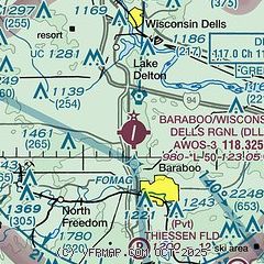
| Sectional chart |
|---|
|
| Airport distance calculator |
|---|
|
|
| Sunrise and sunset |
|---|
|
Times for 27-Apr-2025
| | Local
(UTC-5) | | Zulu
(UTC) |
|---|
| Morning civil twilight | | 05:28 | | 10:28 |
| Sunrise | | 05:58 | | 10:58 |
| Sunset | | 19:55 | | 00:55 |
| Evening civil twilight | | 20:26 | | 01:26 |
|
| Current date and time |
|---|
| Zulu (UTC) | 27-Apr-2025 12:57:32 |
|---|
| Local (UTC-5) | 27-Apr-2025 07:57:32 |
|---|
|
| METAR |
|---|
| KDLL | 271255Z AUTO 12005KT 10SM BKN110 08/03 A3030 RMK AO2 T00750025
|
KC35
9nm W | 271235Z AUTO 00000KT 10SM OVC110 08/02 A3029 RMK AO2 T00800019 PWINO
|
|
| TAF |
|---|
KMSN
30nm SE | 271120Z 2712/2812 09004KT P6SM SCT110 BKN180 FM271400 14007KT P6SM BKN110 FM271800 17011KT P6SM SCT200 FM280100 15006KT P6SM FEW150 FM280900 17011KT P6SM BKN100 PROB30 2810/2812 -TSRA BKN080CB
|
KVOK
32nm NW | 270900Z 2709/2815 16009KT 9999 SCT120 QNH3023INS BECMG 2716/2717 16012G18KT 9999 BKN100 QNH3009INS BECMG 2723/2724 15010G15KT 9999 BKN050 QNH3001INS BECMG 2809/2810 15015G25KT 8000 -TSRA BKN030CB QNH2998INS TX17/2721Z TN05/2709Z
|
|
| NOTAMs |
|---|
NOTAMs are issued by the DoD/FAA and will open in a separate window not controlled by AirNav.
|
|


