FAA INFORMATION EFFECTIVE 17 APRIL 2025
Location
| FAA Identifier: | ETB |
| Lat/Long: | 43-25-19.8250N 088-07-40.5350W
43-25.330417N 088-07.675583W
43.4221736,-88.1279264
(estimated) |
| Elevation: | 887.9 ft. / 270.6 m (surveyed) |
| Variation: | 01W (1985) |
| From city: | 3 miles E of WEST BEND, WI |
| Time zone: | UTC -5 (UTC -6 during Standard Time) |
| Zip code: | 53095 |
Airport Operations
| Airport use: | Open to the public |
| Activation date: | 02/1938 |
| Control tower: | no |
| ARTCC: | CHICAGO CENTER |
| FSS: | GREEN BAY FLIGHT SERVICE STATION |
| NOTAMs facility: | ETB (NOTAM-D service available) |
| Attendance: | 0800-1800 |
| Wind indicator: | lighted |
| Segmented circle: | no |
| Lights: | ACTVT REIL RWY 13 & 31; PAPI RWY 13 & 31; MIRL RWY 06/24 - CTAF. MIRL RWY 13/31 PRESET TO LOW SS-SR, TO INCR INTST & ACTVT - CTAF. |
| Beacon: | white-green (lighted land airport)
Operates sunset to sunrise. |
Airport Communications
| CTAF/UNICOM: | 123.05 |
| WX AWOS-3: | 120.0 (262-334-6161) |
| MILWAUKEE APPROACH: | 125.35 |
| MILWAUKEE DEPARTURE: | 125.35 |
| CLEARANCE DELIVERY: | 124.75 |
| ARNG OPS: | 138.625 240.3 40.9 |
| GOPAC STAR: | 126.5 |
| NG OPS: | 241.0 40.8 41.6 |
| WX AWOS-3 at MWC (19 nm S): | PHONE 414-461-2954 |
Nearby radio navigation aids
| VOR radial/distance | | VOR name | | Freq | | Var |
|---|
| BJB at field | | WEST BEND VOR | | 109.80 | | 01W |
| BAEr018/19.6 | | BADGER VOR/DME | | 116.40 | | 02E |
| OSHr149/38.8 | | OSHKOSH VORTAC | | 116.75 | | 02E |
| NDB name | | Hdg/Dist | | Freq | | Var | | ID |
|---|
| ROCK RIVER | | 061/30.0 | | 371 | | 01W | | RYV | .-. -.-- ...- |
Airport Services
| Fuel available: | 100LL JET-A |
| Parking: | hangars and tiedowns |
| Airframe service: | MAJOR |
| Powerplant service: | MAJOR |
| Bottled oxygen: | NONE |
| Bulk oxygen: | NONE |
Runway Information
Runway 13/31
| Dimensions: | 4494 x 75 ft. / 1370 x 23 m |
| Surface: | asphalt, in good condition |
| Weight bearing capacity: | |
| Runway edge lights: | medium intensity |
| RUNWAY 13 | | RUNWAY 31 |
| Latitude: | 43-25.521827N | | 43-25.082557N |
| Longitude: | 088-08.081732W | | 088-07.265178W |
| Elevation: | 882.2 ft. | | 867.9 ft. |
| Traffic pattern: | left | | left |
| Runway heading: | 127 magnetic, 126 true | | 307 magnetic, 306 true |
| Markings: | nonprecision, in fair condition | | nonprecision, in fair condition |
| Visual slope indicator: | 4-light PAPI on left (3.00 degrees glide path) | | 2-light PAPI on left (3.00 degrees glide path) |
| Runway end identifier lights: | yes | | yes |
| Touchdown point: | yes, no lights | | yes, no lights |
| Instrument approach: | | | LOCALIZER |
| Obstructions: | 12 ft. road, marked and lighted, 370 ft. from runway, 270 ft. left of centerline, 14:1 slope to clear | | 67 ft. trees, 1356 ft. from runway, 400 ft. left of centerline, 17:1 slope to clear |
Runway 6/24
| Dimensions: | 3898 x 75 ft. / 1188 x 23 m |
| Surface: | asphalt, in excellent condition |
| Weight bearing capacity: | |
| Runway edge lights: | medium intensity |
| RUNWAY 6 | | RUNWAY 24 |
| Latitude: | 43-25.197410N | | 43-25.528483N |
| Longitude: | 088-08.055012W | | 088-07.301117W |
| Elevation: | 887.0 ft. | | 875.0 ft. |
| Traffic pattern: | left | | left |
| Runway heading: | 060 magnetic, 059 true | | 240 magnetic, 239 true |
| Markings: | nonprecision, in good condition | | nonprecision, in good condition |
| Runway end identifier lights: | no | | no |
| Touchdown point: | yes, no lights | | yes, no lights |
| Obstructions: | 50 ft. trees, 1044 ft. from runway, 300 ft. left of centerline, 16:1 slope to clear | | 11 ft. road, 200 ft. from runway, 250 ft. right of centerline, 1:1 slope to clear |
Helipad H1
| Dimensions: | 100 x 100 ft. / 30 x 30 m |
| Surface: | asphalt, in good condition |
| Runway edge lights: | PERI
BLUE LGTS. |
| Operational restrictions: | MIL USE ONLY. |
| Latitude: | 43-25.313667N | | |
| Longitude: | 088-08.000000W | | |
| Elevation: | 882.0 ft. | | |
| Traffic pattern: | left | | left |
| Markings: | basic, in fair condition | | |
Airport Ownership and Management from official FAA records
| Ownership: | Publicly-owned |
| Owner: | CITY OF WEST BEND
1115 S MAIN STREET
WEST BEND, WI 53095
Phone 262-483-7432 |
| Manager: | MIKE SHAW
1115 SOUTH MAIN
WEST BEND, WI 53095
Phone 262-483-7432
EMAIL ADDRESS: SHAWM@CI.WEST-BEND.WI.US (ALL LOWER CASE) |
Additional Remarks
| - | WHEN USING MIL HELIPAD MIL HELS USE PATTERNS TO THE NORTH OR WEST OF ARPT. |
| - | WILDLIFE ON & INVOF ARPT. |
| - | COPTER TRNG IN PROGRESS 0630-2200 BLO 5000 FT. |
| - | FUEL - J8 (NC-100LL, A). |
| - | ARNG - OPR 1230-2200Z++ MON-TUE; 1230-0400Z++ WED-FRI. LTD PRK. PPR TRAN SVC DSN 724-7550, C262-334-6712. |
| - | CAUTION - COPTER TRNG IN PROGRESS 1230-0400Z++ BLW 5000'. MIL COPTER USE PAT TO N OR W OF ARPT. DEER HAZ. |
| - | ARNG - OPR 1230-2200Z++ MON-TUE; 1230-0400Z++ WED-FRI. LTD PRK. PPR TRAN SVC DSN 724-3417, C262-334-9154. |
| - | CTC ARNG OPS 40.8/40.9/41.6/138.625/240.3/241.0. |
| - | FOR CD CTC CHICAGO ARTCC AT 630-906-8921. |
Instrument Procedures
NOTE: All procedures below are presented as PDF files. If you need a reader for these files, you should download the free Adobe Reader.NOT FOR NAVIGATION. Please procure official charts for flight.
FAA instrument procedures published for use from 17 April 2025 at 0901Z to 15 May 2025 at 0900z.
STARs - Standard Terminal Arrivals |
|---|
| GOPAC THREE (RNAV) | |
download (233KB) |
IAPs - Instrument Approach Procedures |
|---|
| RNAV (GPS) RWY 06 | |
download (233KB) |
| RNAV (GPS) RWY 13 | |
download (231KB) |
| RNAV (GPS) RWY 24 | |
download (237KB) |
| RNAV (GPS) RWY 31 | |
download (261KB) |
| VOR RWY 13 | |
download (204KB) |
| VOR RWY 24 | |
download (196KB) |
| NOTE: Special Alternate Minimums apply | |
download (140KB) |
Departure Procedures |
|---|
| ACCRA FIVE (RNAV) | |
download (184KB) |
| UECKR SIX (RNAV) | |
download (200KB) |
| NOTE: Special Take-Off Minimums/Departure Procedures apply | |
download (201KB) |
Other nearby airports with instrument procedures:
KHXF - Hartford Municipal Airport (12 nm W)
KMWC - Lawrence J Timmerman Airport (19 nm S)
KUES - Waukesha County Airport (23 nm S)
KSBM - Sheboygan County Memorial International Airport (24 nm NE)
KUNU - Dodge County Airport (25 nm W)
|
|

Road maps at:
MapQuest
Bing
Google
| Aerial photo |
|---|
WARNING: Photo may not be current or correct
 Photo by Jeff Koon
Photo taken 22-Aug-2010
looking North.
Photo by Jeff Koon
Photo taken 22-Aug-2010
looking North.
Do you have a better or more recent aerial photo of West Bend Municipal Airport that you would like to share? If so, please send us your photo.
|
| Sectional chart |
|---|
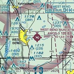
|
CAUTION: Diagram may not be current

| Airport distance calculator |
|---|
|
|
| Sunrise and sunset |
|---|
|
Times for 30-Apr-2025
| | Local
(UTC-5) | | Zulu
(UTC) |
|---|
| Morning civil twilight | | 05:17 | | 10:17 |
| Sunrise | | 05:48 | | 10:48 |
| Sunset | | 19:52 | | 00:52 |
| Evening civil twilight | | 20:23 | | 01:23 |
|
| Current date and time |
|---|
| Zulu (UTC) | 30-Apr-2025 18:30:32 |
|---|
| Local (UTC-5) | 30-Apr-2025 13:30:32 |
|---|
|
| METAR |
|---|
| KETB | 301815Z AUTO 10008KT 10SM CLR 14/06 A3012 RMK AO2
|
KMWC
19nm S | 301745Z 10010KT 10SM CLR 09/03 A3016
|
|
| TAF |
|---|
KUES
24nm S | 301736Z 3018/0118 12010G15KT P6SM BKN250 PROB30 0104/0106 6SM -SHRA OVC035 FM010600 09006KT 6SM -SHRA OVC050 FM011100 08008KT 4SM -SHRA OVC012 FM011300 07008KT 2SM -SHRA OVC006
|
KSBM
25nm NE | 301736Z 3018/0118 10008KT P6SM SCT250 PROB30 0105/0107 6SM -SHRA OVC035 FM010700 09005KT 6SM -SHRA OVC070 FM011000 09007KT 6SM -SHRA OVC040 FM011200 08008KT 4SM -SHRA OVC008
|
KMKE
30nm S | 301736Z 3018/0124 09007KT P6SM BKN250 PROB30 0104/0105 6SM -SHRA OVC035 FM010500 09005KT 6SM -SHRA OVC060 FM011200 07009KT 2SM -SHRA OVC006 FM011500 04008KT 1SM -SHRA OVC005 FM011700 02007KT 3SM -SHRA OVC006
|
|
| NOTAMs |
|---|
NOTAMs are issued by the DoD/FAA and will open in a separate window not controlled by AirNav.
|
|


