FAA INFORMATION EFFECTIVE 20 FEBRUARY 2025
Location
| FAA Identifier: | EVV |
| Lat/Long: | 38-02-26.9000N 087-31-42.6000W
38-02.448333N 087-31.710000W
38.0408056,-87.5285000
(estimated) |
| Elevation: | 421.9 ft. / 128.6 m (surveyed) |
| Variation: | 03W (2015) |
| From city: | 3 miles N of EVANSVILLE, IN |
| Time zone: | UTC -6 (UTC -5 during Daylight Saving Time) |
| Zip code: | 47725 |
Airport Operations
| Airport use: | Open to the public |
| Activation date: | 04/1940 |
| Control tower: | yes |
| ARTCC: | INDIANAPOLIS CENTER |
| FSS: | TERRE HAUTE FLIGHT SERVICE STATION |
| NOTAMs facility: | EVV (NOTAM-D service available) |
| Attendance: | CONTINUOUS |
| Wind indicator: | lighted |
| Segmented circle: | no |
| Lights: | ACTVT MALSR RWY 22; REIL RWY 4, 18 & 36; PAPI RWY 4; MIRL RWY 9/27; HIRL RWY 18/36 - CTAF. WHEN ATCT CLSD HIRL RWY 4/22 PRESET LOW INTS; INCR INTS - CTAF. |
| Beacon: | white-green (lighted land airport)
Operates sunset to sunrise. |
| Fire and rescue: | ARFF index B |
| Airline operations: | INDEX C ARFF AVBL O/R - 812-421-4408. |
Airport Communications
| CTAF: | 118.7 |
| UNICOM: | 122.95 |
| ATIS: | 120.2 |
| WX ASOS: | 120.2 (812-436-4681) |
| EVANSVILLE GROUND: | 121.9 [0600-2300] |
| EVANSVILLE TOWER: | 118.7 257.8 [0600-2300] |
| EVANSVILLE APPROACH: | 124.025 ;041-219 127.35 ;220-040 290.9 ;041-219 343.7 ;220-040 [0600-2300] |
| EVANSVILLE DEPARTURE: | 124.025 ;041-219 127.35 ;220-040 290.9 ;041-219 343.7 ;220-040 [0600-2300] |
| CLEARANCE DELIVERY: | 126.6 |
| CLASS C: | 124.025 ;041-219 127.35 ;220-040 290.9 ;041-219 343.7 ;220-040 |
| EMERG: | 121.5 243.0 |
| IC: | 124.025 ;041-219 290.9 ;041-219 |
| WX AWOS-3PT at EHR (16 nm SW): | 118.85 (270-826-0511) |
- APCH/DEP SVC PRVDD BY INDIANAPOLIS ARTCC ON FREQS 128.3/291.625 (EVANSVILLE RCAG) WHEN EVANSVILLE APCH CTL CLSD.
Nearby radio navigation aids
| VOR radial/distance | | VOR name | | Freq | | Var |
|---|
| PXVr056/13.0 | | POCKET CITY VORTAC | | 113.30 | | 03E |
| OWBr320/24.8 | | OWENSBORO VOR/DME | | 108.65 | | 04W |
Airport Services
| Fuel available: | 100LL JET-A |
| Parking: | hangars and tiedowns |
| Airframe service: | MAJOR |
| Powerplant service: | MAJOR |
| Bottled oxygen: | HIGH |
Runway Information
Runway 4/22
| Dimensions: | 8021 x 150 ft. / 2445 x 46 m |
| Surface: | asphalt/grooved, in good condition |
| Weight bearing capacity: | | Single wheel: | 100.0 | | Double wheel: | 175.0 | | Double tandem: | 300.0 |
|
| Runway edge lights: | high intensity |
| RUNWAY 4 | | RUNWAY 22 |
| Latitude: | 38-02.156862N | | 38-03.196855N |
| Longitude: | 087-31.840262W | | 087-30.809197W |
| Elevation: | 382.8 ft. | | 421.9 ft. |
| Traffic pattern: | left | | left |
| Runway heading: | 041 magnetic, 038 true | | 221 magnetic, 218 true |
| Declared distances: | TORA:8021 TODA:8021 ASDA:8021 LDA:8021 | | TORA:8021 TODA:8021 ASDA:8021 LDA:8021 |
| Markings: | precision, in good condition | | precision, in good condition |
| Visual slope indicator: | 4-light PAPI on right (3.00 degrees glide path) | | |
| RVR equipment: | rollout | | touchdown |
| Approach lights: | | | MALSR: 1,400 foot medium intensity approach lighting system with runway alignment indicator lights |
| Runway end identifier lights: | yes | | no |
| Touchdown point: | yes, no lights | | yes, no lights |
| Instrument approach: | ILS/DME | | ILS/DME |
| Obstructions: | 119 ft. tree, 5713 ft. from runway, 12 ft. left of centerline, 47:1 slope to clear | | 43 ft. pole, 2843 ft. from runway, 808 ft. right of centerline |
Runway 18/36
| Dimensions: | 6286 x 150 ft. / 1916 x 46 m |
| Surface: | asphalt/grooved, in good condition |
| Weight bearing capacity: | | Single wheel: | 100.0 | | Double wheel: | 175.0 | | Double tandem: | 300.0 |
|
| Runway edge lights: | high intensity |
| RUNWAY 18 | | RUNWAY 36 |
| Latitude: | 38-02.760855N | | 38-01.725297N |
| Longitude: | 087-32.044765W | | 087-32.071045W |
| Elevation: | 395.6 ft. | | 382.8 ft. |
| Traffic pattern: | left | | left |
| Runway heading: | 184 magnetic, 181 true | | 004 magnetic, 001 true |
| Displaced threshold: | no | | 789 ft. |
| Declared distances: | TORA:5497 TODA:5497 ASDA:5497 LDA:5497 | | TORA:6286 TODA:6286 ASDA:6286 LDA:5497 |
| Markings: | precision, in good condition | | precision, in good condition |
| Visual slope indicator: | 4-light PAPI on right (3.00 degrees glide path) | | 4-light PAPI on left (3.00 degrees glide path) |
| Runway end identifier lights: | yes | | yes |
| Touchdown point: | yes, no lights | | yes, no lights |
| Obstructions: | 64 ft. pole, lighted, 1430 ft. from runway, 120 ft. right of centerline, 19:1 slope to clear | | 15 ft. road, 277 ft. from runway, 10 ft. right of centerline, 5:1 slope to clear
APCH RATIO 25:1 AT DTHR; 51 FT LGTD BLDG 1296 FT FM THR 308 FT L; APCH RATIO 50:1 AT DTHR OVR ROAD. |
Runway 9/27
| Dimensions: | 3497 x 75 ft. / 1066 x 23 m |
| Surface: | asphalt, in good condition |
| Weight bearing capacity: | | PCN 3 /F/B/Z/U | | Single wheel: | 30.0 | | Double wheel: | 40.0 | | Double tandem: | 60.0 |
|
| Runway edge lights: | medium intensity |
| RUNWAY 9 | | RUNWAY 27 |
| Latitude: | 38-02.298250N | | 38-02.286880N |
| Longitude: | 087-32.330062W | | 087-31.601665W |
| Elevation: | 381.5 ft. | | 383.5 ft. |
| Traffic pattern: | left | | left |
| Runway heading: | 094 magnetic, 091 true | | 274 magnetic, 271 true |
| Displaced threshold: | 529 ft. | | 218 ft. |
| Declared distances: | TORA:3497 TODA:3497 ASDA:3497 LDA:2968 | | TORA:3497 TODA:3497 ASDA:3497 LDA:3279 |
| Markings: | basic, in good condition | | basic, in good condition |
| Runway end identifier lights: | no | | no |
| Touchdown point: | yes, no lights | | yes, no lights |
| Obstructions: | 14 ft. road, 375 ft. from runway, 250 ft. right of centerline, 12:1 slope to clear
APCH RATIO 20:1 AT DTHR; 60 FT TREES 1400 FT FM THR 250 FT L. | | 17 ft. road, 268 ft. from runway, 4:1 slope to clear
APCH RATIO 26:1 AT DTHR; 18 FT ROAD 475 FT FM THR 13 FT L. |
Airport Ownership and Management from official FAA records
| Ownership: | Publicly-owned |
| Owner: | EVANSVLLE-VANDERBURG ARPT AUTH
7801 BUSSING DR
EVANSVILLE, IN 47725-6799
Phone 812-421-4401 |
| Manager: | NATE HAHN
7801 BUSSING DR
EVANSVILLE, IN 47725-6799
Phone 812-421-4401 |
Additional Remarks
| A39-18/36 | PCR VALUE: 1049/F/B/X/T |
| A39-04/22 | PCR VALUE: 660/F/B/X/T |
| - | BIRDS ON & INVOF ARPT. |
| - | TWY E LGTS OTS. |
| - | FOR CD WHEN ATCT CLSD CTC INDIANAPOLIS ARTCC AT 317-247-2411. |
| - | RWY 09/27 & TWY E RSTRD TO LESS THAN 50000 LB. |
Instrument Procedures
NOTE: All procedures below are presented as PDF files. If you need a reader for these files, you should download the free Adobe Reader.NOT FOR NAVIGATION. Please procure official charts for flight.
FAA instrument procedures published for use from 20 February 2025 at 0901Z to 20 March 2025 at 0900Z.
IAPs - Instrument Approach Procedures |
|---|
| ILS OR LOC RWY 04 | |
download (293KB) |
| ILS OR LOC RWY 22 | |
download (311KB) |
| RNAV (GPS) RWY 04 | |
download (241KB) |
| RNAV (GPS) RWY 18 | |
download (251KB) |
| RNAV (GPS) RWY 22 | |
download (240KB) |
| RNAV (GPS) RWY 36 | |
download (264KB) |
| VOR RWY 04 | |
download (217KB) |
| Radar Approach Procedures available | |
download (160KB) |
| NOTE: Special Alternate Minimums apply | |
download (168KB) |
| NOTE: Special Take-Off Minimums/Departure Procedures apply **CHANGED** | |
download (476KB) |
Other nearby airports with instrument procedures:
KEHR - Henderson City-County Airport (16 nm SW)
KOWB - Owensboro/Daviess County Regional Airport (25 nm SE)
KCUL - Carmi Municipal Airport (28 nm W)
KHNB - Huntingburg Airport (30 nm NE)
KY8 - Hancock County Airport/Ron Lewis Field (32 nm E)
|
|

Road maps at:
MapQuest
Bing
Google
| Aerial photo |
|---|
WARNING: Photo may not be current or correct
 Photo by Geoffrey Stevenson
Photo taken 01-Aug-2008
Photo by Geoffrey Stevenson
Photo taken 01-Aug-2008
Do you have a better or more recent aerial photo of Evansville Regional Airport that you would like to share? If so, please send us your photo.
|
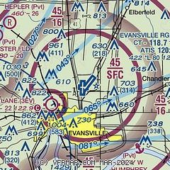
| Sectional chart |
|---|
|
 Download PDF
of official airport diagram from the FAA
| Airport distance calculator |
|---|
|
|
| Sunrise and sunset |
|---|
|
Times for 11-Mar-2025
| | Local
(UTC-6) | | Zulu
(UTC) |
|---|
| Morning civil twilight | | 05:42 | | 11:42 |
| Sunrise | | 06:08 | | 12:08 |
| Sunset | | 17:52 | | 23:52 |
| Evening civil twilight | | 18:18 | | 00:18 |
|
| Current date and time |
|---|
| Zulu (UTC) | 11-Mar-2025 18:28:18 |
|---|
| Local (UTC-6) | 11-Mar-2025 12:28:18 |
|---|
|
| METAR |
|---|
| KEVV | 111754Z 22009KT 10SM CLR 22/03 A2980 RMK AO2 SLP088 T02170028 10222 20061 58011 $
|
KEHR
15nm SW | 111756Z AUTO 22011KT 10SM CLR 22/04 A2980 RMK AO2 SLP091 T02170044 10217 20056 58011
|
|
| TAF |
|---|
| KEVV | 111720Z 1118/1218 21010G18KT P6SM SKC FM120000 20006KT P6SM SKC FM120900 20004KT P6SM SKC FM121500 22010KT P6SM FEW250
|
|
| NOTAMs |
|---|
NOTAMs are issued by the DoD/FAA and will open in a separate window not controlled by AirNav.
|
|


