FAA INFORMATION EFFECTIVE 17 APRIL 2025
Location
| FAA Identifier: | FEP |
| Lat/Long: | 42-14-46.0130N 089-34-55.1160W
42-14.766883N 089-34.918600W
42.2461147,-89.5819767
(estimated) |
| Elevation: | 859 ft. / 261.8 m (surveyed) |
| Variation: | 00E (1995) |
| From city: | 3 miles SE of FREEPORT, IL |
| Time zone: | UTC -5 (UTC -6 during Standard Time) |
| Zip code: | 61032 |
Airport Operations
| Airport use: | Open to the public |
| Activation date: | 10/1945 |
| Control tower: | no |
| ARTCC: | CHICAGO CENTER |
| FSS: | KANKAKEE FLIGHT SERVICE STATION |
| NOTAMs facility: | FEP (NOTAM-D service available) |
| Attendance: | MON-FRI 0800-1700, ALL SAT 0900-1600 |
| Pattern altitude: | 1259 ft. MSL
TPA: 400 FT AGL ULTRALIGHTS, 800 FT AGL PISTON ACFT. |
| Wind indicator: | lighted |
| Segmented circle: | yes |
| Lights: | MIRL RY 06/24 & TWY LGTS PRESET ON LOW INTST SS-SR; TO INCR INTST & ACTVT MALSR RY 24 - CTAF. PAPI RYS 06 & 24 OPERATE CONTINUOUSLY. |
| Beacon: | white-green (lighted land airport)
Operates sunset to sunrise. |
Airport Communications
| CTAF/UNICOM: | 122.8 |
| WX AWOS-3: | 120.525 (815-233-4472) |
| ROCKFORD APPROACH: | 126.0 |
| ROCKFORD DEPARTURE: | 126.0 |
| CLEARANCE DELIVERY: | 121.85 |
Nearby radio navigation aids
| VOR radial/distance | | VOR name | | Freq | | Var |
|---|
| JVLr225/28.2 | | JANESVILLE VOR/DME | | 114.30 | | 03E |
Airport Services
| Fuel available: | 100LL JET-A
100LL:100 LL AVAILABLE 24HR SELF SERVICE |
| Parking: | hangars and tiedowns |
| Airframe service: | MAJOR |
| Powerplant service: | MAJOR |
| Bottled oxygen: | NONE |
| Bulk oxygen: | NONE |
Runway Information
Runway 6/24
| Dimensions: | 5504 x 100 ft. / 1678 x 30 m |
| Surface: | asphalt/grooved, in good condition |
| Weight bearing capacity: | | Single wheel: | 20.0 | | Double wheel: | 60.0 |
|
| Runway edge lights: | medium intensity |
| RUNWAY 6 | | RUNWAY 24 |
| Latitude: | 42-14.396598N | | 42-14.926452N |
| Longitude: | 089-35.406348W | | 089-34.417115W |
| Elevation: | 859.0 ft. | | 840.6 ft. |
| Traffic pattern: | left | | left |
| Runway heading: | 054 | | 234 |
| Markings: | nonprecision, in good condition | | precision, in good condition |
| Visual slope indicator: | 4-light PAPI on left (3.00 degrees glide path) | | 4-light PAPI on left (3.00 degrees glide path) |
| Approach lights: | | | MALSR: 1,400 foot medium intensity approach lighting system with runway alignment indicator lights |
| Runway end identifier lights: | no | | no |
| Touchdown point: | yes, no lights | | yes, no lights |
| Instrument approach: | | | ILS/DME |
| Obstructions: | 52 ft. tree, 2118 ft. from runway, 243 ft. right of centerline, 34:1 slope to clear | | none |
Runway 18/36
| Dimensions: | 2404 x 150 ft. / 733 x 46 m |
| Surface: | turf, in good condition |
| Runway edge markings: | 18/36 THLDS MKD WITH IN-GROUND CONC MARKERS. |
| RUNWAY 18 | | RUNWAY 36 |
| Latitude: | 42-15.045333N | | 42-14.650010N |
| Longitude: | 089-34.984333W | | 089-34.976808W |
| Elevation: | 835.0 ft. | | 844.9 ft. |
| Traffic pattern: | left | | left |
| Runway heading: | 179 | | 359 |
| Markings: | none | | none |
| Runway end identifier lights: | no | | no |
| Touchdown point: | yes, no lights | | yes, no lights |
Runway 13/31
| Dimensions: | 2285 x 150 ft. / 696 x 46 m |
| Surface: | turf, in good condition |
| Runway edge markings: | 13/31 THLDS MKD WITH IN-GROUND CONC MARKERS. |
| RUNWAY 13 | | RUNWAY 31 |
| Latitude: | 42-15.046297N | | 42-14.825115N |
| Longitude: | 089-35.074648W | | 089-34.665210W |
| Elevation: | 834.7 ft. | | 841.1 ft. |
| Traffic pattern: | left | | left |
| Runway heading: | 126 | | 306 |
| Markings: | none | | none |
| Runway end identifier lights: | no | | no |
Airport Ownership and Management from official FAA records
| Ownership: | Publicly-owned |
| Owner: | CITY OF FREEPORT
CITY HALL , 314 W. STEPHENSON, 324 W. STEPHENSON
FREEPORT, IL 61032
Phone 815-235-8200 |
| Manager: | ANGIE JANNSEN
1255 E AIRPORT ROAD
FREEPORT, IL 61032
Phone 815-232-1078 |
Additional Remarks
| - | FOR CD CTC CHICAGO ARTCC AT 630-906-8921. |
Instrument Procedures
NOTE: All procedures below are presented as PDF files. If you need a reader for these files, you should download the free Adobe Reader.NOT FOR NAVIGATION. Please procure official charts for flight.
FAA instrument procedures published for use from 17 April 2025 at 0901Z to 15 May 2025 at 0900z.
IAPs - Instrument Approach Procedures |
|---|
| ILS OR LOC RWY 24 | |
download (270KB) |
| RNAV (GPS) RWY 06 | |
download (216KB) |
| RNAV (GPS) RWY 24 | |
download (267KB) |
| NOTE: Special Alternate Minimums apply | |
download (140KB) |
| NOTE: Special Take-Off Minimums/Departure Procedures apply | |
download (201KB) |
Other nearby airports with instrument procedures:
KRFD - Chicago/Rockford International Airport (22 nm E)
KEFT - Monroe Municipal Airport (22 nm N)
C73 - Dixon Municipal Airport-Charles R. Walgreen Field (25 nm S)
KSFY - Tri-Township Airport (26 nm SW)
KSQI - Whiteside County Airport/Jos H Bittorf Field (30 nm S)
|
|

Road maps at:
MapQuest
Bing
Google
| Aerial photo |
|---|
WARNING: Photo may not be current or correct
 Photo by Mathieu Labs
Photo taken 13-Jun-2018
looking south-southwest.
Photo by Mathieu Labs
Photo taken 13-Jun-2018
looking south-southwest.
Do you have a better or more recent aerial photo of Albertus Airport that you would like to share? If so, please send us your photo.
|
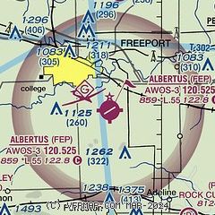
| Sectional chart |
|---|
|
| Airport distance calculator |
|---|
|
|
| Sunrise and sunset |
|---|
|
Times for 22-Apr-2025
| | Local
(UTC-5) | | Zulu
(UTC) |
|---|
| Morning civil twilight | | 05:38 | | 10:38 |
| Sunrise | | 06:08 | | 11:08 |
| Sunset | | 19:46 | | 00:46 |
| Evening civil twilight | | 20:16 | | 01:16 |
|
| Current date and time |
|---|
| Zulu (UTC) | 22-Apr-2025 23:42:03 |
|---|
| Local (UTC-5) | 22-Apr-2025 18:42:03 |
|---|
|
| TAF |
|---|
KRFD
22nm E | 222048Z 2221/2318 20013G21KT P6SM BKN080 TEMPO 2222/2302 5SM -TSRA BKN035CB FM230200 23008KT P6SM BKN060 FM230600 19006KT P6SM VCSH BKN070 FM231100 17006KT P6SM VCSH SCT025 BKN060 PROB30 2311/2315 4SM -TSRA BKN025CB
|
|
| NOTAMs |
|---|
NOTAMs are issued by the DoD/FAA and will open in a separate window not controlled by AirNav.
|
|


