FAA INFORMATION EFFECTIVE 20 FEBRUARY 2025
Location
| FAA Identifier: | FMZ |
| Lat/Long: | 40-35-09.9513N 097-34-23.2916W
40-35.165855N 097-34.388193W
40.5860976,-97.5731366
(estimated) |
| Elevation: | 1636.4 ft. / 498.8 m (surveyed) |
| Variation: | 03E (2025) |
| From city: | 3 miles S of FAIRMONT, NE |
| Time zone: | UTC -6 (UTC -5 during Daylight Saving Time) |
| Zip code: | 68354 |
Airport Operations
| Airport use: | Open to the public |
| Activation date: | 07/1944 |
| Control tower: | no |
| ARTCC: | MINNEAPOLIS CENTER |
| FSS: | COLUMBUS FLIGHT SERVICE STATION |
| NOTAMs facility: | OLU (NOTAM-D service available) |
| Attendance: | MON-FRI 0800-1700
AMGR RESIDENCE ON ARPT. |
| Wind indicator: | lighted |
| Segmented circle: | yes |
| Lights: | ACTVT MIRL RWY 17/35 - CTAF. |
| Beacon: | white-green (lighted land airport)
Operates sunset to sunrise. |
Airport Communications
| CTAF: | 122.9 |
| WX AWOS-3 at JYR (19 nm N): | 124.175 (402-362-3785) |
- APCH/DEP SVC PRVDD BY MINNEAPOLIS ARTCC ON FREQS 119.4/278.8 (HASTINGS RCAG).
Nearby radio navigation aids
| NDB name | | Hdg/Dist | | Freq | | Var | | ID |
|---|
| BEKLOF | | at field | | 392 | | 03E | | FMZ | ..-. -- --.. |
| YORK | | 168/18.8 | | 257 | | 06E | | JYR | .--- -.-- .-. |
| FAIRBURY | | 317/30.8 | | 293 | | 06E | | FBY | ..-. -... -.-- |
Airport Services
| Fuel available: | 100LL
100LL:CTC AMGR FOR FUEL; CASH OR CK ONLY. |
| Parking: | tiedowns |
| Airframe service: | NONE |
| Powerplant service: | NONE |
| Bottled oxygen: | NONE |
| Bulk oxygen: | NONE |
Runway Information
Runway 17/35
| Dimensions: | 4317 x 75 ft. / 1316 x 23 m |
| Surface: | concrete, in good condition |
| Runway edge lights: | medium intensity |
| RUNWAY 17 | | RUNWAY 35 |
| Latitude: | 40-35.671498N | | 40-34.960525N |
| Longitude: | 097-34.267673W | | 097-34.264780W |
| Elevation: | 1635.3 ft. | | 1634.0 ft. |
| Traffic pattern: | left | | left |
| Runway heading: | 177 magnetic, 180 true | | 357 magnetic, 360 true |
| Markings: | nonprecision, in good condition | | nonprecision, in good condition |
| Touchdown point: | yes, no lights | | yes, no lights |
Runway 12/30
| Dimensions: | 3021 x 60 ft. / 921 x 18 m |
| Surface: | concrete, in poor condition
SGFNT CRACKS, SPALLS, & ALKALI-SILICA REACTIVITY. |
| RUNWAY 12 | | RUNWAY 30 |
| Latitude: | 40-35.126662N | | 40-34.775977N |
| Longitude: | 097-34.793887W | | 097-34.331033W |
| Elevation: | 1635.8 ft. | | 1632.7 ft. |
| Traffic pattern: | left | | left |
| Runway heading: | 132 magnetic, 135 true | | 312 magnetic, 315 true |
| Markings: | basic, in good condition | | basic, in good condition |
| Touchdown point: | yes, no lights | | yes, no lights |
Airport Ownership and Management from official FAA records
| Ownership: | Publicly-owned |
| Owner: | NEBR. DOT, DIVISION OF AERONAUTICS
1600 NEBRASKA PARKWAY
LINCOLN, NE 68502-4101
Phone 402-471-2371 |
| Manager: | TIM KRIENERT
13 AIRBASE ROAD, FAIRMONT STATE AIRFIELD
FAIRMONT, NE 68354-4057
Phone 402-266-1890 |
Additional Remarks
| - | FOR CD CTC MINNEAPOLIS ARTCC AT 651-463-5588. |
Instrument Procedures
NOTE: All procedures below are presented as PDF files. If you need a reader for these files, you should download the free Adobe Reader.NOT FOR NAVIGATION. Please procure official charts for flight.
FAA instrument procedures published for use from 20 February 2025 at 0901Z to 20 March 2025 at 0900Z.
IAPs - Instrument Approach Procedures |
|---|
| RNAV (GPS) RWY 17 | |
download (201KB) |
| RNAV (GPS) RWY 35 | |
download (206KB) |
| NDB RWY 17 | |
download (162KB) |
| NDB RWY 35 | |
download (170KB) |
| NOTE: Special Take-Off Minimums/Departure Procedures apply | |
download (356KB) |
Other nearby airports with instrument procedures:
KJYR - York Municipal Airport (19 nm N)
08K - Harvard State Airport (23 nm W)
KHJH - Hebron Municipal Airport (26 nm S)
KAUH - Aurora Municipal Airport/Al Potter Field (27 nm NW)
KSWT - Seward Municipal Airport (27 nm NE)
|
|

Road maps at:
MapQuest
Bing
Google
| Aerial photo |
|---|
WARNING: Photo may not be current or correct

Do you have a better or more recent aerial photo of Fairmont State Airport that you would like to share? If so, please send us your photo.
|
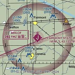
| Sectional chart |
|---|
|
| Airport distance calculator |
|---|
|
|
| Sunrise and sunset |
|---|
|
Times for 11-Mar-2025
| | Local
(UTC-6) | | Zulu
(UTC) |
|---|
| Morning civil twilight | | 06:22 | | 12:22 |
| Sunrise | | 06:49 | | 12:49 |
| Sunset | | 18:31 | | 00:31 |
| Evening civil twilight | | 18:59 | | 00:59 |
|
| Current date and time |
|---|
| Zulu (UTC) | 11-Mar-2025 18:15:34 |
|---|
| Local (UTC-6) | 11-Mar-2025 12:15:34 |
|---|
|
| METAR |
|---|
KJYR
19nm N | 111755Z AUTO 02011KT 10SM CLR 08/M02 A2985 RMK AO2
|
KHJH
26nm S | 111755Z AUTO 03007KT 10SM 12/00 A2982 RMK AO2 T01201004 10121 20037
|
KAUH
26nm NW | 111755Z AUTO 02008KT 10SM CLR 07/M02 A2986 RMK AO2 T00681020 10071 20010
|
|
| TAF |
|---|
KLNK
40nm E | 111722Z 1118/1218 03010KT P6SM FEW250 FM120800 15005KT P6SM SCT250
|
KGRI
41nm NW | 111720Z 1118/1218 04010G15KT P6SM FEW250 FM112000 09007KT P6SM SKC FM120000 VRB06KT P6SM FEW250 FM120600 16006KT P6SM SCT250 FM121200 24005KT P6SM SCT240 FM121500 21007KT P6SM FEW250
|
|
| NOTAMs |
|---|
NOTAMs are issued by the DoD/FAA and will open in a separate window not controlled by AirNav.
|
|


