FAA INFORMATION EFFECTIVE 20 FEBRUARY 2025
Location
| FAA Identifier: | FSE |
| Lat/Long: | 47-35-34.1870N 095-46-24.5520W
47-35.569783N 095-46.409200W
47.5928297,-95.7734867
(estimated) |
| Elevation: | 1278.7 ft. / 389.7 m (surveyed) |
| Variation: | 03E (2010) |
| From city: | 1 mile NW of FOSSTON, MN |
| Time zone: | UTC -6 (UTC -5 during Daylight Saving Time) |
| Zip code: | 56542 |
Airport Operations
| Airport use: | Open to the public |
| Activation date: | 09/1948 |
| Control tower: | no |
| ARTCC: | MINNEAPOLIS CENTER |
| FSS: | PRINCETON FLIGHT SERVICE STATION |
| NOTAMs facility: | FSE (NOTAM-D service available) |
| Attendance: | UNATNDD |
| Wind indicator: | lighted |
| Segmented circle: | no |
| Lights: | ACTVT OR INCR INTST REIL RWY 16 & 34; PAPI RWY 16 & 34; NSTD MIRL RWY 16/34 - CTAF. NSTD MIRL RWY 16/34 PRESET LOW INTST. |
| Beacon: | white-green (lighted land airport)
Operates sunset to sunrise. |
Airport Communications
| CTAF: | 122.9 |
| WX AWOS-3: | 118.35 (218-435-6448) |
- APCH/DEP SVC PRVDD BY MINNEAPOLIS ARTCC ON FREQS 134.75/251.1 (BEMIDJI RCAG).
Nearby radio navigation aids
| VOR radial/distance | | VOR name | | Freq | | Var |
|---|
| TVFr142/33.1 | | THIEF RIVER FALLS VOR/DME | | 114.45 | | 08E |
| IDJr277/34.8 | | LAKE BEMIDJI VOR/DME | | 110.00 | | 01E |
Airport Services
| Fuel available: | 100LL
100LL:FUEL AVBL H24 SELF SVC VIA CREDIT CARD. |
| Parking: | tiedowns |
| Airframe service: | NONE |
| Powerplant service: | NONE |
| Bottled oxygen: | NONE |
| Bulk oxygen: | NONE |
Runway Information
Runway 16/34
| Dimensions: | 3502 x 75 ft. / 1067 x 23 m |
| Surface: | asphalt, in good condition |
| Weight bearing capacity: | |
| Runway edge lights: | non-standard
NSTD MIRL DUE TO RWY 34 LGTS NOT YELLOW LAST HALF RWY LEN. |
| RUNWAY 16 | | RUNWAY 34 |
| Latitude: | 47-35.850840N | | 47-35.288735N |
| Longitude: | 095-46.501922W | | 095-46.316508W |
| Elevation: | 1266.3 ft. | | 1278.7 ft. |
| Traffic pattern: | left | | left |
| Runway heading: | 164 magnetic, 167 true | | 344 magnetic, 347 true |
| Markings: | nonprecision, in fair condition | | nonprecision, in fair condition |
| Visual slope indicator: | 4-light PAPI on left (2.80 degrees glide path) | | 4-light PAPI on left (2.80 degrees glide path) |
| Runway end identifier lights: | yes | | yes |
| Touchdown point: | yes, no lights | | yes, no lights |
| Obstructions: | 46 ft. trees, 423 ft. from runway, 269 ft. left of centerline, 4:1 slope to clear
3 FT CROPS, 43 FT DIST, 158 FT R. | | 19 ft. road, 800 ft. from runway, 315 ft. left of centerline, 31:1 slope to clear |
Airport Ownership and Management from official FAA records
| Ownership: | Publicly-owned |
| Owner: | CITY OF FOSSTON
CITY HALL, 220 1ST ST E
FOSSTON, MN 56542-1337
Phone 218-435-1959 |
| Manager: | CASSIE HEIDE
220 1ST ST E
FOSSTON, MN 56542-1337
Phone 218-435-1959 |
Additional Remarks
| - | GCO AVBL ON FREQ 121.725 THRU MINNEAPOLIS ARTCC & FLT SVCS. |
| - | FOR CD IF UNA VIA GCO CTC MINNEAPOLIS ARTCC AT 651-463-5588. |
Instrument Procedures
NOTE: All procedures below are presented as PDF files. If you need a reader for these files, you should download the free Adobe Reader.NOT FOR NAVIGATION. Please procure official charts for flight.
FAA instrument procedures published for use from 20 February 2025 at 0901Z to 20 March 2025 at 0900Z.
IAPs - Instrument Approach Procedures |
|---|
| RNAV (GPS) RWY 16 | |
download (224KB) |
| RNAV (GPS) RWY 34 | |
download (227KB) |
| NOTE: Special Alternate Minimums apply | |
download (175KB) |
| NOTE: Special Take-Off Minimums/Departure Procedures apply | |
download (406KB) |
Other nearby airports with instrument procedures:
3N8 - Mahnomen County Airport (21 nm S)
D14 - Fertile Municipal Airport (21 nm W)
D00 - Norman County Ada/Twin Valley Airport (32 nm SW)
KTVF - Thief River Falls Regional Airport (33 nm NW)
KBJI - Bemidji Regional Airport (34 nm E)
|
|

Road maps at:
MapQuest
Bing
Google
| Aerial photo |
|---|
WARNING: Photo may not be current or correct
 Photo by Mark Robinson
www.wemakepilots.com
Photo taken 23-Jun-2020
looking south.
Do you have a better or more recent aerial photo of Fosston Municipal Airport/Anderson Field that you would like to share? If so, please send us your photo.
|
| Sectional chart |
|---|
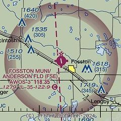
|
| Airport distance calculator |
|---|
|
|
| Sunrise and sunset |
|---|
|
Times for 10-Mar-2025
| | Local
(UTC-6) | | Zulu
(UTC) |
|---|
| Morning civil twilight | | 06:16 | | 12:16 |
| Sunrise | | 06:47 | | 12:47 |
| Sunset | | 18:20 | | 00:20 |
| Evening civil twilight | | 18:50 | | 00:50 |
|
| Current date and time |
|---|
| Zulu (UTC) | 10-Mar-2025 09:17:41 |
|---|
| Local (UTC-6) | 10-Mar-2025 03:17:41 |
|---|
|
| METAR |
|---|
| KFSE | 100855Z AUTO 21008KT 10SM CLR 01/M02 A2959 RMK AO2
|
|
| TAF |
|---|
KTVF
33nm NW | 100520Z 1006/1106 VRB05KT P6SM SCT200 FM101200 20010KT P6SM SCT200 FM101500 24013KT P6SM SCT200 FM101800 27016G26KT P6SM SCT200 FM102200 34025G40KT P6SM -SHRASN BKN040 FM110300 35023G38KT P6SM -SHSN BKN030
|
KBJI
35nm E | 100520Z 1006/1106 VRB03KT P6SM SCT200 FM101500 24010KT P6SM SCT200 FM101800 26014G23KT P6SM SCT200 FM102100 28017G25KT P6SM BKN200 FM110000 33017G27KT 5SM -SHRASN BKN040 FM110300 33017G27KT 5SM -SHSN OVC020
|
|
| NOTAMs |
|---|
NOTAMs are issued by the DoD/FAA and will open in a separate window not controlled by AirNav.
|
|


