FAA INFORMATION EFFECTIVE 23 JANUARY 2025
Location
| FAA Identifier: | GCD |
| Lat/Long: | 44-24-10.7352N 118-58-03.7901W
44-24.178920N 118-58.063168W
44.4029820,-118.9677195
(estimated) |
| Elevation: | 3702.5 ft. / 1128.5 m (surveyed) |
| Variation: | 17E (1995) |
| From city: | 1 mile SW of JOHN DAY, OR |
| Time zone: | UTC -8 (UTC -7 during Daylight Saving Time) |
| Zip code: | 97845 |
Airport Operations
| Airport use: | Open to the public |
| Activation date: | 12/1943 |
| Control tower: | no |
| ARTCC: | SEATTLE CENTER |
| FSS: | MC MINNVILLE FLIGHT SERVICE STATION |
| NOTAMs facility: | GCD (NOTAM-D service available) |
| Attendance: | OCT-MAY MON-SAT 0800-1600, JUN-SEP 0700-1900 |
| Wind indicator: | lighted |
| Segmented circle: | yes |
| Lights: | ACTVT REIL RWY 09 & 17; PAPI RWY 09; MIRL RWY 09/27 & 17/35 - CTAF. PAPI RWY 17 ON CONSLY. |
| Beacon: | white-green (lighted land airport)
Operates sunset to sunrise. |
Airport Communications
| CTAF/UNICOM: | 122.8 |
| WX AWOS-3: | 118.375 (541-575-1122) |
- APCH/DEP CTL SVC PRVDD BY SEATTLE ARTCC (ZSE) ON FREQS 128.15/257.75 (REDMOND RCAG).
Nearby radio navigation aids
| VOR radial/distance | | VOR name | | Freq | | Var |
|---|
| IMBr095/35.1 | | KIMBERLY VOR/DME | | 115.60 | | 20E |
Airport Services
| Fuel available: | 100LL JET-A |
| Parking: | tiedowns |
Runway Information
Runway 17/35
| Dimensions: | 5224 x 60 ft. / 1592 x 18 m |
| Surface: | asphalt, in good condition |
| Weight bearing capacity: | |
| Runway edge lights: | medium intensity |
| Runway edge markings: | PLUS AIMING POINT. |
| RUNWAY 17 | | RUNWAY 35 |
| Latitude: | 44-24.653150N | | 44-23.795765N |
| Longitude: | 118-57.778340W | | 118-57.862752W |
| Elevation: | 3675.0 ft. | | 3702.5 ft. |
| Traffic pattern: | left | | left |
| Runway heading: | 167 magnetic, 184 true | | 347 magnetic, 004 true |
| Markings: | basic, in fair condition | | basic, in fair condition |
| Visual slope indicator: | 4-light PAPI on left (4.00 degrees glide path) | | |
| Runway end identifier lights: | yes | | |
| Touchdown point: | yes, no lights | | yes, no lights |
Runway 9/27
| Dimensions: | 4100 x 60 ft. / 1250 x 18 m |
| Surface: | asphalt, in good condition |
| Weight bearing capacity: | |
| Runway edge lights: | medium intensity |
| RUNWAY 9 | | RUNWAY 27 |
| Latitude: | 44-24.235875N | | 44-24.005925N |
| Longitude: | 118-58.814758W | | 118-57.929852W |
| Elevation: | 3646.8 ft. | | 3688.9 ft. |
| Traffic pattern: | left | | right |
| Runway heading: | 093 magnetic, 110 true | | 273 magnetic, 290 true |
| Markings: | nonprecision, in good condition | | basic, in good condition |
| Visual slope indicator: | 4-light PAPI on left (3.00 degrees glide path) | | |
| Runway end identifier lights: | yes | | |
| Touchdown point: | yes, no lights | | yes, no lights |
| Obstructions: | 10 ft. fence, 333 ft. from runway, 13:1 slope to clear | | none |
Helipad H1
| Dimensions: | 30 x 30 ft. / 9 x 9 m |
| Surface: | concrete |
| Latitude: | 44-24.120667N | | |
| Longitude: | 118-57.728667W | | |
| Elevation: | 3690.0 ft. | | |
| Traffic pattern: | left | | left |
Helipad H2
| Dimensions: | 20 x 20 ft. / 6 x 6 m |
| Surface: | concrete |
| Latitude: | 44-24.099000N | | |
| Longitude: | 118-57.728667W | | |
| Elevation: | 3689.0 ft. | | |
| Traffic pattern: | left | | left |
Helipad H3
| Dimensions: | 20 x 20 ft. / 6 x 6 m |
| Surface: | concrete |
| Latitude: | 44-24.074667N | | |
| Longitude: | 118-57.729667W | | |
| Elevation: | 3631.4 ft. | | |
| Traffic pattern: | left | | left |
Airport Ownership and Management from official FAA records
| Ownership: | Publicly-owned |
| Owner: | GRANT COUNTY REGIONAL AIRPORT
, 201 S. HUMBOLT, STE. 280
CANYON CITY, OR 97820
Phone 541-575-1151 |
| Manager: | HALEY WALKER
72000 AIRPORT ROAD
JOHN DAY, OR 97845
Phone 541-575-1151 |
Additional Remarks
| A54-35 | +850FT TRRN 9400 FT S. |
| - | SOFT EDGES ALG RWYS & TWYS. TWYS MKD WITH REFLECTORS. |
| - | 8 FT FENCE ARND ARPT. |
| - | HEL ACT JUL-OCT. |
| - | FOR CD CTC SEATTLE ARTCC AT 253-351-3694. |
| - | AFT HR SELF SVC FUEL AVBL. |
Instrument Procedures
NOTE: All procedures below are presented as PDF files. If you need a reader for these files, you should download the free Adobe Reader.NOT FOR NAVIGATION. Please procure official charts for flight.
FAA instrument procedures published for use from 23 January 2025 at 0901Z to 20 February 2025 at 0900z.
IAPs - Instrument Approach Procedures |
|---|
| RNAV (GPS) Y RWY 09 | |
download (295KB) |
| RNAV (GPS) Z RWY 09 | |
download (297KB) |
| NOTE: Special Alternate Minimums apply | |
download (171KB) |
| NOTE: Special Take-Off Minimums/Departure Procedures apply | |
download (520KB) |
Other nearby airports with instrument procedures:
KBNO - Burns Municipal Airport (49 nm S)
KBKE - Baker City Municipal Airport (56 nm NE)
KLGD - La Grande/Union County Airport (67 nm NE)
9S9 - Lexington Airport (70 nm NW)
KPDT - Eastern Oregon Regional Airport at Pendleton (78 nm N)
|
|

Road maps at:
MapQuest
Bing
Google
| Aerial photo |
|---|
WARNING: Photo may not be current or correct
 Photo by Cheryl Berry, John Day, Oregon 97845
Photo taken 09-Sep-2009
Photo by Cheryl Berry, John Day, Oregon 97845
Photo taken 09-Sep-2009
Do you have a better or more recent aerial photo of Grant County Regional Airport/Ogilvie Field that you would like to share? If so, please send us your photo.
|
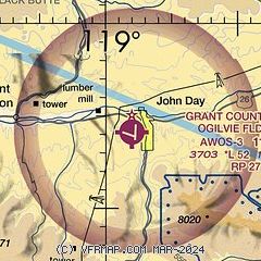
| Sectional chart |
|---|
|
| Airport distance calculator |
|---|
|
|
| Sunrise and sunset |
|---|
|
Times for 10-Feb-2025
| | Local
(UTC-8) | | Zulu
(UTC) |
|---|
| Morning civil twilight | | 06:34 | | 14:34 |
| Sunrise | | 07:04 | | 15:04 |
| Sunset | | 17:17 | | 01:17 |
| Evening civil twilight | | 17:47 | | 01:47 |
|
| Current date and time |
|---|
| Zulu (UTC) | 11-Feb-2025 05:13:28 |
|---|
| Local (UTC-8) | 10-Feb-2025 21:13:28 |
|---|
|
| METAR |
|---|
| KGCD | 110450Z AUTO 00000KT 7SM UP BKN020 BKN033 OVC046 M06/M08 A3013 RMK AO2 T10601079
|
|
| TAF |
|---|
KBNO
48nm S | 110338Z 1104/1124 VRB03KT P6SM SCT005 OVC040 PROB30 1104/1106 1/2SM -SN FZFG OVC004 FM110700 33004KT 1/2SM -SN FZFG OVC003 FM111200 VRB05KT 6SM BR FEW007 BKN030
|
|
| NOTAMs |
|---|
NOTAMs are issued by the DoD/FAA and will open in a separate window not controlled by AirNav.
|
|


