FAA INFORMATION EFFECTIVE 17 APRIL 2025
Location
| FAA Identifier: | HUA |
| Lat/Long: | 34-40-43.1790N 086-41-05.2460W
34-40.719650N 086-41.087433W
34.6786608,-86.6847906
(estimated) |
| Elevation: | 685.4 ft. / 209 m (estimated) |
| Variation: | 04W (2020) |
| From city: | 6 miles SW of REDSTONE ARSNL HUNTSVILLE, AL |
| Time zone: | UTC -5 (UTC -6 during Standard Time) |
| Zip code: | 35808 |
Airport Operations
| Airport use: | Private use. Permission required prior to landing |
| Control tower: | yes |
| ARTCC: | MEMPHIS CENTER |
| FSS: | ANNISTON FLIGHT SERVICE STATION |
| NOTAMs facility: | HUA (NOTAM-D service available) |
| Attendance: | MON-FRI 0700-1800, CLDS HOLS |
| Segmented circle: | no |
| Lights: | WHEN ATCT CLSD ACTVT MALSR RWY 17; PAPI RWY 17 & 35; HIRL RWY 17/35 - CTAF. |
| Beacon: | white-white-green (lighted military airport)
Operates sunset to sunrise. |
Airport Communications
| CTAF: | 126.95 |
| ATIS: | 120.65 |
| REDSTONE TOWER: | 126.95 290.275 [OPR 1330-2130Z++ MON-FRI EXC HOLS.] |
| HUNTSVILLE APPROACH: | 125.6 |
| HUNTSVILLE DEPARTURE: | 125.6 |
| EMERG: | 121.5 243.0 |
| GCA: | 124.8 229.4 |
| OPS: | 126.2 |
| WX ASOS at HSV (5 nm SW): | 121.25 (256-207-5925) |
| WX AWOS-3PT at MDQ (13 nm NE): | 120.000 (256-829-1242) |
| WX ASOS at DCU (13 nm W): | 118.375 (256-350-4270) |
- APCH/DEP SVC PRVDD BY MEMPHIS ARTCC ON FREQS 120.8/307.0 (HUNTSVILLE RCAG) WHEN HUNTSVILLE APCH CTL CLSD.
- USE 124.8 AS ADZY FREQ WHEN TOWER CLSD.
- GCA OPER 1330-2130Z++ MON-FRI EXCP HOLS, OTR TIMES ON REQ.
Nearby radio navigation aids
| VOR radial/distance | | VOR name | | Freq | | Var |
|---|
| RQZr197/7.5 | | ROCKET VORTAC | | 112.20 | | 02E |
Airport Services
Runway Information
Runway 17/35
| Dimensions: | 7300 x 150 ft. / 2225 x 46 m |
| Surface: | asphalt, in good condition |
| Weight bearing capacity: | |
| Runway edge lights: | high intensity |
| RUNWAY 17 | | RUNWAY 35 |
| Latitude: | 34-41.311267N | | 34-40.128017N |
| Longitude: | 086-41.220367W | | 086-40.954533W |
| Elevation: | 685.4 ft. | | 654.9 ft. |
| Traffic pattern: | left | | right
TFC PAT: RGT TFC RWY 35 R/W 1400 FT, F/W SENG 1700 FT, F/W TURBOPROP/JET 2200 FT, OVERHEAD 2700 FT. |
| Markings: | precision, in good condition | | precision, in good condition |
| Visual slope indicator: | 4-light PAPI on left (3.00 degrees glide path) | | 4-light PAPI on left (3.00 degrees glide path) |
| Approach lights: | MALSR: 1,400 foot medium intensity approach lighting system with runway alignment indicator lights | | |
| Touchdown point: | yes, no lights | | yes, no lights |
Airport Ownership and Management from official FAA records
| Ownership: | U.S. Army |
| Owner: | COMMANDER USAASA
9325 GUNSTON ROAD, BLDG 1466 SUITE N319
FORT BELVOIR, VA 22060 |
| Manager: | US ARMY
AMSAM-RA-EPW-BA BLDG 4488
HUNSTVILLE, AL 35898 |
Additional Remarks
| - | FUEL: A ++ (AVBL 1230-0330Z++ MON-FRI EXC HOL; OT O/R). |
| - | TRAN ALERT: LTD SVC. |
| - | RSTD: 24 HR PPR ALL ACFT, 48 HR PPR ACFT WITH HAZ CARGO. CTC BASE OPS DSN 746-7916/4299 C256-876-1916/4299. REFUL EXP DELAY. ACFT MUST ADHERE TO PPR ARR BLOCK TIME +/- 30 MIN OF SKED LDG. |
| - | MISC: LTD PRK. NO PHOTOGRAPHY ALLOWED WO BASE OPS APVL. |
| - | CAUTION: DEER, TUKEY, COYOTE HAZ. ACFT LARGER THAN C-12 USE EXTREME CAUTION WHILE TAXIING DUE TO MIN WG TIP CLNC. |
| - | RADAR: SEE TERMINAL FLIP FOR RADAR MINIMA. |
| - | PAR AND PAPI RWY 17-35 ARE COINCIDENTAL. |
| - | MISC: F/W LARGER THAN C130 RSTD TO TWY D, E, AND N RAMP AREA. LAWRS. ALL TRAN ACFT OPN OTHER THAN KHUA MUST RCV RNG BRIEFING FROM BASE OPS PRIOR TO OPN. |
| - | BASE OPS - OPR 1300-2200Z++ MON-FRI EXC HOL. OT O/R. 126.2 OR 239.275. |
| - | AVOID OVFT SATELLITE COM COMPLEX BLW 2000 FT 1.8 NM SE OF AFLD. |
| - | FOR CD CTC HUNTSVILLE APCH AT 256-542-2070/2080. |
Instrument Procedures
NOTE: All procedures below are presented as PDF files. If you need a reader for these files, you should download the free Adobe Reader.NOT FOR NAVIGATION. Please procure official charts for flight.
FAA instrument procedures published for use from 17 April 2025 at 0901Z to 15 May 2025 at 0900z.
IAPs - Instrument Approach Procedures |
|---|
| RNAV (GPS) RWY 17 | |
download (116KB) |
| RNAV (GPS) RWY 35 | |
download (125KB) |
| VOR RWY 35 | |
download (135KB) |
| Radar Approach Procedures available | |
download (160KB) |
| NOTE: Special Take-Off Minimums/Departure Procedures apply | |
download (500KB) |
Other nearby airports with instrument procedures:
KHSV - Huntsville International Airport-Carl T Jones Field (5 nm SW)
KMDQ - Huntsville Executive Airport / Tom Sharp Jr Field (13 nm NE)
KDCU - Pryor Field Regional Airport (13 nm W)
5M0 - Hartselle/Morgan County Regional Airport (20 nm SW)
KFYM - Fayetteville Municipal Airport (24 nm N)
|
|

Road maps at:
MapQuest
Bing
Google
| Aerial photo |
|---|
WARNING: Photo may not be current or correct

Do you have a better or more recent aerial photo of Redstone Army Airfield that you would like to share? If so, please send us your photo.
|
| Sectional chart |
|---|
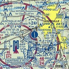
|
 Download PDF
of official airport diagram from the FAA
| Airport distance calculator |
|---|
|
|
| Sunrise and sunset |
|---|
|
Times for 01-May-2025
| | Local
(UTC-5) | | Zulu
(UTC) |
|---|
| Morning civil twilight | | 05:30 | | 10:30 |
| Sunrise | | 05:57 | | 10:57 |
| Sunset | | 19:30 | | 00:30 |
| Evening civil twilight | | 19:57 | | 00:57 |
|
| Current date and time |
|---|
| Zulu (UTC) | 01-May-2025 20:18:14 |
|---|
| Local (UTC-5) | 01-May-2025 15:18:14 |
|---|
|
| METAR |
|---|
| KHUA | 011957Z 18007KT 7SM FEW047 BKN090 28/17 A2994 RMK SLPNO RVRNO $
|
KHSV
5nm W | 011953Z 21012G20KT 10SM FEW047 BKN090 BKN250 28/15 A2995 RMK AO2 SLP133 T02780150 $
|
KMDQ
13nm NE | 011955Z AUTO 20011KT 10SM SCT037 SCT046 BKN075 27/17 A2996 RMK A02
|
KDCU
13nm W | 011953Z AUTO 19015G26KT 10SM FEW049 OVC065 27/16 A2995 RMK AO2 PK WND 18026/1953 SLP134 T02720156
|
|
| TAF |
|---|
| KHUA | 011200Z 0112/0218 19009KT 9999 SCT020 QNH2996INS BECMG 0116/0117Z 19009KT 8000 -RA BKN010 OVC020 QNH3000INS TEMPO 0117/0202 20012G20KT 6000 -TSRA BKN035CB OVC100 BECMG 0202/0203 19009KT 9000 -RA BKN019 OVC026 QNH2995INS BECMG 0213/0214 19009KT 8000 -SHRA VCTS BKN011CB OVC019 QNH2995INS TX25/0117Z TN19/021
|
KHSV
5nm W | 011732Z 0118/0218 20010G18KT P6SM VCSH SCT025 SCT080 BKN200 FM012000 22010G20KT 5SM -TSRA BR BKN050CB OVC100 TEMPO 0120/0124 2SM TSRA BR BKN025CB FM020200 20005KT P6SM SCT040 BKN130 FM020600 VRB03KT P6SM BKN250
|
|
| NOTAMs |
|---|
NOTAMs are issued by the DoD/FAA and will open in a separate window not controlled by AirNav.
|
|


