FAA INFORMATION EFFECTIVE 20 FEBRUARY 2025
Location
| FAA Identifier: | JAC |
| Lat/Long: | 43-36-26.4000N 110-44-15.9000W
43-36.440000N 110-44.265000W
43.6073333,-110.7377500
(estimated) |
| Elevation: | 6450.7 ft. / 1966.2 m (surveyed) |
| Variation: | 13E (2005) |
| From city: | 7 miles N of JACKSON, WY |
| Time zone: | UTC -7 (UTC -6 during Daylight Saving Time) |
| Zip code: | 83001 |
Airport Operations
| Airport use: | Open to the public |
| Activation date: | 10/1941 |
| Control tower: | yes |
| ARTCC: | SALT LAKE CITY CENTER |
| FSS: | CASPER FLIGHT SERVICE STATION |
| NOTAMs facility: | JAC (NOTAM-D service available) |
| Attendance: | 0700-2130
ON CALL H24 PHONE 307-733-4767. |
| Wind indicator: | lighted |
| Segmented circle: | no |
| Lights: | WHEN ATCT CLSD ACTVT MALS RWY 01 & 19; HIRL RWY 01/19; RCLS RWY 01/19; TWY LGTS; WDI - CTAF. |
| Beacon: | white-green (lighted land airport)
Operates sunset to sunrise. |
| Landing fee: | yes |
| Fire and rescue: | ARFF index B |
Airport Communications
| CTAF: | 118.075 |
| UNICOM: | 122.95 |
| WX AWOS-3PT: | PHONE 307-739-9108 |
| JACKSON GROUND: | 124.55 [0700-2130] |
| JACKSON TOWER: | 118.075 [0700-2130] |
| D-ATIS: | 120.625 |
| WX AWOS-3PT at DIJ (18 nm NW): | 120.775 (208-354-6661) |
- APCH/DEP CTL SVC PRVDD BY SALT LAKE ARTCC (ZLC) ON FREQS 133.25/285.6 (JACKSON RCAG).
Nearby radio navigation aids
| VOR radial/distance | | VOR name | | Freq | | Var |
|---|
| JAC at field | | JACKSON VOR/DME | | 115.40 | | 13E |
| DNWr218/21.9 | | DUNOIR VOR/DME | | 117.20 | | 15E |
Airport Services
| Fuel available: | 100LL JET-A |
| Parking: | hangars and tiedowns |
| Airframe service: | MINOR |
| Powerplant service: | MINOR |
| Bottled oxygen: | HIGH |
| Bulk oxygen: | NONE |
Runway Information
Runway 1/19
| Dimensions: | 6300 x 150 ft. / 1920 x 46 m |
| Surface: | asphalt/grooved, in excellent condition |
| Weight bearing capacity: | | Single wheel: | 120.0 | | Double wheel: | 187.0 | | Double tandem: | 287.0 |
|
| Runway edge lights: | high intensity |
| RUNWAY 1 | | RUNWAY 19 |
| Latitude: | 43-35.951642N | | 43-36.928795N |
| Longitude: | 110-44.503175W | | 110-44.026630W |
| Elevation: | 6412.8 ft. | | 6450.5 ft. |
| Traffic pattern: | left | | left |
| Runway heading: | 007 magnetic, 020 true | | 187 magnetic, 200 true |
| Declared distances: | TORA:6300 TODA:6300 ASDA:6300 LDA:6300 | | TORA:6300 TODA:6300 ASDA:6300 LDA:6300 |
| Markings: | precision, in good condition | | precision, in good condition |
| Visual slope indicator: | 4-light PAPI on left (3.00 degrees glide path) | | 4-light PAPI on right (3.00 degrees glide path) |
| RVR equipment: | touchdown, midfield, rollout | | touchdown, midfield, rollout |
| Approach lights: | MALS: 1,400 foot medium intensity approach lighting system | | MALS: 1,400 foot medium intensity approach lighting system |
| Runway end identifier lights: | no | | no |
| Centerline lights: | yes | | yes |
| Touchdown point: | yes, no lights | | yes, no lights |
| Instrument approach: | | | ILS/DME |
| Obstructions: | 10 ft. road, 249 ft. from runway, 505 ft. left of centerline, 5:1 slope to clear | | none |
Airport Ownership and Management from official FAA records
| Ownership: | Publicly-owned |
| Owner: | JACKSON HOLE AIRPORT BOARD
P. O. BOX 159
JACKSON, WY 83001
Phone 307-733-7682
LEASED FROM U S PARK SERVICE. |
| Manager: | JIM ELWOOD
P. O. BOX 159
JACKSON, WY 83001
Phone (307) 733-7695 |
Additional Remarks
| A39-01/19 | PCR VALUE: 508/F/C/X/T |
| - | 35'-53' TREES 700'-800' WEST OF THR RY 01. |
| - | PAVED 950X200 FT SAFETY AREA AT THE DEP END OF RWY 19; NOT USBL FOR PER CALCULATIONS; PLOWED & BROOMED DURG WINTER. |
| - | DEICING PAD LOCATED AT NORTH END OF TWY A. |
| - | COLD TEMPERATURE AIRPORT. ALTITUDE CORRECTION REQUIRED AT OR BELOW -22C. |
| - | FOR CD IF UNA TO CTC ON FSS FREQ, CTC JAC TWR GND AT 124.55 DURG NML OPRG HRS. OUTSIDE OF NML OPRG HRS, CTC SALT LAKE ARTCC AT 801-320-2568. |
| - | ACFT PUSHING BACK FM TRML CAUSE CGSTN, MAKING A2 UNAVBL. COORD RWY EXITS WITH TWR. |
| - | NOISE ABATEMENT PROCEDURES IN EFFECT FOR ACFT DEPARTURES ON RWY 19. |
| - | SAGE GROUSE ON & INVOF ARPT APR THRU OCT. |
| - | POSSIBLE SEVERE WINTER CONDITIONS FROM NOV-APR; NO ARPT INFO OR SNOW REMOVAL GUARANTEED DURING HOURS OF NON ATTENDANCE. 307-733-7682 |
| - | HANG GLIDING OPNS 9 MILES S OF ARPT NEAR SKI ARE & 9 MILES SSW OF ARPT ALONG THE RIDGE. |
| - | BALLOON OPERATIONS IN VICINITY OF AIRPORT, W AND SW, MAY-OCT. |
| - | FOR PUBLIC HEALTH & SAFETY FLIGHTS, CONTACT AMGR @ 307-733-7682. |
| - | ACFT THAT FAIL TO TOUCH DOWN WITHIN THE FIRST THIRD OF RY 01/19 SOMETIMES FAIL TO STOP ON THE RY AND ARE AT RISK FOR A RY EXCURSION. |
Instrument Procedures
NOTE: All procedures below are presented as PDF files. If you need a reader for these files, you should download the free Adobe Reader.NOT FOR NAVIGATION. Please procure official charts for flight.
FAA instrument procedures published for use from 20 February 2025 at 0901Z to 20 March 2025 at 0900Z.
IAPs - Instrument Approach Procedures |
|---|
| ILS Y OR LOC Y RWY 19 | |
download (504KB) |
| ILS Z OR LOC Z RWY 19 | |
download (531KB) |
| RNAV (RNP) X RWY 19 | |
download (378KB) |
| RNAV (RNP) Y RWY 01 | |
download (643KB) |
| RNAV (RNP) Y RWY 19 | |
download (456KB) |
| RNAV (RNP) Z RWY 01 | |
download (676KB) |
| RNAV (GPS) X RWY 01 | |
download (669KB) |
| RNAV (GPS) Z RWY 19 | |
download (458KB) |
| VOR RWY 01 | |
download (469KB) |
| VOR RWY 19 | |
download (458KB) |
| NOTE: Special Alternate Minimums apply | |
download (211KB) |
Departure Procedures |
|---|
| ALPIN FOUR | |
download (157KB) |
| DIVYD TWO (RNAV) | |
download (160KB) |
|
|---|
| GEYSER SIX (OBSTACLE) | |
download (128KB) |
| TETON THREE (OBSTACLE) | |
download (149KB) |
| NOTE: Special Take-Off Minimums/Departure Procedures apply | |
download (223KB) |
Other nearby airports with instrument procedures:
KDIJ - Driggs/Reed Memorial Airport (18 nm NW)
KDUB - Dubois Municipal Airport (46 nm E)
KRXE - Rexburg-Madison County Airport (48 nm W)
KAFO - Afton Lincoln County Airport/General Boyd L Eddins Field (55 nm S)
KIDA - Idaho Falls Regional Airport (58 nm W)
|
|

Road maps at:
MapQuest
Bing
Google
| Aerial photo |
|---|
WARNING: Photo may not be current or correct
 Photo by David Newcomer
Photo taken 30-Sep-2011
looking northwest from 4,000' AGL.
Photo by David Newcomer
Photo taken 30-Sep-2011
looking northwest from 4,000' AGL.
Do you have a better or more recent aerial photo of Jackson Hole Airport that you would like to share? If so, please send us your photo.
|
| Sectional chart |
|---|
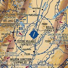
|
CAUTION: Diagram may not be current
 Download PDF
of official airport diagram from the FAA
| Airport distance calculator |
|---|
|
|
| Sunrise and sunset |
|---|
|
Times for 03-Mar-2025
| | Local
(UTC-7) | | Zulu
(UTC) |
|---|
| Morning civil twilight | | 06:28 | | 13:28 |
| Sunrise | | 06:57 | | 13:57 |
| Sunset | | 18:13 | | 01:13 |
| Evening civil twilight | | 18:42 | | 01:42 |
|
| Current date and time |
|---|
| Zulu (UTC) | 04-Mar-2025 00:19:37 |
|---|
| Local (UTC-7) | 03-Mar-2025 17:19:37 |
|---|
|
| METAR |
|---|
| KJAC | 032356Z 19004KT 1/2SM -SN FG OVC003 01/M01 A2970 RMK AO2 SLP084 P0011 60019 T00061006 10022 21011 53011
|
KDIJ
18nm NW | 032356Z AUTO 04008KT 10SM OVC031 01/M02 A2974 RMK AO2 SLP084 T00111022 10039 20006 53016 $
|
|
| TAF |
|---|
| KJAC | 032047Z 0321/0418 05003KT 4SM -SHSN BKN010 OVC025 TEMPO 0322/0402 1SM -SN SCT003 BKN005 OVC010 FM040300 03005KT 5SM -SHSN BKN015 OVC030 FM040500 03007KT P6SM SCT045 BKN060
|
KDIJ
18nm NW | 032016Z 0320/0418 31007KT 6SM BR VCSH SCT005 BKN045 OVC080 FM040600 VRB05KT P6SM OVC010 AMD LTD TO CLD VIS AND WIND
|
|
| NOTAMs |
|---|
NOTAMs are issued by the DoD/FAA and will open in a separate window not controlled by AirNav.
|
|


