FAA INFORMATION EFFECTIVE 17 APRIL 2025
Location
| FAA Identifier: | LCQ |
| Lat/Long: | 30-10-55.4000N 082-34-36.7000W
30-10.923333N 082-34.611667W
30.1820556,-82.5768611
(estimated) |
| Elevation: | 200.7 ft. / 61.2 m (surveyed) |
| Variation: | 03W (1990) |
| From city: | 3 miles E of LAKE CITY, FL |
| Time zone: | UTC -4 (UTC -5 during Standard Time) |
| Zip code: | 32025 |
Airport Operations
| Airport use: | Open to the public |
| Activation date: | 04/1940 |
| Control tower: | yes |
| ARTCC: | JACKSONVILLE CENTER |
| FSS: | GAINESVILLE FLIGHT SERVICE STATION |
| NOTAMs facility: | GNV (NOTAM-D service available) |
| Attendance: | 0800-1800
TWR ATNDD OTR TIMES BY NOTAM. |
| Wind indicator: | lighted |
| Segmented circle: | yes |
| Lights: | ACTVT REIL RWY 10 & 28; MIRL RWY 5/23 & 10/28 - CTAF. |
| Beacon: | white-green (lighted land airport)
Operates sunset to sunrise. |
Airport Communications
| CTAF: | 119.2 |
| UNICOM: | 122.95 |
| WX AWOS-3: | 120.675 (386-754-9366) |
| LAKE CITY GROUND: | 121.9 [0800-1630 MON-FRI] |
| LAKE CITY TOWER: | 119.2 314.6 [0800-1630 MON-FRI] |
| EMERG: | 121.5 |
- APCH/DEP SVC PRVDD BY JACKSONVILLE ARTCC ON FREQS 125.375/254.325 (LAKE CITY RCAG).
- ATCT MAY BE OPEN AT OTHER THAN PUBLISHED HRS; MONITOR CTAF AT ALL TIMES.
Nearby radio navigation aids
| VOR radial/distance | | VOR name | | Freq | | Var |
|---|
| TAYr187/19.4 | | TAYLOR VORTAC | | 112.90 | | 03W |
| GNVr336/33.4 | | GATORS VORTAC | | 116.20 | | 04W |
Airport Services
| Fuel available: | 100LL JET-A |
| Parking: | hangars and tiedowns |
| Airframe service: | MINOR |
| Powerplant service: | MINOR |
| Bottled oxygen: | NONE |
| Bulk oxygen: | NONE |
Runway Information
Runway 10/28
| Dimensions: | 8003 x 150 ft. / 2439 x 46 m |
| Surface: | asphalt, in good condition |
| Weight bearing capacity: | | PCN 42 /F/A/W/T | | Single wheel: | 75.0 | | Double wheel: | 105.0 | | Double tandem: | 250.0 |
|
| Runway edge lights: | medium intensity |
| RUNWAY 10 | | RUNWAY 28 |
| Latitude: | 30-11.043577N | | 30-10.881588N |
| Longitude: | 082-35.407263W | | 082-33.899262W |
| Elevation: | 198.1 ft. | | 196.3 ft. |
| Traffic pattern: | left | | right |
| Runway heading: | 100 magnetic, 097 true | | 280 magnetic, 277 true |
| Markings: | nonprecision, in fair condition | | nonprecision, in fair condition |
| Visual slope indicator: | 2-light PAPI on left (3.00 degrees glide path) | | 2-light PAPI on left (3.00 degrees glide path) |
| Runway end identifier lights: | yes | | yes |
| Touchdown point: | yes, no lights | | yes, no lights |
| Obstructions: | 57 ft. trees, 1425 ft. from runway, 170 ft. left of centerline, 21:1 slope to clear | | 48 ft. trees, 1885 ft. from runway, 250 ft. right of centerline, 35:1 slope to clear |
Runway 5/23
| Dimensions: | 4000 x 75 ft. / 1219 x 23 m |
| Surface: | asphalt, in excellent condition |
| Runway edge lights: | medium intensity |
| RUNWAY 5 | | RUNWAY 23 |
| Latitude: | 30-10.640550N | | 30-11.046487N |
| Longitude: | 082-34.829658W | | 082-34.230573W |
| Elevation: | 185.5 ft. | | 194.8 ft. |
| Traffic pattern: | left | | left |
| Runway heading: | 055 magnetic, 052 true | | 235 magnetic, 232 true |
| Markings: | nonprecision, in good condition | | nonprecision, in good condition |
| Touchdown point: | yes, no lights | | yes, no lights |
| Obstructions: | 64 ft. trees, 1690 ft. from runway, 250 ft. right of centerline, 23:1 slope to clear | | 50 ft. trees, 1625 ft. from runway, 265 ft. left of centerline, 28:1 slope to clear |
Airport Ownership and Management from official FAA records
| Ownership: | Publicly-owned |
| Owner: | CITY OF LAKE CITY
205 NORTH MARION AVE
LAKE CITY, FL 32055
Phone 386-719-5785
CTC PERSON: DEMETRIUS JOHNSON |
| Manager: | ED BUNNELL
3524 E US HWY 90
LAKE CITY, FL 32055
Phone 386-752-1066 |
Additional Remarks
| A39-05/23 | PCR VALUE: 11/F/A/Y/T |
| - | UNLIT 60 FT POLES ON MOVEMENT AREA. HELICOPTERS ADVISED TO TAXI ON PAVED AREAS ONLY. |
| - | WHEN ATCT CLSD, FOR CD CTC JACKSONVILLE ARTCC AT 904-845-1592. |
Instrument Procedures
NOTE: All procedures below are presented as PDF files. If you need a reader for these files, you should download the free Adobe Reader.NOT FOR NAVIGATION. Please procure official charts for flight.
FAA instrument procedures published for use from 17 April 2025 at 0901Z to 15 May 2025 at 0900z.
IAPs - Instrument Approach Procedures |
|---|
| RNAV (GPS) RWY 10 | |
download (216KB) |
| RNAV (GPS) RWY 28 | |
download (272KB) |
| NOTE: Special Alternate Minimums apply | |
download (124KB) |
| NOTE: Special Take-Off Minimums/Departure Procedures apply | |
download |
Other nearby airports with instrument procedures:
24J - Suwannee County Airport (24 nm W)
KGNV - Gainesville Regional Airport (34 nm SE)
42J - Keystone Heights Airport (34 nm SE)
KVQQ - Cecil Airport (36 nm E)
KHEG - Herlong Recreational Airport (40 nm E)
|
|

Road maps at:
MapQuest
Bing
Google
| Aerial photo |
|---|
WARNING: Photo may not be current or correct

Do you have a better or more recent aerial photo of Lake City Gateway Airport that you would like to share? If so, please send us your photo.
|
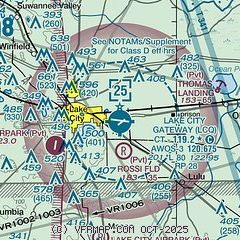
| Sectional chart |
|---|
|
| Airport distance calculator |
|---|
|
|
| Sunrise and sunset |
|---|
|
Times for 19-Apr-2025
| | Local
(UTC-4) | | Zulu
(UTC) |
|---|
| Morning civil twilight | | 06:35 | | 10:35 |
| Sunrise | | 07:00 | | 11:00 |
| Sunset | | 19:59 | | 23:59 |
| Evening civil twilight | | 20:24 | | 00:24 |
|
| Current date and time |
|---|
| Zulu (UTC) | 19-Apr-2025 20:07:26 |
|---|
| Local (UTC-4) | 19-Apr-2025 16:07:26 |
|---|
|
| METAR |
|---|
| KLCQ | 191955Z AUTO 13008KT 10SM CLR 30/12 A3023 RMK AO2
|
|
| TAF |
|---|
KGNV
33nm SE | 191720Z 1918/2018 12011G17KT P6SM FEW050 FM200000 12006KT P6SM SKC FM200600 VRB02KT P6SM SCT250 FM201500 14010G15KT P6SM SCT250
|
KVQQ
36nm E | 191720Z 1918/2018 13012G18KT P6SM FEW040 FM200000 14006KT P6SM SKC FM200600 00000KT P6SM SCT250 TEMPO 2007/2011 3SM BR FM201500 15010G15KT P6SM SCT250
|
|
| NOTAMs |
|---|
NOTAMs are issued by the DoD/FAA and will open in a separate window not controlled by AirNav.
|
|


