FAA INFORMATION EFFECTIVE 20 FEBRUARY 2025
Location
| FAA Identifier: | LMT |
| Lat/Long: | 42-09-22.1180N 121-43-59.5370W
42-09.368633N 121-43.992283W
42.1561439,-121.7332047
(estimated) |
| Elevation: | 4095.4 ft. / 1248.3 m (surveyed) |
| Variation: | 14E (2025) |
| From city: | 4 miles SE of KLAMATH FALLS, OR |
| Time zone: | UTC -8 (UTC -7 during Daylight Saving Time) |
| Zip code: | 97603 |
Airport Operations
| Airport use: | Open to the public |
| Activation date: | 11/1937 |
| Control tower: | yes |
| ARTCC: | SEATTLE CENTER |
| FSS: | MC MINNVILLE FLIGHT SERVICE STATION |
| NOTAMs facility: | LMT (NOTAM-D service available) |
| Attendance: | MON-FRI 0630-1700
UNATNDD WKEND & HOL. |
| Wind indicator: | lighted |
| Segmented circle: | yes |
| Lights: | WHEN ATCT CLSD ACTVT MALSF RWY 14, MALSR RWY 32, HIRL RWY 14/32, MIRL RWY 08/26 & TWY LGTS - CTAF. RWY & TWY LGTS ALSO ACTVT ON 257.8. REIL RWY 26; PAPI RWY 26, PAPI RWY 14 & VASI RWY 32 OPR CONSLY. |
| Beacon: | white-green (lighted land airport)
Operates sunset to sunrise. |
| Landing fee: | yes |
| Fire and rescue: | ARFF index A |
Airport Communications
| CTAF: | 133.975 |
| UNICOM: | 122.95 |
| ATIS: | 126.5 263.0 |
| WX ASOS: | PHONE 541-883-8127 |
| KINGSLEY GROUND: | 121.9 348.6 [0700-2000] |
| KINGSLEY TOWER: | 133.975 257.8 [0700-2000] |
| KINGSLEY APPROACH: | 123.675 270.8 [MON-FRI 0800-1600 EXC WKENDS AND HOL.] |
| KINGSLEY DEPARTURE: | 123.675 270.8 [MON-FRI 0800-1600 EXC WKENDS AND HOL.] |
| ANG OPS: | 388.95 |
| COMD POST: | 298.4 |
| EMERG: | 121.5 |
- APCH/DEP CTL SVC PRVDD BY SEATTLE ARTCC (ZSE) ON FREQS 127.6/346.35 (KLAMATH FALLS RCAG) WHEN KINGSLEY APCH (LMT) CLSD.
- ATCT MAY OPERATE AT OTHER TIMES BY NOTAM AS REQUIRED FOR MILITARY ACTIVITIES.
Nearby radio navigation aids
| VOR radial/distance | | VOR name | | Freq | | Var |
|---|
| LMT at field | | KLAMATH FALLS VORTAC | | 115.90 | | 17E |
Airport Services
| Fuel available: | 100LL JET-A JET-A++ |
| Parking: | hangars and tiedowns |
| Airframe service: | MAJOR |
| Powerplant service: | MAJOR |
| Bottled oxygen: | HIGH |
| Bulk oxygen: | HIGH |
Runway Information
Runway 14/32
| Dimensions: | 10302 x 150 ft. / 3140 x 46 m |
| Surface: | asphalt/concrete/grooved, in good condition |
| Weight bearing capacity: | | Single wheel: | 120.0 | | Double wheel: | 243.0 | | Double tandem: | 474.0 | | Dual double tandem: | 970.0 |
|
| Runway edge lights: | high intensity |
| RUNWAY 14 | | RUNWAY 32 |
| Latitude: | 42-10.152295N | | 42-08.577477N |
| Longitude: | 121-44.424328W | | 121-43.578923W |
| Elevation: | 4091.0 ft. | | 4095.4 ft. |
| Traffic pattern: | left | | left |
| Runway heading: | 144 magnetic, 158 true | | 324 magnetic, 338 true |
| Declared distances: | TORA:10302 TODA:10302 ASDA:10302 LDA:10302 | | TORA:10302 TODA:10302 ASDA:10302 LDA:10302 |
| Markings: | precision, in good condition | | precision, in fair condition |
| Visual slope indicator: | 4-light PAPI on left (3.20 degrees glide path)
RWY 14 PAPI UNUSBL BYD 3.5 NM. | | 4-box VASI on left (3.00 degrees glide path) |
| RVR equipment: | rollout | | touchdown |
| Approach lights: | MALSF: 1,400 foot medium intensity approach lighting system with sequenced flashers | | MALSR: 1,400 foot medium intensity approach lighting system with runway alignment indicator lights |
| Touchdown point: | yes, no lights | | yes, no lights |
| Instrument approach: | | | ILS |
Runway 8/26
| Dimensions: | 5258 x 100 ft. / 1603 x 30 m |
| Surface: | asphalt/grooved, in good condition |
| Weight bearing capacity: | | Single wheel: | 41.0 | | Double wheel: | 68.0 | | Double tandem: | 116.0 |
|
| Runway edge lights: | medium intensity |
| RUNWAY 8 | | RUNWAY 26 |
| Latitude: | 42-09.379118N | | 42-09.372875N |
| Longitude: | 121-44.555740W | | 121-43.392607W |
| Elevation: | 4091.9 ft. | | 4089.1 ft. |
| Traffic pattern: | left | | left |
| Runway heading: | 076 magnetic, 090 true | | 256 magnetic, 270 true |
| Displaced threshold: | 306 ft. | | 512 ft. |
| Declared distances: | TORA:5258 TODA:5258 ASDA:5258 LDA:4952 | | TORA:5258 TODA:5258 ASDA:5258 LDA:4746 |
| Markings: | nonprecision, in good condition | | nonprecision, in good condition |
| Visual slope indicator: | | | 4-light PAPI on left (2.83 degrees glide path) |
| Runway end identifier lights: | | | yes |
| Touchdown point: | yes, no lights | | yes, no lights |
| Obstructions: | 25 ft. rr, 625 ft. from runway, 125 ft. right of centerline, 16:1 slope to clear
APCH SLOPE 29:1 TO DTHR. | | 8 ft. fence, 86 ft. from runway, 125 ft. right of centerline
APCH SLOPE 34:1 TO DTHR. |
Airport Ownership and Management from official FAA records
| Ownership: | Publicly-owned |
| Owner: | CITY OF KLAMATH FALLS
CITY HALL PO BOX 237
KLAMATH FALLS, OR 97601
Phone 541-883-5316 |
| Manager: | JONATHAN TEICHERT
3000 AIRPORT WAY STE. 300
KLAMATH FALLS, OR 97603
Phone 541-883-5373
541-539-8977. |
Additional Remarks
| A39-14/32 | PCR VALUE: 560/F/A/W/T |
| A39-08/26 | PCR VALUE: 110/F/A/X/T |
| E60-32 | TYPE H BAK-12B(B)(1500') |
| E60-14 | TYPE H BAK-12B(B)(1500') |
| - | WATERFOWL INVOF ARPT NOV-MAY. |
| - | OFFL BUS PPR - D830-6686. BASE OPS 1400-2359Z++ WKDAYS; CLSD HOL. |
| - | MIL FUEL SVC 1500-0300Z++; 20 MIN PRIOR NOTICE & FEE - C541-882-4681 |
| - | MIL BASH PHASE II - FEB - MAY & SEP - NOV. OTR TIMES BASH PHASE I. |
| - | RSTD: TWY A WEST OF TWY D & TWY D BTN TWY E & F MIL OPS ONLY. |
| - | FBO - 541-882-4681. |
| - | TWY G SOUTH RUN UP PAD MIL OPS ONLY. |
| - | CONDS UNMTR WKDAY 2230 - 0630, WKEND & HOL. |
| - | FOR CD IF UNA TO CTC ON FSS FREQ, CTC SEATTLE ARTCC AT 253-351-3694. |
| - | MIL ANG: CLASSIFIED MTRL STORAGE SECRET & BLW - AMGMT. |
| - | TWY B BTN TWY B1 & B2 WINGTIP TO FIXED OBJECT SEPN NONSTD; WINGSPAN GTR THAN 133 FT MINIMIZE TAX SPD. |
| - | MIL ANG: HVY ACFT AFT LNDG TAX TO N OR S EOR; SHTDN OUTBOARD ENGS BFR TAX TO MIL RAMP. |
| - | CSTMS/AG/IMG SVC NA. KPDX CUST - C503-326-3249. |
Instrument Procedures
NOTE: All procedures below are presented as PDF files. If you need a reader for these files, you should download the free Adobe Reader.NOT FOR NAVIGATION. Please procure official charts for flight.
FAA instrument procedures published for use from 20 February 2025 at 0901Z to 20 March 2025 at 0900Z.
IAPs - Instrument Approach Procedures |
|---|
| HI-ILS Z OR LOC Z RWY 32 **CHANGED** | |
download (210KB) |
| ILS Y OR LOC Y RWY 32 | |
download (306KB) |
| RNAV (GPS) RWY 14 | |
download (297KB) |
| RNAV (GPS) RWY 32 | |
download (316KB) |
| VOR/DME OR TACAN RWY 14 | |
download (355KB) |
| VOR/DME OR TACAN RWY 32 | |
download (314KB) |
| HI-TACAN RWY 14 **CHANGED** | |
download (207KB) |
| HI-TACAN RWY 32 **CHANGED** | |
download (211KB) |
| NOTE: Special Alternate Minimums apply | |
download (212KB) |
Departure Procedures |
|---|
| KINGSLEY SEVEN | |
download (232KB) |
|
|---|
| CRATER ONE (OBSTACLE) | |
download (363KB) |
| NOTE: Special Take-Off Minimums/Departure Procedures apply | |
download (559KB) |
Other nearby airports with instrument procedures:
KSIY - Siskiyou County Airport (40 nm SW)
O46 - Weed Airport (52 nm SW)
KMFR - Rogue Valley International/Medford Airport (52 nm W)
KLKV - Lake County Airport (59 nm E)
KAAT - Alturas Municipal Airport (66 nm SE)
|
|

Road maps at:
MapQuest
Bing
Google
| Aerial photo |
|---|
WARNING: Photo may not be current or correct

Do you have a better or more recent aerial photo of Crater Lake/Klamath Regional Airport that you would like to share? If so, please send us your photo.
|
| Sectional chart |
|---|
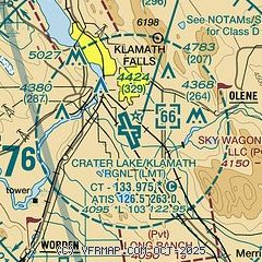
|
 Download PDF
of official airport diagram from the FAA
| Airport distance calculator |
|---|
|
|
| Sunrise and sunset |
|---|
|
Times for 13-Mar-2025
| | Local
(UTC-8) | | Zulu
(UTC) |
|---|
| Morning civil twilight | | 05:55 | | 13:55 |
| Sunrise | | 06:23 | | 14:23 |
| Sunset | | 18:10 | | 02:10 |
| Evening civil twilight | | 18:38 | | 02:38 |
|
| Current date and time |
|---|
| Zulu (UTC) | 13-Mar-2025 15:55:44 |
|---|
| Local (UTC-8) | 13-Mar-2025 07:55:44 |
|---|
|
| METAR |
|---|
| KLMT | 131453Z 17003KT 10SM FEW029 SCT034 OVC042 M01/M03 A2960 RMK AO2 SLP031 T10061033 53015
|
|
| TAF |
|---|
| KLMT | 131126Z 1312/1412 19006KT P6SM BKN035 FM131800 28010G15KT P6SM VCSH BKN050 FM140600 VRB03KT P6SM OVC100
|
|
| NOTAMs |
|---|
NOTAMs are issued by the DoD/FAA and will open in a separate window not controlled by AirNav.
|
|


