FAA INFORMATION EFFECTIVE 20 FEBRUARY 2025
Location
| FAA Identifier: | MIW |
| Lat/Long: | 42-06-45.9000N 092-55-04.0000W
42-06.765000N 092-55.066667W
42.1127500,-92.9177778
(estimated) |
| Elevation: | 974.6 ft. / 297.1 m (surveyed) |
| Variation: | 01E (2010) |
| From city: | 3 miles N of MARSHALLTOWN, IA |
| Time zone: | UTC -6 (UTC -5 during Daylight Saving Time) |
| Zip code: | 50158 |
Airport Operations
| Airport use: | Open to the public |
| Activation date: | 12/1946 |
| Control tower: | no |
| ARTCC: | MINNEAPOLIS CENTER |
| FSS: | FORT DODGE FLIGHT SERVICE STATION |
| NOTAMs facility: | MIW (NOTAM-D service available) |
| Attendance: | 0800-1700
FOR ARPT ATTENDANT AFTER HRS CALL 641-521-6832. |
| Wind indicator: | lighted |
| Segmented circle: | no |
| Lights: | ACTVT MIRL RY 13/31 & RY 18/36; REIL & VASI RYS 13 & 31 - CTAF. |
| Beacon: | white-green (lighted land airport)
Operates sunset to sunrise. |
Airport Communications
| CTAF/UNICOM: | 122.8 |
| WX ASOS: | 128.325 (641-752-2339) |
| WATERLOO APPROACH: | 120.9 |
| WATERLOO DEPARTURE: | 120.9 |
| CLEARANCE DELIVERY: | 120.9 |
- APCH/DEP SVC PRVDD BY MINNEAPOLIS ARTCC ON FREQ 118.9 (REMOTED FROM WATERLOO) WHEN WATERLOO APCH CTL CLSD.
Nearby radio navigation aids
| VOR radial/distance | | VOR name | | Freq | | Var |
|---|
| TNUr020/21.5 | | NEWTON VOR/DME | | 112.50 | | 03E |
| ALOr221/35.2 | | WATERLOO VOR/DME | | 112.20 | | 00E |
Airport Services
| Fuel available: | 100LL JET-A |
| Parking: | hangars and tiedowns |
| Airframe service: | MAJOR |
| Powerplant service: | MAJOR |
| Bottled oxygen: | LOW |
Runway Information
Runway 13/31
| Dimensions: | 5007 x 100 ft. / 1526 x 30 m |
| Surface: | asphalt, in fair condition |
| Weight bearing capacity: | | PCN 32 /F/C/X/T | | Single wheel: | 35.0 | | Double wheel: | 42.0 |
|
| Runway edge lights: | medium intensity |
| RUNWAY 13 | | RUNWAY 31 |
| Latitude: | 42-07.020693N | | 42-06.523808N |
| Longitude: | 092-55.441398W | | 092-54.557918W |
| Elevation: | 974.3 ft. | | 971.6 ft. |
| Traffic pattern: | left | | left |
| Runway heading: | 126 magnetic, 127 true | | 306 magnetic, 307 true |
| Markings: | nonprecision, in fair condition | | nonprecision, in fair condition |
| Visual slope indicator: | 4-box VASI on left (3.00 degrees glide path) | | 4-box VASI on left (3.00 degrees glide path) |
| Runway end identifier lights: | yes | | yes |
| Touchdown point: | yes, no lights | | yes, no lights |
Runway 18/36
| Dimensions: | 2759 x 50 ft. / 841 x 15 m |
| Surface: | asphalt, in fair condition |
| Weight bearing capacity: | | PCN 26 /F/C/X/T | | Single wheel: | 15.0 |
|
| Runway edge lights: | medium intensity |
| RUNWAY 18 | | RUNWAY 36 |
| Latitude: | 42-06.978353N | | 42-06.524945N |
| Longitude: | 092-55.168675W | | 092-55.206498W |
| Elevation: | 971.0 ft. | | 968.1 ft. |
| Traffic pattern: | left | | left |
| Runway heading: | 183 magnetic, 184 true | | 003 magnetic, 004 true |
| Markings: | basic, in good condition | | basic, in good condition |
| Touchdown point: | yes, no lights | | yes, no lights |
| Obstructions: | 15 ft. road, 580 ft. from runway, 25:1 slope to clear | | 19 ft. road, 595 ft. from runway, 20:1 slope to clear |
Airport Ownership and Management from official FAA records
| Ownership: | Publicly-owned |
| Owner: | CITY OF MARSHALLTOWN
PO BOX 757
MARSHALLTOWN, IA 50158
Phone 641-754-0012 |
| Manager: | STEPHEN VALBRACHT
2651 170TH ST
MARSHALLTOWN, IA 50158
Phone 641-752-0012
STEVE |
Additional Remarks
| A52-13 | CROPS |
| - | FOR CD CTC WATERLOO APCH 319-233-4835. WHEN WATERLOO APCH CLSD, FOR CD CTC MINNEAPOLIS ARTCC AT 651-463-5588. |
Instrument Procedures
NOTE: All procedures below are presented as PDF files. If you need a reader for these files, you should download the free Adobe Reader.NOT FOR NAVIGATION. Please procure official charts for flight.
FAA instrument procedures published for use from 20 February 2025 at 0901Z to 20 March 2025 at 0900Z.
IAPs - Instrument Approach Procedures |
|---|
| RNAV (GPS) RWY 13 | |
download (227KB) |
| RNAV (GPS) RWY 31 | |
download (238KB) |
| NOTE: Special Alternate Minimums apply | |
download (146KB) |
| NOTE: Special Take-Off Minimums/Departure Procedures apply | |
download (166KB) |
Other nearby airports with instrument procedures:
KGGI - Grinnell Regional Airport (25 nm S)
KIFA - Iowa Falls Municipal Airport (27 nm NW)
KTNU - Newton Municipal Airport-Earl Johnson Field (27 nm S)
KTZT - Belle Plaine Municipal Airport (32 nm SE)
KAMW - Ames Municipal Airport (32 nm W)
|
|

Road maps at:
MapQuest
Bing
Google
| Aerial photo |
|---|
WARNING: Photo may not be current or correct
 Photo taken 07-Jul-2008
looking south
Photo taken 07-Jul-2008
looking south
Do you have a better or more recent aerial photo of Marshalltown Municipal Airport that you would like to share? If so, please send us your photo.
|
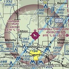
| Sectional chart |
|---|
|
| Airport distance calculator |
|---|
|
|
| Sunrise and sunset |
|---|
|
Times for 10-Mar-2025
| | Local
(UTC-6) | | Zulu
(UTC) |
|---|
| Morning civil twilight | | 06:05 | | 12:05 |
| Sunrise | | 06:33 | | 12:33 |
| Sunset | | 18:11 | | 00:11 |
| Evening civil twilight | | 18:39 | | 00:39 |
|
| Current date and time |
|---|
| Zulu (UTC) | 10-Mar-2025 11:01:05 |
|---|
| Local (UTC-6) | 10-Mar-2025 05:01:05 |
|---|
|
| METAR |
|---|
| KMIW | 101053Z AUTO 22005KT 10SM CLR 03/M01 A2982 RMK AO2 SLP101 T00281006
|
|
| TAF |
|---|
KALO
35nm NE | 100520Z 1006/1106 24009KT P6SM FEW250 FM101600 20010G18KT P6SM FEW250 FM101900 22018G30KT P6SM FEW250 FM110100 23008KT P6SM FEW250
|
|
| NOTAMs |
|---|
NOTAMs are issued by the DoD/FAA and will open in a separate window not controlled by AirNav.
|
|


