FAA INFORMATION EFFECTIVE 20 FEBRUARY 2025
Location
| FAA Identifier: | MLT |
| Lat/Long: | 45-38-52.2000N 068-41-08.0000W
45-38.870000N 068-41.133333W
45.6478333,-68.6855556
(estimated) |
| Elevation: | 408.1 ft. / 124.4 m (surveyed) |
| Variation: | 17W (2010) |
| From city: | 1 mile SE of MILLINOCKET, ME |
| Time zone: | UTC -5 (UTC -4 during Daylight Saving Time) |
| Zip code: | 04462 |
Airport Operations
| Airport use: | Open to the public |
| Activation date: | 04/1940 |
| Control tower: | no |
| ARTCC: | BOSTON CENTER |
| FSS: | BANGOR FLIGHT SERVICE STATION |
| NOTAMs facility: | MLT (NOTAM-D service available) |
| Attendance: | MAY-NOV MON-FRI 0800-1600, MAY-NOV SAT-SUN 0800-1600, DEC-APR MON-FRI 0800-1600, DEC-APR SAT-SUN UNATNDD |
| Wind indicator: | lighted |
| Segmented circle: | no |
| Lights: | ACTVT REIL RWY 29; VASI RWY 29; MIRL RWY 11/29 - CTAF. |
| Beacon: | white-green (lighted land airport)
Operates sunset to sunrise. |
Airport Communications
| CTAF/UNICOM: | 122.8 |
| WX ASOS: | 135.225 (207-723-8396) |
- APCH/DEP SVC PRVDD BY BOSTON ARTCC ON FREQS 120.25/346.4 (BANGOR RCAG).
Nearby radio navigation aids
| VOR radial/distance | | VOR name | | Freq | | Var |
|---|
| MLTr317/8.0 | | MILLINOCKET VOR/DME | | 117.90 | | 20W |
| NDB name | | Hdg/Dist | | Freq | | Var | | ID |
|---|
| MILNOT | | 287/5.7 | | 344 | | 17W | | LNT | .-.. -. - |
Airport Services
| Fuel available: | 100LL JET-A
100LL:FUEL AVBL 24 HRS WITH CREDIT CARD. JET A AVBL AFT HRS 207-723-4375 OR 207-723-6649. |
| Parking: | hangars and tiedowns |
| Airframe service: | NONE |
| Powerplant service: | NONE |
| Bottled oxygen: | NONE |
| Bulk oxygen: | NONE |
Runway Information
Runway 11/29
| Dimensions: | 4713 x 99 ft. / 1437 x 30 m |
| Surface: | asphalt, in fair condition |
| Weight bearing capacity: | | Single wheel: | 30.0 | | Double wheel: | 44.0 |
|
| Runway edge lights: | medium intensity |
| Runway edge markings: | FADED. |
| RUNWAY 11 | | RUNWAY 29 |
| Latitude: | 45-38.962273N | | 45-38.957452N |
| Longitude: | 068-41.567702W | | 068-40.462082W |
| Elevation: | 400.9 ft. | | 395.1 ft. |
| Traffic pattern: | left | | left |
| Runway heading: | 107 magnetic, 090 true | | 287 magnetic, 270 true |
| Markings: | nonprecision, in poor condition | | nonprecision, in poor condition |
| Visual slope indicator: | | | 4-box VASI on right (3.00 degrees glide path) |
| Runway end identifier lights: | no | | yes |
| Touchdown point: | yes, no lights | | yes, no lights |
| Instrument approach: | | | LOCALIZER |
| Obstructions: | 27 ft. bldg, lighted, 465 ft. from runway, 240 ft. right of centerline, 9:1 slope to clear | | none
8 FT BRUSH, 30-110 FT FM THR, 130-250 FT L OF CNTRLN. |
Runway 16/34
| Dimensions: | 4000 x 100 ft. / 1219 x 30 m |
| Surface: | asphalt, in fair condition |
| Weight bearing capacity: | | Single wheel: | 30.0 | | Double wheel: | 44.0 |
|
| Runway edge markings: | FADED. |
| RUNWAY 16 | | RUNWAY 34 |
| Latitude: | 45-39.011857N | | 45-38.515630N |
| Longitude: | 068-41.580288W | | 068-40.963893W |
| Elevation: | 400.3 ft. | | 379.9 ft. |
| Traffic pattern: | left | | left |
| Runway heading: | 156 magnetic, 139 true | | 336 magnetic, 319 true |
| Markings: | basic, in poor condition | | basic, in poor condition |
| Runway end identifier lights: | no | | no |
| Touchdown point: | yes, no lights | | yes, no lights |
| Obstructions: | 51 ft. trees, 1180 ft. from runway, 45 ft. right of centerline, 19:1 slope to clear | | 15 ft. road, 255 ft. from runway, 130 ft. left of centerline, 3:1 slope to clear |
Airport Ownership and Management from official FAA records
| Ownership: | Publicly-owned |
| Owner: | TOWN OF MILLINOCKET
197 PENOBSCOT AVE
MILLINOCKET, ME 04462
Phone 207-723-6649 |
| Manager: | JEFF CAMPBELL
MILLINOCKET MUNICIPAL ARPT, 271 MEDWAY ROAD
MILLINOCKET, ME 04462
Phone 207-723-6649 |
Additional Remarks
| - | FOR CD IF UNA TO CTC ON FSS FREQ, CTC BOSTON ARTCC AT 603-879-6859 . |
| - | WILDLIFE ON AND INVOF ARPT. |
| - | +782 FT MSL COM/AIR QLTY MNT TWR LCTD APRXLY 5200 FT FM THR OF RWY 11 AT 247 DEGS. |
Instrument Procedures
NOTE: All procedures below are presented as PDF files. If you need a reader for these files, you should download the free Adobe Reader.NOT FOR NAVIGATION. Please procure official charts for flight.
FAA instrument procedures published for use from 20 February 2025 at 0901Z to 20 March 2025 at 0900Z.
IAPs - Instrument Approach Procedures |
|---|
| RNAV (GPS) RWY 11 | |
download (263KB) |
| RNAV (GPS) RWY 29 | |
download (274KB) |
| VOR RWY 29 | |
download (261KB) |
| NOTE: Special Alternate Minimums apply | |
download (129KB) |
| NOTE: Special Take-Off Minimums/Departure Procedures apply | |
download (178KB) |
Other nearby airports with instrument procedures:
KLRG - Lincoln Regional Airport (18 nm S)
3B1 - Greenville Municipal Airport (38 nm W)
52B - Moosehead Aero Marine Seaplane Base (40 nm W)
KOLD - Dewitt Field/Old Town Municipal Airport (42 nm S)
1B0 - Dexter Regional Airport (45 nm SW)
|
|

Road maps at:
MapQuest
Bing
Google
| Aerial photo |
|---|
WARNING: Photo may not be current or correct

Do you have a better or more recent aerial photo of Millinocket Municipal Airport that you would like to share? If so, please send us your photo.
|
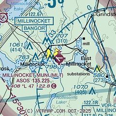
| Sectional chart |
|---|
|
| Airport distance calculator |
|---|
|
|
| Sunrise and sunset |
|---|
|
Times for 16-Mar-2025
| | Local
(UTC-4) | | Zulu
(UTC) |
|---|
| Morning civil twilight | | 06:17 | | 10:17 |
| Sunrise | | 06:47 | | 10:47 |
| Sunset | | 18:40 | | 22:40 |
| Evening civil twilight | | 19:10 | | 23:10 |
|
| Current date and time |
|---|
| Zulu (UTC) | 16-Mar-2025 17:58:40 |
|---|
| Local (UTC-4) | 16-Mar-2025 13:58:40 |
|---|
|
| METAR |
|---|
| KMLT | 161753Z AUTO 18009G16KT 10SM OVC006 10/08 A2997 RMK AO2 SLP157 T01000078 10106 20033 58017
|
|
| TAF |
|---|
KHUL
46nm NE | 161137Z 1612/1712 18010KT 2SM -DZ BR OVC003 WS020/23040KT FM161800 18012G22KT 6SM BR OVC007 WS020/23045KT FM170000 18015G25KT 5SM BR OVC010 WS020/23050KT FM170800 18015G25KT 3SM -RA BR OVC006 WS020/23050KT
|
|
| NOTAMs |
|---|
NOTAMs are issued by the DoD/FAA and will open in a separate window not controlled by AirNav.
|
|


