FAA INFORMATION EFFECTIVE 20 FEBRUARY 2025
Location
| FAA Identifier: | NJK |
| Lat/Long: | 32-49-35.8781N 115-40-06.8283W
32-49.597968N 115-40.113805W
32.8266328,-115.6685634
(estimated) |
| Elevation: | -42.5 ft. / -13 m (estimated) |
| Variation: | 11E (2015) |
| From city: | 6 miles NW of EL CENTRO, CA |
| Time zone: | UTC -8 (UTC -7 during Daylight Saving Time) |
| Zip code: | 92243 |
Airport Operations
| Airport use: | Private use. Permission required prior to landing |
| Activation date: | 02/1973 |
| Control tower: | yes |
| ARTCC: | LOS ANGELES CENTER |
| FSS: | SAN DIEGO FLIGHT SERVICE STATION |
| NOTAMs facility: | NJK (NOTAM-D service available) |
| Attendance: | MON-THU 1500-0700Z++, ALL FRI 1500-0200Z++, ALL SAT 1500-2300Z++
CLSD SUN AND HOL. |
| Segmented circle: | no |
| Lights: | AVBL ONLY DURING HRS OF OPERATION. |
| Beacon: | white-white-green (lighted military airport)
Operates sunset to sunrise. |
Airport Communications
| ATIS: | 269.275 |
| EL CENTRO GROUND: | 121.9 254.35 [1500-0700Z++ MON-THU; 1500-0200Z++ FRI; 1500-2300Z++ SAT; CLSD SUN AND HOL.] |
| EL CENTRO TOWER: | 119.1 360.2 [1500-0700Z++ MON-THU; 1500-0200Z++ FRI; 1500-2300Z++ SAT; CLSD SUN AND HOL.] |
| CLEARANCE DELIVERY: | 340.2 |
| EMERG: | 121.5 243.0 |
| PMSV METRO: | 348.3 |
| WX ASOS at IPL (5 nm E): | 132.175 (760-355-2851) |
- APCH/DEP CTL SVC PRVDD BY YUMA CERAP (ZYL) ON 128.55/292.2 (EL CENTRO RCAG).
Nearby radio navigation aids
| VOR radial/distance | | VOR name | | Freq | | Var |
|---|
| IPLr286/9.3 | | IMPERIAL VORTAC | | 115.90 | | 14E |
Airport Services
| Bottled oxygen: | HIGH/LOW |
| Bulk oxygen: | HIGH/LOW |
Runway Information
Runway 8/26
| Dimensions: | 9503 x 200 ft. / 2897 x 61 m |
| Surface: | PEM |
| Weight bearing capacity: | |
| Runway edge lights: | high intensity |
| RUNWAY 8 | | RUNWAY 26 |
| Latitude: | 32-49.747982N | | 32-49.749513N |
| Longitude: | 115-41.226533W | | 115-39.370378W |
| Elevation: | -48.1 ft. | | -46.5 ft. |
| Traffic pattern: | left | | left |
| Runway heading: | 079 magnetic, 090 true | | 259 magnetic, 270 true |
| Markings: | nonprecision, in fair condition | | nonprecision, in fair condition |
| Approach lights: | OLS | | OLS |
| Touchdown point: | yes, no lights | | yes, no lights |
Runway 12/30
| Dimensions: | 6825 x 200 ft. / 2080 x 61 m |
| Surface: | PEM |
| Weight bearing capacity: | |
| Runway edge lights: | high intensity |
| RUNWAY 12 | | RUNWAY 30 |
| Latitude: | 32-49.786855N | | 32-48.989168N |
| Longitude: | 115-40.326803W | | 115-39.386557W |
| Elevation: | -46.9 ft. | | -42.5 ft. |
| Traffic pattern: | left | | left |
| Runway heading: | 124 magnetic, 135 true | | 304 magnetic, 315 true |
| Markings: | nonprecision, in fair condition | | nonprecision, in fair condition |
| Touchdown point: | yes, no lights | | yes, no lights |
Airport Ownership and Management from official FAA records
| Ownership: | U.S. Navy |
| Owner: | US NAVY
OCEANOGRAPHIC OFC - CODE 3142
WASHINGTON, DC 20373 |
| Manager: | BASE OPS
CA
Phone 760-339-2601 |
Additional Remarks
| E60-08 | HOOK E28(B) (1485') |
| E60-30 | HOOK E28(B) (1246') |
| E60-26 | HOOK E28(B) (1500') |
| E60-12 | HOOK E28(B) (1570') |
| - | SERVICE - LGT - CARRIER DECK LGT AVBL RWY 08-26 AND 30. |
| - | JASU - 1(RCPT-105) 1(NC8) (WELLS AIR START SYS). |
| - | FUEL - TRAN PILOTS EXP UP TO 2 HR DELAY WO PRIOR ARNG DSN 658-2425, C760-339-2425. - HOT REFUEL AVBL MOST ACFT 1630-0430Z++ MON-THU; 1600-0200Z++ FRI; 1630-2300Z++ SAT; CLSD SUN AND HOL. HOT REFUL HR SUBJ TO SHORT NTC CHG, REFER TO NOTAM. J8 |
| - | FLUID - HPOX LOX |
| - | OIL - O-128-156 |
| - | TRAN ALERT- NO TRAN SVC 0700-1500Z++. TRAN MAINT EXTREMELY LTD. TRAN ACFT INBD WITH ORDNANCE ADV TWR ON INITIAL CTC. TRAN ACFT INBD WITH ORDNANCE FOR HOT REFUL MUST SAFE THEIR ACFT PRIOR TO HOTPITTING, T-LINE CANNOT SAFETY OR PIN TRAN ACFT. LTD SVC AVBL FOR LARGE PAX ACFT RQR 48 HR NTC DSN 658-2655. |
| - | CAUTION - INBD ACFT USE EXTREME CAUTION TO AVOID R2510 LCTD 5 NM NW DUE TO A/G WEAPONS OPR AND PRCHT DROPS. EXTREME MID-AIR POTENTIAL DUE TO HI DENSITY VFR GEN AVN TFC AND CROP DUSTERS IN VCNTY. AVOID IMPERIAL CO ARPT 4.5 NM E UNCTL, BLW 3000' AGL. |
| - | CAUTION - BIRD ACT MID DEC TO MID MAR SR-SS WITHIN THE ADJ FLD LCTD E AND W OF THE ARPT. PJE ARE CONDUCTED ON REG BASIS OFF NJK TACAN 170/10 OR IPL VORTAC 240/12. |
| - | TFC PAT - DENSE FLD CARRIER LDG PRACTICE TFC ALL HR. REDUCED RWY SEPARATION STD IN EFF USN/USMC ACFT. |
| - | NS ABTMT - AVOID OVFT HSG LCTD SW OF TWR AND FUEL FARM LCTD IMMED SW APCH END RWY 30. AVOID OVFT TOWN OF EL CENTRO APRX 5 NM E, BLW 5000' AGL. NUMEROUS CATTLE FEED LOTS LCTD THRU-OUT AREA, AVOID OVFT AT LO ALT. |
| - | MISC - ACFT INBD MAKE INITIAL CTC WITH TWR 15 NM OR SOONER. ATCT IN A NON-RADAR ENVIRONMENT WITH HI VOLUME OF AIR TFC. IMPROVED FRESNEL LENS OLS AVBL RWY 08 AND 26. |
| - | RSTD: ALL CIV ACFT AND ALL ACFT THAT INTEND TO RON REQUIRE 72 HR PPR, DSN 658-2601, C760-339-2601 DUR SKED FIELD HRS. |
| - | FUEL - JAA/F24 AVBL |
| - | CTC AIRFIELD MGR/CIVIL ACFT LANDING PERMIT MGR FOR PERMIT INFO C760-339-2616, DSN 658-2616. |
| - | FOR CD WHEN ATCT CLSD CTC YUMA CERAP AT 928-269-9569. |
Instrument Procedures
NOTE: All procedures below are presented as PDF files. If you need a reader for these files, you should download the free Adobe Reader.NOT FOR NAVIGATION. Please procure official charts for flight.
FAA instrument procedures published for use from 20 February 2025 at 0901Z to 20 March 2025 at 0900Z.
IAPs - Instrument Approach Procedures |
|---|
| RNAV (GPS) RWY 08 | |
download (93KB) |
| RNAV (GPS) RWY 26 | |
download (126KB) |
| RNAV (GPS) RWY 30 | |
download (144KB) |
| VOR/DME RWY 30 | |
download (129KB) |
| TACAN RWY 26 | |
download (106KB) |
| TACAN-A | |
download (110KB) |
| NOTE: Special Take-Off Minimums/Departure Procedures apply | |
download (355KB) |
Other nearby airports with instrument procedures:
KIPL - Imperial County Airport (5 nm E)
KBWC - Brawley Municipal Airport (13 nm NE)
KCLR - Cliff Hatfield Memorial Airport (20 nm N)
L08 - Borrego Valley Airport (42 nm NW)
KTRM - Jacqueline Cochran Regional Airport (54 nm NW)
|
|

Road maps at:
MapQuest
Bing
Google
| Aerial photo |
|---|
WARNING: Photo may not be current or correct
 Photo by Mark Holtzman - West Coast Aerial Photography
Photo taken 03-May-2019
looking west.
Photo by Mark Holtzman - West Coast Aerial Photography
Photo taken 03-May-2019
looking west.
Do you have a better or more recent aerial photo of El Centro NAF Airport (Vraciu Field) that you would like to share? If so, please send us your photo.
|
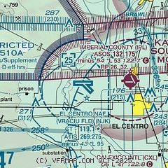
| Sectional chart |
|---|
|
 Download PDF
of official airport diagram from the FAA
| Airport distance calculator |
|---|
|
|
| Sunrise and sunset |
|---|
|
Times for 06-Mar-2025
| | Local
(UTC-8) | | Zulu
(UTC) |
|---|
| Morning civil twilight | | 05:41 | | 13:41 |
| Sunrise | | 06:05 | | 14:05 |
| Sunset | | 17:43 | | 01:43 |
| Evening civil twilight | | 18:07 | | 02:07 |
|
| Current date and time |
|---|
| Zulu (UTC) | 06-Mar-2025 22:13:19 |
|---|
| Local (UTC-8) | 06-Mar-2025 14:13:19 |
|---|
|
| METAR |
|---|
| KNJK | 062156Z 24026G35KT 10SM SCT075 20/03 A2985 RMK AO2 PK WND 25040/2125 SLP123 T02000033 $
|
KIPL
4nm E | 062153Z AUTO 26024G39KT 10SM CLR 19/04 A2981 RMK AO2 PK WND 25040/2124 SLP095 T01940044
|
|
| TAF |
|---|
| KNJK | 0615/0715 26022G32KT 9999 FEW075 530009 QNH2979INS TEMPO 0616/0622 26028G40KT BECMG 0703/0704 27015G25KT 9999 VCSH BKN050 BKN080 610558 520009 QNH2981INS TEMPO 0706/0709 30012G25KT -SHRA FM071000 30012KT 9999 FEW060 FEW100 600000 520009 QNH2985INS TX19/0623Z TN10/0714Z FS30130
|
KIPL
4nm E | 061720Z 0618/0718 25023G34KT P6SM FEW070 FM070200 27011G22KT P6SM FEW050 SCT080 FM070600 28009KT P6SM VCSH BKN050 OVC070 TEMPO 0706/0709 35010KT 5SM -SHRA BR SCT020 OVC040 FM071100 29008KT P6SM FEW050 SCT150
|
|
| NOTAMs |
|---|
NOTAMs are issued by the DoD/FAA and will open in a separate window not controlled by AirNav.
|
|


