FAA INFORMATION EFFECTIVE 17 APRIL 2025
Location
| FAA Identifier: | OFK |
| Lat/Long: | 41-59-07.6570N 097-26-06.4100W
41-59.127617N 097-26.106833W
41.9854603,-97.4351139
(estimated) |
| Elevation: | 1572.6 ft. / 479.3 m (surveyed) |
| Variation: | 05E (2005) |
| From city: | 3 miles SW of NORFOLK, NE |
| Time zone: | UTC -5 (UTC -6 during Standard Time) |
| Zip code: | 68701 |
Airport Operations
| Airport use: | Open to the public |
| Activation date: | 04/1940 |
| Control tower: | no |
| ARTCC: | MINNEAPOLIS CENTER |
| FSS: | COLUMBUS FLIGHT SERVICE STATION |
| NOTAMs facility: | OFK (NOTAM-D service available) |
| Attendance: | SAT 0700-1700, ALL SUN 1000-1700, ALL M-F 0700-1900
FOR SVC AFT HRS CALL AMGR OR 402-992-7914. |
| Wind indicator: | lighted |
| Segmented circle: | yes |
| Lights: | ACTVT MALSR RWY 02; REIL RWYS 20 & 32; PAPI RWYS 02, 20, 14, & 32; HIRL RWY 02/20; MIRL RWY 14/32 - CTAF. |
| Beacon: | white-green (lighted land airport)
Operates sunset to sunrise. |
Airport Communications
| CTAF/UNICOM: | 122.7 |
| WX ASOS: | 119.025 (402-644-4480) |
- APCH/DEP SVC PRVDD BY MINNEAPOLIS ARTCC (ZMP) ON FREQ 125.025/235.625(SIOUX CITY RCAG).
Nearby radio navigation aids
| VOR radial/distance | | VOR name | | Freq | | Var |
|---|
| OFK at field | | NORFOLK VOR/DME | | 114.35 | | 08E |
| OLUr345/32.4 | | COLUMBUS VOR/DME | | 116.95 | | 08E |
| NDB name | | Hdg/Dist | | Freq | | Var | | ID |
|---|
| PLATTE CENTER | | 347/29.4 | | 407 | | 08E | | PLT | .--. .-.. - |
Airport Services
| Fuel available: | 100LL JET-A
100LL:SELF SVC FUEL AVBL H24 100LL ONLY. |
| Parking: | hangars and tiedowns |
| Airframe service: | MAJOR |
| Powerplant service: | MAJOR |
| Bottled oxygen: | NONE |
| Bulk oxygen: | NONE |
Runway Information
Runway 14/32
| Dimensions: | 5806 x 100 ft. / 1770 x 30 m |
| Surface: | asphalt/porous friction courses, in good condition |
| Weight bearing capacity: | | Single wheel: | 75.0 | | Double wheel: | 192.0 | | Double tandem: | 400.0 |
|
| Runway edge lights: | medium intensity |
| RUNWAY 14 | | RUNWAY 32 |
| Latitude: | 41-59.524708N | | 41-58.772145N |
| Longitude: | 097-26.571005W | | 097-25.780943W |
| Elevation: | 1542.8 ft. | | 1564.1 ft. |
| Traffic pattern: | left | | left |
| Runway heading: | 137 magnetic, 142 true | | 317 magnetic, 322 true |
| Displaced threshold: | 287 ft. | | 360 ft. |
| Declared distances: | TORA:5443 TODA:5800 ASDA:5443 LDA:5160 | | TORA:5517 TODA:5800 ASDA:5517 LDA:5160 |
| Markings: | nonprecision, in good condition | | nonprecision, in good condition |
| Visual slope indicator: | 4-light PAPI on left (3.00 degrees glide path) | | 4-light PAPI on left (3.50 degrees glide path) |
| Runway end identifier lights: | | | yes |
| Touchdown point: | yes, no lights | | yes, no lights |
| Obstructions: | 28 ft. rr, 952 ft. from runway, 364 ft. right of centerline, 26:1 slope to clear
CNTRLN SLP TO DTHR 39:1 DUE TO 86 FT TREE 3424 FT FM DTHR 50 FT R. | | 41 ft. tree, 1069 ft. from runway, 359 ft. right of centerline, 21:1 slope to clear
CNTRLN SLP TO DTHR 34:1 DUE TO 41 FT TREE 1429 FT FM DTHR 359 FT R. |
Runway 2/20
| Dimensions: | 5801 x 100 ft. / 1768 x 30 m |
| Surface: | asphalt/porous friction courses, in good condition |
| Weight bearing capacity: | | Single wheel: | 60.0 | | Double wheel: | 192.0 | | Double tandem: | 360.0 |
|
| Runway edge lights: | high intensity |
| RUNWAY 2 | | RUNWAY 20 |
| Latitude: | 41-58.656482N | | 41-59.557068N |
| Longitude: | 097-26.250228W | | 097-25.825013W |
| Elevation: | 1572.6 ft. | | 1530.5 ft. |
| Traffic pattern: | left | | left |
| Runway heading: | 014 magnetic, 019 true | | 194 magnetic, 199 true |
| Displaced threshold: | no | | 297 ft. |
| Markings: | precision, in good condition | | nonprecision, in good condition |
| Visual slope indicator: | 4-light PAPI on left (3.00 degrees glide path) | | 4-light PAPI on left (3.00 degrees glide path) |
| Approach lights: | MALSR: 1,400 foot medium intensity approach lighting system with runway alignment indicator lights | | |
| Runway end identifier lights: | | | yes |
| Touchdown point: | yes, no lights | | yes, no lights |
| Instrument approach: | ILS | | |
| Obstructions: | 27 ft. fence, 1182 ft. from runway, 647 ft. right of centerline, 36:1 slope to clear | | 69 ft. tree, 1428 ft. from runway, 583 ft. right of centerline, 17:1 slope to clear |
Airport Ownership and Management from official FAA records
| Ownership: | Publicly-owned |
| Owner: | NORFOLK AIRPORT AUTHORITY
P.O. BOX 1343
NORFOLK, NE 68702-1343
Phone 402-841-5130 |
| Manager: | MR CARL BARROWS
P.O. BOX 1343
NORFOLK, NE 68702-1343
Phone 402-841-5130 |
Additional Remarks
| - | RWY 20 DSGND AS CALM WIND RWY. ALL RWYS HAVE L HAND TFC ONLY. |
| - | FOR CD IF UNA TO CTC ON FSS FREQ, CTC MINNEAPOLIS ARTCC AT 651-463-5588. |
Instrument Procedures
NOTE: All procedures below are presented as PDF files. If you need a reader for these files, you should download the free Adobe Reader.NOT FOR NAVIGATION. Please procure official charts for flight.
FAA instrument procedures published for use from 17 April 2025 at 0901Z to 15 May 2025 at 0900z.
IAPs - Instrument Approach Procedures |
|---|
| ILS OR LOC RWY 02 | |
download (282KB) |
| RNAV (GPS) RWY 02 | |
download (219KB) |
| RNAV (GPS) RWY 14 | |
download (223KB) |
| RNAV (GPS) RWY 20 | |
download (209KB) |
| RNAV (GPS) RWY 32 | |
download (227KB) |
| VOR RWY 14 | |
download (205KB) |
| VOR RWY 32 | |
download (196KB) |
| NOTE: Special Alternate Minimums apply | |
download (149KB) |
| NOTE: Special Take-Off Minimums/Departure Procedures apply | |
download (360KB) |
Other nearby airports with instrument procedures:
KLCG - Wayne Municipal Airport/Stan Morris Field (25 nm NE)
4V9 - Antelope County Airport (28 nm W)
KBVN - Albion Municipal Airport (32 nm SW)
0C4 - Pender Municipal Airport (32 nm E)
KOLU - Columbus Municipal Airport (32 nm S)
|
|

Road maps at:
MapQuest
Bing
Google
| Aerial photo |
|---|
WARNING: Photo may not be current or correct

Do you have a better or more recent aerial photo of Norfolk Regional Airport/Karl Stefan Memorial Field that you would like to share? If so, please send us your photo.
|
| Sectional chart |
|---|
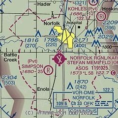
|
 Download PDF
of official airport diagram from the FAA
| Airport distance calculator |
|---|
|
|
| Sunrise and sunset |
|---|
|
Times for 26-Apr-2025
| | Local
(UTC-5) | | Zulu
(UTC) |
|---|
| Morning civil twilight | | 06:04 | | 11:04 |
| Sunrise | | 06:34 | | 11:34 |
| Sunset | | 20:22 | | 01:22 |
| Evening civil twilight | | 20:52 | | 01:52 |
|
| Current date and time |
|---|
| Zulu (UTC) | 27-Apr-2025 00:54:10 |
|---|
| Local (UTC-5) | 26-Apr-2025 19:54:10 |
|---|
|
| METAR |
|---|
| KOFK | 262356Z AUTO 13011KT 10SM OVC055 14/07 A3010 RMK AO2 SLP194 60000 T01440072 10150 20122 56022
|
|
| TAF |
|---|
| KOFK | 262009Z 2620/2718 13012KT P6SM -SHRA OVC090 FM262300 13012KT P6SM OVC060 FM270400 15013KT P6SM OVC020 FM271000 16012KT P6SM OVC015 FM271200 16013G22KT P6SM OVC008
|
|
| NOTAMs |
|---|
NOTAMs are issued by the DoD/FAA and will open in a separate window not controlled by AirNav.
|
|


