FAA INFORMATION EFFECTIVE 17 APRIL 2025
Location
| FAA Identifier: | OOA |
| Lat/Long: | 41-13-34.0000N 092-29-37.8000W
41-13.566667N 092-29.630000W
41.2261111,-92.4938333
(estimated) |
| Elevation: | 840.2 ft. / 256.1 m (surveyed) |
| Variation: | 01E (2010) |
| From city: | 9 miles SE of OSKALOOSA, IA |
| Time zone: | UTC -5 (UTC -6 during Standard Time) |
| Zip code: | 52543 |
Airport Operations
| Airport use: | Open to the public |
| Activation date: | 10/1959 |
| Control tower: | no |
| ARTCC: | CHICAGO CENTER |
| FSS: | FORT DODGE FLIGHT SERVICE STATION |
| NOTAMs facility: | OOA (NOTAM-D service available) |
| Attendance: | MAY-SEP MON - FRI 0800-1800, OCT-APR MON - FRI 0800-1700, ALL SAT - SUN ON CALL
641-933-4316 |
| Wind indicator: | lighted |
| Segmented circle: | no |
| Lights: | ACTVT MIRL RWY 13/31; REIL RWY 13/31 - CTAF. |
| Beacon: | white-green (lighted land airport)
Operates sunset to sunrise. |
Airport Communications
| CTAF/UNICOM: | 122.8 |
| WX AWOS-3: | 118.625 (641-933-4312) |
| WX ASOS at OTM (7 nm S): | 124.175 (641-684-9164) |
- APCH/DEP SVC PRVDD BY CHICAGO ARTCC ON FREQS 118.15/335.575 (OTTUMWA RCAG).
Airport Services
| Fuel available: | 100LL JET-A |
| Parking: | hangars and tiedowns |
| Airframe service: | MAJOR |
| Powerplant service: | MAJOR |
| Bottled oxygen: | NONE |
| Bulk oxygen: | NONE |
Runway Information
Runway 13/31
| Dimensions: | 4012 x 75 ft. / 1223 x 23 m |
| Surface: | concrete, in good condition |
| Weight bearing capacity: | | PCN 8 /R/C/W/T | | Single wheel: | 25.0 |
|
| Runway edge lights: | medium intensity |
| RUNWAY 13 | | RUNWAY 31 |
| Latitude: | 41-13.723202N | | 41-13.259618N |
| Longitude: | 092-29.940385W | | 092-29.316870W |
| Elevation: | 837.3 ft. | | 835.7 ft. |
| Traffic pattern: | left | | left |
| Runway heading: | 134 magnetic, 135 true | | 314 magnetic, 315 true |
| Markings: | nonprecision, in good condition | | nonprecision, in good condition |
| Visual slope indicator: | 2-light PAPI on left (3.00 degrees glide path) | | 2-light PAPI on left (3.00 degrees glide path) |
| Runway end identifier lights: | yes | | yes |
| Touchdown point: | yes, no lights | | yes, no lights |
Runway 4/22
| Dimensions: | 1926 x 75 ft. / 587 x 23 m |
| Surface: | concrete, in fair condition |
| Weight bearing capacity: | | PCN 6 /R/D/W/U | | Single wheel: | 25.0 |
|
| RUNWAY 4 | | RUNWAY 22 |
| Latitude: | 41-13.612008N | | 41-13.837932N |
| Longitude: | 092-29.779143W | | 092-29.484402W |
| Elevation: | 837.5 ft. | | 839.8 ft. |
| Traffic pattern: | left | | left |
| Runway heading: | 044 magnetic, 045 true | | 224 magnetic, 225 true |
| Markings: | nonprecision, in fair condition | | nonprecision, in fair condition |
| Touchdown point: | yes, no lights | | yes, no lights |
Airport Ownership and Management from official FAA records
| Ownership: | Publicly-owned |
| Owner: | CITY OF OSKALOOSA
220 SOUTH MARKET
OSKALOOSA, IA 52577
Phone 641-673-9431 |
| Manager: | SHANE VANDE VOORT
2973 URBANA AVENUE
OSKALOOSA, IA 52577
Phone 641-933-4316 |
Additional Remarks
| - | FOR CD CTC CHICAGO ARTCC AT 630-906-8921. |
Instrument Procedures
NOTE: All procedures below are presented as PDF files. If you need a reader for these files, you should download the free Adobe Reader.NOT FOR NAVIGATION. Please procure official charts for flight.
FAA instrument procedures published for use from 17 April 2025 at 0901Z to 15 May 2025 at 0900z.
IAPs - Instrument Approach Procedures |
|---|
| RNAV (GPS) RWY 13 | |
download (239KB) |
| RNAV (GPS) RWY 31 | |
download (242KB) |
| NOTE: Special Alternate Minimums apply | |
download (24KB) |
| NOTE: Special Take-Off Minimums/Departure Procedures apply | |
download (158KB) |
Other nearby airports with instrument procedures:
KOTM - Ottumwa Regional Airport (7 nm S)
4C8 - Albia Municipal Airport (18 nm SW)
KPEA - Pella Municipal Airport (23 nm NW)
KFFL - Fairfield Municipal Airport (25 nm SE)
KOXV - Knoxville Municipal Airport (28 nm W)
|
|

Road maps at:
MapQuest
Bing
Google
| Aerial photo |
|---|
WARNING: Photo may not be current or correct
 Photo taken 09-Oct-2008
Do you have a better or more recent aerial photo of Oskaloosa Municipal Airport that you would like to share? If so, please send us your photo.
|
| Sectional chart |
|---|
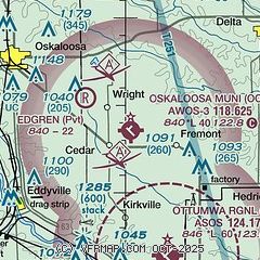
|
| Airport distance calculator |
|---|
|
|
| Sunrise and sunset |
|---|
|
Times for 26-Apr-2025
| | Local
(UTC-5) | | Zulu
(UTC) |
|---|
| Morning civil twilight | | 05:46 | | 10:46 |
| Sunrise | | 06:15 | | 11:15 |
| Sunset | | 20:00 | | 01:00 |
| Evening civil twilight | | 20:30 | | 01:30 |
|
| Current date and time |
|---|
| Zulu (UTC) | 26-Apr-2025 17:41:16 |
|---|
| Local (UTC-5) | 26-Apr-2025 12:41:16 |
|---|
|
| METAR |
|---|
| KOOA | 261715Z AUTO 11008KT 060V120 10SM CLR 15/06 A3030 RMK AO2 T01530056
|
KOTM
8nm S | 261653Z AUTO 09010G17KT 10SM CLR 13/06 A3030 RMK AO2 SLP260 T01330056
|
|
| TAF |
|---|
KOTM
8nm S | 261134Z 2612/2712 04009KT P6SM FEW200 FM261600 06010KT P6SM SCT120 FM262200 10009KT P6SM SCT120
|
|
| NOTAMs |
|---|
NOTAMs are issued by the DoD/FAA and will open in a separate window not controlled by AirNav.
|
|


