FAA INFORMATION EFFECTIVE 20 FEBRUARY 2025
Location
| FAA Identifier: | PAH |
| Lat/Long: | 37-03-37.0380N 088-46-22.6530W
37-03.617300N 088-46.377550W
37.0602883,-88.7729592
(estimated) |
| Elevation: | 410.9 ft. / 125.2 m (surveyed) |
| Variation: | 01W (2005) |
| From city: | 12 miles W of PADUCAH, KY |
| Time zone: | UTC -6 (UTC -5 during Daylight Saving Time) |
| Zip code: | 42086 |
Airport Operations
| Airport use: | Open to the public |
| Activation date: | 01/1943 |
| Control tower: | yes |
| ARTCC: | MEMPHIS CENTER |
| FSS: | LOUISVILLE FLIGHT SERVICE STATION |
| NOTAMs facility: | PAH (NOTAM-D service available) |
| Attendance: | 0500-1800 |
| Wind indicator: | lighted |
| Segmented circle: | yes |
| Lights: | WHEN ATCT CLSD ACTVT MALSR RWY 05; REIL RWY 23 & 32; PAPI RWY 23 &32; HIRL RWY 05/23; MIRL RWY 14/32; TWY LGTS; LGTD WIND CONE - CTAF. |
| Beacon: | white-green (lighted land airport)
Operates sunset to sunrise. |
| Fire and rescue: | ARFF index A |
| Airline operations: | ACR OPS WITH MORE THAN 30 PAX SEATS 24 HR PPR - 270-744-0521. |
Airport Communications
| CTAF: | 119.6 |
| UNICOM: | 122.95 |
| WX ASOS: | 118.375 (270-744-6719) |
| PADUCAH GROUND: | 121.7 306.9 [0600-2300] |
| PADUCAH TOWER: | 119.6 306.9 [0600-2300] |
| WX AWOS-3 at M30 (7 nm N): | 124.175 (618-524-7483) |
| WX AWOS-3 at M25 (20 nm SE): | 120.625 (270-247-2094) |
- ATCT LEASED TO CITY OPERATED BY ARPT COMMISSION.
- APCH/DEP SVC PRVDD BY MEMPHIS ARTCC ON FREQS 133.65/292.15 (PADUCAH RCAG).
Nearby radio navigation aids
| VOR radial/distance | | VOR name | | Freq | | Var |
|---|
| CNGr042/4.4 | | CUNNINGHAM VOR/DME | | 113.10 | | 03E |
| NDB name | | Hdg/Dist | | Freq | | Var | | ID |
|---|
| CAIRO | | 090/21.6 | | 397 | | 00E | | CIR | -.-. .. .-. |
Airport Services
| Fuel available: | 100LL JET-A |
| Parking: | hangars and tiedowns |
| Airframe service: | MAJOR |
| Powerplant service: | MAJOR |
| Bottled oxygen: | HIGH |
Runway Information
Runway 5/23
| Dimensions: | 6500 x 150 ft. / 1981 x 46 m |
| Surface: | asphalt/grooved, in good condition |
| Weight bearing capacity: | | PCN 66 /F/C/X/T | | Single wheel: | 76.0 | | Double wheel: | 99.0 | | Double tandem: | 170.0 |
|
| Runway edge lights: | high intensity |
| Operational restrictions: | ACFT OPS NOT VSB FM OPPOSITE RWY ENDS DUE TO GRADE. |
| RUNWAY 5 | | RUNWAY 23 |
| Latitude: | 37-03.208713N | | 37-03.983188N |
| Longitude: | 088-46.888822W | | 088-45.965467W |
| Elevation: | 410.6 ft. | | 381.4 ft. |
| Traffic pattern: | left | | left |
| Runway heading: | 045 magnetic, 044 true | | 225 magnetic, 224 true |
| Declared distances: | TORA:6500 TODA:6500 ASDA:6500 LDA:6500 | | TORA:6500 TODA:6500 ASDA:6500 LDA:6500 |
| Markings: | precision, in good condition | | precision, in good condition |
| Visual slope indicator: | | | 4-light PAPI on left (3.00 degrees glide path) |
| Approach lights: | MALSR: 1,400 foot medium intensity approach lighting system with runway alignment indicator lights | | |
| Runway end identifier lights: | | | yes |
| Touchdown point: | yes, no lights | | yes, no lights |
| Instrument approach: | ILS | | |
| Obstructions: | 37 ft. pole, 1600 ft. from runway, 312 ft. right of centerline, 37:1 slope to clear | | 28 ft. trees, 1000 ft. from runway, 500 ft. left of centerline, 28:1 slope to clear |
Runway 14/32
| Dimensions: | 5499 x 150 ft. / 1676 x 46 m |
| Surface: | asphalt/grooved, in good condition |
| Weight bearing capacity: | | PCN 52 /F/B/X/T | | Single wheel: | 75.0 | | Double wheel: | 100.0 | | Double tandem: | 170.0 |
|
| Runway edge lights: | medium intensity |
| RUNWAY 14 | | RUNWAY 32 |
| Latitude: | 37-03.986680N | | 37-03.298308N |
| Longitude: | 088-46.686512W | | 088-45.951267W |
| Elevation: | 392.3 ft. | | 409.5 ft. |
| Traffic pattern: | left | | left |
| Runway heading: | 140 magnetic, 139 true | | 320 magnetic, 319 true |
| Displaced threshold: | 100 ft. | | no |
| Declared distances: | TORA:5499 TODA:5499 ASDA:5499 LDA:5399 | | TORA:5499 TODA:5499 ASDA:5324 LDA:5324 |
| Markings: | nonprecision, in good condition | | nonprecision, in good condition |
| Visual slope indicator: | | | 4-light PAPI on left (3.00 degrees glide path) |
| Runway end identifier lights: | | | yes |
| Touchdown point: | yes, no lights | | yes, no lights |
| Obstructions: | 26 ft. tree, 900 ft. from runway, 200 ft. left of centerline, 26:1 slope to clear | | 71 ft. trees, 1175 ft. from runway, 390 ft. right of centerline, 13:1 slope to clear |
Airport Ownership and Management from official FAA records
| Ownership: | Publicly-owned |
| Owner: | BARKLEY REGIONAL AIRPORT AUTHORITY
100 TERMINAL DRIVE
WEST PADUCAH, KY 42086-1131
Phone 270-744-0521 |
| Manager: | DENNIS ROULEAU
100 TERMINAL DRIVE
WEST PADUCAH, KY 42086-1131
Phone 270-744-0521 |
Additional Remarks
| - | NWS ON ARPT - 270-744-6440. |
| - | SFC COND NOT MNTD 0001-0500; WET SFC COND NOT RPRTD. |
| - | FOR CD CTC MEMPHIS ARTCC AT 901-368-8453/8449. |
Instrument Procedures
NOTE: All procedures below are presented as PDF files. If you need a reader for these files, you should download the free Adobe Reader.NOT FOR NAVIGATION. Please procure official charts for flight.
FAA instrument procedures published for use from 20 February 2025 at 0901Z to 20 March 2025 at 0900Z.
IAPs - Instrument Approach Procedures |
|---|
| ILS OR LOC RWY 05 | |
download (244KB) |
| RNAV (GPS) RWY 05 | |
download (234KB) |
| RNAV (GPS) RWY 14 | |
download (238KB) |
| RNAV (GPS) RWY 23 | |
download (249KB) |
| RNAV (GPS) RWY 32 | |
download (247KB) |
| VOR RWY 23 | |
download (249KB) |
| VOR RWY 05 | |
download (229KB) |
| NOTE: Special Alternate Minimums apply | |
download (146KB) |
| NOTE: Special Take-Off Minimums/Departure Procedures apply | |
download (363KB) |
Other nearby airports with instrument procedures:
M25 - Mayfield Graves County Airport (20 nm SE)
KCIR - Cairo Regional Airport (21 nm W)
M34 - Kentucky Dam State Park Airport (23 nm E)
KCEY - Kyle-Oakley Field Airport (31 nm SE)
KCHQ - Mississippi County Airport (31 nm SW)
|
|

Road maps at:
MapQuest
Bing
Google
| Aerial photo |
|---|
WARNING: Photo may not be current or correct
 Photo by George Cumbee
Photo taken 08-Jul-2015
looking west.
Photo by George Cumbee
Photo taken 08-Jul-2015
looking west.
Do you have a better or more recent aerial photo of Barkley Regional Airport that you would like to share? If so, please send us your photo.
|
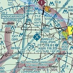
| Sectional chart |
|---|
|
 Download PDF
of official airport diagram from the FAA
| Airport distance calculator |
|---|
|
|
| Sunrise and sunset |
|---|
|
Times for 12-Mar-2025
| | Local
(UTC-6) | | Zulu
(UTC) |
|---|
| Morning civil twilight | | 05:46 | | 11:46 |
| Sunrise | | 06:12 | | 12:12 |
| Sunset | | 17:58 | | 23:58 |
| Evening civil twilight | | 18:24 | | 00:24 |
|
| Current date and time |
|---|
| Zulu (UTC) | 12-Mar-2025 06:51:04 |
|---|
| Local (UTC-6) | 12-Mar-2025 00:51:04 |
|---|
|
| METAR |
|---|
| KPAH | 120553Z AUTO 21007KT 180V250 10SM CLR 17/05 A2979 RMK AO2 SLP084 T01720050 10233 20172 402560050 52002
|
KM30
8nm N | 120635Z AUTO 20004KT 10SM CLR 15/05 A2981 RMK AO2 T01480045
|
KM25
20nm SE | 120635Z AUTO 21010KT 10SM CLR 16/05 A2982 RMK AO2 T01650048
|
|
| TAF |
|---|
| KPAH | 120520Z 1206/1306 21006KT P6SM SKC WS020/24040KT FM120900 20006KT P6SM FEW250 FM121700 21011G17KT P6SM SCT250 FM122300 20006KT P6SM SCT060 BKN250 FM130300 19005KT P6SM BKN060
|
|
| NOTAMs |
|---|
NOTAMs are issued by the DoD/FAA and will open in a separate window not controlled by AirNav.
|
|


