FAA INFORMATION EFFECTIVE 17 APRIL 2025
Location
| FAA Identifier: | PNS |
| Lat/Long: | 30-28-24.3000N 087-11-11.8000W
30-28.405000N 087-11.196667W
30.4734167,-87.1866111
(estimated) |
| Elevation: | 120.9 ft. / 36.9 m (surveyed) |
| Variation: | 02W (2010) |
| From city: | 3 miles NE of PENSACOLA, FL |
| Time zone: | UTC -5 (UTC -6 during Standard Time) |
| Zip code: | 32504 |
Airport Operations
| Airport use: | Open to the public |
| Control tower: | yes |
| ARTCC: | JACKSONVILLE CENTER |
| FSS: | GAINESVILLE FLIGHT SERVICE STATION |
| NOTAMs facility: | PNS (NOTAM-D service available) |
| Attendance: | CONTINUOUS |
| Pattern altitude: | OVHD 1500 FT. |
| Wind indicator: | lighted |
| Segmented circle: | yes |
| Lights: | WHEN ATCT CLSD, ACTVT MALSR RWY 17; TDZ RWY 17; HIRL RWY 17/35, 08/26 - CTAF. |
| Beacon: | white-green (lighted land airport)
Operates sunset to sunrise. |
| Fire and rescue: | ARFF index C |
| Airline operations: | PPR 24HRS IN ADVN FOR UNSKED AIR CARRIER OPS WITH MORE THAN 30 PAX SEATS OR FOR ANY UNSKED ACFT EXCEEDING 65,000LBS GWT AND/OR WINGSPAN GREATER THAN 79 FT, ANY TILT-ROTOR ACFT AND/OR HELS WITH A ROTOR DIAMETER GREATER THAN 79 FT CALL (850) 436-5000. |
| International operations: | customs landing rights airport
FLT NTFN SVC (ADCUS) AVBL. |
Airport Communications
| CTAF: | 119.9 |
| UNICOM: | 122.95 |
| ATIS: | 121.25 |
| WX ASOS: | 121.25 (850-436-4799) |
| PENSACOLA GROUND: | 121.9 348.6 [0530-2300] |
| PENSACOLA TOWER: | 119.9 257.8 [0530-2300] |
| PENSACOLA APPROACH: | 360.725 118.6 ;251-339 119.0 ;340-159 124.05 132.1 |
| PENSACOLA DEPARTURE: | 360.725 118.6 ;251-339 119.0 ;340-159 125.35 124.05 132.1 |
| CLEARANCE DELIVERY: | 123.725 256.875 348.6 348.6 |
| PRE-TAXI CLEARANCE: | 348.6 |
| CLASS C: | 118.6 ;251-339 119.0 ;340-159 120.65 ;160-250 |
| EMERG: | 121.5 243.0 |
| IC: | 119.0 ;340-159 |
| WX ASOS at NDZ (16 nm NE): | PHONE 850-623-7210 |
| WX ASOS at NSE (17 nm NE): | PHONE 850-623-7241 |
- TA35 LLWAS UNMON 2300-0530.
Nearby radio navigation aids
| VOR radial/distance | | VOR name | | Freq | | Var |
|---|
| NUNr088/(7.7) | | SAUFLEY VOR | | 112.25 | | 01E |
| CEWr228/33.7 | | CRESTVIEW VORTAC | | 115.90 | | 03E |
Airport Services
| Fuel available: | 100 100LL JET-A |
| Parking: | hangars and tiedowns |
| Airframe service: | MAJOR |
| Powerplant service: | MAJOR |
| Bottled oxygen: | NONE |
| Bulk oxygen: | HIGH |
Runway Information
Runway 17/35
| Dimensions: | 7004 x 150 ft. / 2135 x 46 m |
| Surface: | concrete/grooved, in good condition |
| Weight bearing capacity: | | Single wheel: | 120.0 | | Double wheel: | 250.0 | | Double tandem: | 550.0 | | Dual double tandem: | 1058.0 |
|
| Runway edge lights: | high intensity |
| RUNWAY 17 | | RUNWAY 35 |
| Latitude: | 30-28.974538N | | 30-27.848855N |
| Longitude: | 087-11.439362W | | 087-11.139113W |
| Elevation: | 120.9 ft. | | 102.7 ft. |
| Traffic pattern: | left | | left |
| Runway heading: | 169 magnetic, 167 true | | 349 magnetic, 347 true |
| Markings: | precision, in good condition | | precision, in good condition |
| Visual slope indicator: | 4-light PAPI on left (3.00 degrees glide path) | | 4-light PAPI on left (3.00 degrees glide path) |
| RVR equipment: | touchdown | | touchdown |
| Approach lights: | MALSR: 1,400 foot medium intensity approach lighting system with runway alignment indicator lights | | |
| Runway end identifier lights: | | | yes |
| Centerline lights: | yes | | yes |
| Touchdown point: | yes, lighted | | yes, no lights |
| Instrument approach: | ILS/DME | | |
| Obstructions: | 86 ft. pline, 4390 ft. from runway, 500 ft. left of centerline, 48:1 slope to clear
4275 FT TWR 900 FT L EL 204. | | none |
Runway 8/26
| Dimensions: | 7000 x 150 ft. / 2134 x 46 m |
| Surface: | asphalt/grooved, in fair condition |
| Weight bearing capacity: | | Single wheel: | 120.0 | | Double wheel: | 250.0 | | Double tandem: | 550.0 | | Dual double tandem: | 1120.0, FDOT AVN OFC STATEWIDE PCR DVLPMT PROGRAM SEPTEMBER 2024. |
|
| Runway edge lights: | high intensity |
| RUNWAY 8 | | RUNWAY 26 |
| Latitude: | 30-28.280053N | | 30-28.518790N |
| Longitude: | 087-11.756288W | | 087-10.451995W |
| Elevation: | 97.1 ft. | | 113.4 ft. |
| Traffic pattern: | left | | left |
| Runway heading: | 080 magnetic, 078 true | | 260 magnetic, 258 true |
| Markings: | precision, in fair condition | | precision, in fair condition |
| Visual slope indicator: | 4-light PAPI on left (3.00 degrees glide path) | | 4-light PAPI on left (3.00 degrees glide path) |
| Runway end identifier lights: | yes | | yes |
| Touchdown point: | yes, no lights | | yes, no lights |
| Instrument approach: | | | LOC/DME |
| Obstructions: | 29 ft. trees, 1365 ft. from runway, 410 ft. right of centerline, 40:1 slope to clear
405 FT TREES R OF CNTRLN 200 FT BFR AER. | | 43 ft. trees, 1690 ft. from runway, 355 ft. left of centerline, 34:1 slope to clear |
Airport Ownership and Management from official FAA records
| Ownership: | Publicly-owned |
| Owner: | CITY OF PENSACOLA
2430 AIRPORT BLVD SUITE 225
PENSACOLA, FL 32504
Phone 850-436-5000 |
| Manager: | MATT COUGHLIN, C.M.
2430 AIRPORT BLVD SUITE 225
PENSACOLA, FL 32504
Phone 850-436-5000 |
Additional Remarks
| A39-17/35 | PCR VALUE: 930/R/B/W/T |
| A39-08/26 | PCR VALUE: 780/F/A/X/T |
| A30A-08 | PREFERRED DEP RWY. |
| A30A-26 | BLACK HOLE ILLUSION EXISTS DURG NGT APCH. |
| - | BIRDS ON & INVOF ARPT. |
| - | TWY C SOUTH OF RWY 8/26, C1, C2, TWY D EAST OF RWY 17/35, D1, D2, D3, D4, & D5 ARE 35 FT WIDE; CLSD TO ACFT WITH A WINGSPAN MORE THAN 79 FT. |
| - | RUN-UP PAD FOR PISTON ACFT LCTD ON TWY D BTWN D1 & C; FACE NOSE OF ACFT S; OTR ACFT RUN-UP INFO - AMGR. |
| - | CTN: RWY 08 APCHS MAY MISTAKE SAUFLEY FIELD NOLF LCTD 7 MI W FOR PNS. |
| - | FOR CD IF UNA TO CTC ON FSS FREQ, CTC PENSACOLA APCH AT 850-266-6884 OR 850-266-6885. |
| - | NEW APRON SOUTH OF U.S. CUSTOMS AND BORDER PROTECTION (CBP) TEMPORARILY CLSD EXC FOR ACFT BEING PROCESSED BY CBP. |
| - | TBJT WITH MAX TKOF WT OVR 75000 LBS EXCT STD NOISE ABATEMENT DEP PROFILE IAW FAA AC 91-53. |
| - | FIXED WING VFR DEP PROCD TO ARPT BDRY BFR TURNING UNLESS DRCTD BY ATC. |
| - | HEL LNDG - PENSACOLA AVIATION 850-434-0636; HEL PRKG LCTD S OF GEN AVN PRKG RAMP BTW TWY C1 & C2 ON CONC PADS. |
Instrument Procedures
NOTE: All procedures below are presented as PDF files. If you need a reader for these files, you should download the free Adobe Reader.NOT FOR NAVIGATION. Please procure official charts for flight.
FAA instrument procedures published for use from 17 April 2025 at 0901Z to 15 May 2025 at 0900z.
IAPs - Instrument Approach Procedures |
|---|
| ILS OR LOC RWY 17 **CHANGED** | |
download (311KB) |
| RNAV (GPS) RWY 08 **CHANGED** | |
download (279KB) |
| RNAV (GPS) RWY 17 **CHANGED** | |
download (252KB) |
| RNAV (GPS) RWY 26 **CHANGED** | |
download (254KB) |
| RNAV (GPS) RWY 35 **CHANGED** | |
download (276KB) |
| LOC RWY 26 **CHANGED** | |
download (265KB) |
| VOR RWY 08 **CHANGED** | |
download (227KB) |
| NOTE: Special Alternate Minimums apply | |
download (124KB) |
| NOTE: Special Take-Off Minimums/Departure Procedures apply | |
download (212KB) |
Other nearby airports with instrument procedures:
KNPA - Pensacola Naval Air Station (Forrest Sherman Field) Airport (10 nm SW)
2R4 - Peter Prince Field Airport (14 nm NE)
KNDZ - Whiting Field Naval Air Station South (16 nm NE)
KNSE - Whiting Field Naval Air Station North (17 nm NE)
KHRT - Hurlburt Field Airport (26 nm E)
|
|

Road maps at:
MapQuest
Bing
Google
| Aerial photo |
|---|
WARNING: Photo may not be current or correct
 Photo courtesy of AirNav, LLC
Photo taken 05-May-2011
looking southeast.
Photo courtesy of AirNav, LLC
Photo taken 05-May-2011
looking southeast.
Do you have a better or more recent aerial photo of Pensacola International Airport that you would like to share? If so, please send us your photo.
|
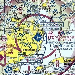
| Sectional chart |
|---|
|
CAUTION: Diagram may not be current
 Download PDF
of official airport diagram from the FAA
| Airport distance calculator |
|---|
|
|
| Sunrise and sunset |
|---|
|
Times for 21-Apr-2025
| | Local
(UTC-5) | | Zulu
(UTC) |
|---|
| Morning civil twilight | | 05:51 | | 10:51 |
| Sunrise | | 06:16 | | 11:16 |
| Sunset | | 19:19 | | 00:19 |
| Evening civil twilight | | 19:44 | | 00:44 |
|
| Current date and time |
|---|
| Zulu (UTC) | 21-Apr-2025 12:38:43 |
|---|
| Local (UTC-5) | 21-Apr-2025 07:38:43 |
|---|
|
| METAR |
|---|
| KPNS | 211153Z AUTO 00000KT 8SM BKN085 21/20 A3013 RMK AO2 SLP204 T02060200 10217 20200 53007
|
KNPA
10nm SW | 211156Z 10003KT 7SM MIFG BKN070 BKN250 20/19 A3013 RMK AO2 SLP203 T02000194 10222 20194 53006 $
|
KNDZ
16nm NE | 211156Z 07004KT 10SM BKN010 BKN090 BKN250 18/18 A3014 RMK AO2 SLP193 T01780178 10178 20167 53008 $
|
KNSE
17nm NE | 211158Z 09003KT 2 1/2SM BR BKN010 OVC090 17/17 A3014 RMK AO2 T01670167 $
|
|
| TAF |
|---|
| KPNS | 211138Z 2112/2212 15006KT P6SM FEW015 BKN080 FM211800 16009KT P6SM FEW030 BKN250 FM220700 15004KT 6SM BR OVC015 FM221000 14004KT 4SM BR OVC015
|
KNSE
17nm NE | 2107/2207 VRB06KT 3200 BR SCT030 SCT120 QNH3009INS TEMPO 2108/2114 0800 FG VV002 FM211500 17008KT 9999 SCT020 SCT180 QNH3009INS BECMG 2119/2121 19010G15KT 9999 FEW030 SCT180 QNH3005INS FM220100 VRB06KT 9999 FEW150 QNH3007INS TEMPO 2203/2207 4800 BR SCT009 SCT120 AUTOMATED SENSOR METWATCH 2107 TIL 2111 TX27/2118Z TN18/2110Z FN00286
|
|
| NOTAMs |
|---|
NOTAMs are issued by the DoD/FAA and will open in a separate window not controlled by AirNav.
|
|


