FAA INFORMATION EFFECTIVE 17 APRIL 2025
Location
| FAA Identifier: | RBO |
| Lat/Long: | 27-46-41.3000N 097-41-24.4000W
27-46.688333N 097-41.406667W
27.7781389,-97.6901111
(estimated) |
| Elevation: | 79.7 ft. / 24.3 m (surveyed) |
| Variation: | 06E (2000) |
| From city: | 2 miles SW of ROBSTOWN, TX |
| Time zone: | UTC -5 (UTC -6 during Standard Time) |
| Zip code: | 78380 |
Airport Operations
| Airport use: | Open to the public |
| Activation date: | 04/1947 |
| Control tower: | no |
| ARTCC: | HOUSTON CENTER |
| FSS: | SAN ANGELO FLIGHT SERVICE STATION |
| NOTAMs facility: | RBO (NOTAM-D service available) |
| Attendance: | MON-FRI 0800-1200, ALL MON-FRI 1300-1700 |
| Wind indicator: | lighted |
| Segmented circle: | yes |
| Lights: | MIRL RWY 13/31 PRESET LOW INTST; TO INCR INTST ACTVT - 122.8. |
| Beacon: | white-green (lighted land airport)
Operates sunset to sunrise. |
Airport Communications
| CTAF: | 122.9 |
| WX AWOS-3: | 118.175 (361-767-1982) |
| KINGSVILLE APPROACH: | 119.9 |
| KINGSVILLE DEPARTURE: | 120.9 |
| WX ASOS at CRP (10 nm E): | PHONE 361-267-5360 |
| WX AWOS-3 at T69 (17 nm NE): | 118.25 (361-364-1844) |
| WX ASOS at ALI (18 nm W): | 119.225 (361-668-0069) |
- APCH/DEP CTL SVC PRVDD BY HOUSTON ARTCC (ZHU) ON FREQS 128.15.350.3 (KINGSVILLE RCAG) WHEN KINGSVILLE APCH CTL (NQI) CLSD.
Nearby radio navigation aids
| VOR radial/distance | | VOR name | | Freq | | Var |
|---|
| CRPr231/15.0 | | CORPUS CHRISTI VORTAC | | 115.50 | | 09E |
| ALIr077/(17.7) | | ALICE VOR | | 114.50 | | 06E |
Airport Services
| Fuel available: | 100LL
100LL:FUEL AVBL 24 HRS. |
| Parking: | tiedowns |
| Airframe service: | MINOR |
| Powerplant service: | MINOR |
| Bottled oxygen: | NONE |
| Bulk oxygen: | NONE |
Runway Information
Runway 13/31
| Dimensions: | 3700 x 75 ft. / 1128 x 23 m |
| Surface: | asphalt, in good condition |
| Weight bearing capacity: | |
| Runway edge lights: | medium intensity |
| RUNWAY 13 | | RUNWAY 31 |
| Latitude: | 27-46.904285N | | 27-46.473093N |
| Longitude: | 097-41.649433W | | 097-41.163253W |
| Elevation: | 79.7 ft. | | 76.9 ft. |
| Traffic pattern: | left | | left |
| Runway heading: | 129 magnetic, 135 true | | 309 magnetic, 315 true |
| Markings: | nonprecision, in good condition | | nonprecision, in good condition |
| Touchdown point: | yes, no lights | | yes, no lights |
| Obstructions: | 15 ft. road, 528 ft. from runway, 312 ft. left of centerline, 21:1 slope to clear | | 20 ft. trees, 1030 ft. from runway, 41:1 slope to clear |
Airport Ownership and Management from official FAA records
| Ownership: | Publicly-owned |
| Owner: | COUNTY OF NUECES
901 LEOPARD STREET
CORPUS CHRISTI, TX 78401
Phone (361) 888-0878 |
| Manager: | JOHN COX
3983 WINGS DR.
ROBSTOWN, TX 78380
Phone 361-387-1700
JOHN.COX@NUECESCO.COM, ALT 361-533-7490. |
Additional Remarks
| - | 1049 FT MSL TOWERS 3 NM EAST OF ARPT. |
| - | FOR CD CTC HOUSTON ARTCC AT 281-230-5622. |
Instrument Procedures
NOTE: All procedures below are presented as PDF files. If you need a reader for these files, you should download the free Adobe Reader.NOT FOR NAVIGATION. Please procure official charts for flight.
FAA instrument procedures published for use from 17 April 2025 at 0901Z to 15 May 2025 at 0900z.
IAPs - Instrument Approach Procedures |
|---|
| RNAV (GPS) RWY 13 | |
download (228KB) |
| RNAV (GPS) RWY 31 | |
download (238KB) |
| VOR/DME-A | |
download (167KB) |
| NOTE: Special Alternate Minimums apply | |
download (61KB) |
| NOTE: Special Take-Off Minimums/Departure Procedures apply | |
download (315KB) |
Other nearby airports with instrument procedures:
KCRP - Corpus Christi International Airport (10 nm E)
T69 - Sinton Airport (17 nm NE)
KNQI - Kingsville Naval Air Station (18 nm S)
KALI - Alice International Airport (18 nm W)
KNOG - Orange Grove Naval Auxiliary Field (20 nm W)
|
|

Road maps at:
MapQuest
Bing
Google
| Aerial photo |
|---|
WARNING: Photo may not be current or correct

Do you have a better or more recent aerial photo of Nueces County Airport that you would like to share? If so, please send us your photo.
|
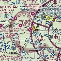
| Sectional chart |
|---|
|
| Airport distance calculator |
|---|
|
|
| Sunrise and sunset |
|---|
|
Times for 24-Apr-2025
| | Local
(UTC-5) | | Zulu
(UTC) |
|---|
| Morning civil twilight | | 06:34 | | 11:34 |
| Sunrise | | 06:58 | | 11:58 |
| Sunset | | 20:00 | | 01:00 |
| Evening civil twilight | | 20:24 | | 01:24 |
|
| Current date and time |
|---|
| Zulu (UTC) | 25-Apr-2025 03:21:45 |
|---|
| Local (UTC-5) | 24-Apr-2025 22:21:45 |
|---|
|
| METAR |
|---|
| KRBO | 250255Z AUTO 10009KT 10SM SCT017 BKN032 OVC090 26/23 A2995 RMK AO2 T02550229
|
KCRP
10nm E | 250251Z 10012KT 10SM BKN012 BKN020 OVC090 26/23 A2994 RMK AO2 SLP136 T02560228 53018
|
KT69
17nm NE | 250255Z AUTO 6SM BR CLR 25/24 A2995 RMK A01
|
KALI
18nm W | 250253Z AUTO 10010KT 9SM BKN016 OVC075 25/22 A2993 RMK AO2 SLP131 T02500222 53020
|
KNQI
18nm S | 250256Z 10008KT 10SM SCT015 BKN022 OVC075 26/24 A2993 RMK AO2 SLP132 T02610239 53021 $
|
|
| TAF |
|---|
KCRP
10nm E | 241730Z 2418/2518 14016G24KT P6SM SCT025 BKN045 FM250000 13012KT P6SM BKN025 FM250200 13010KT P6SM OVC015 FM250600 13008KT P6SM BKN008 OVC015 FM251500 15015G21KT P6SM BKN025
|
KALI
18nm W | 241730Z 2418/2518 13015G23KT P6SM SCT030 BKN045 FM250200 12010KT P6SM BKN025 FM250700 12005KT 5SM BR OVC015 TEMPO 2509/2513 4SM BR OVC009 FM251600 15013KT P6SM OVC025 FM251700 14013G19KT P6SM BKN050
|
KNQI
18nm S | 2423/2523 13013KT 9999 FEW022 FEW070 BKN250 QNH2983INS TEMPO 2423/2502 14009KT BKN018 BKN070 BKN250 FM250200 14007KT 9999 SCT008 BKN012 OVC030 QNH2987INS FM251500 15015KT 9999 SCT015 BKN030 BKN250 QNH2992INS TEMPO 2517/2523 14019G30KT SCT040 BKN250 AUTOMATED SENSOR METWATCH 2505 TIL 2512 TX30/2519Z TN26/2510Z FN20061
|
|
| NOTAMs |
|---|
NOTAMs are issued by the DoD/FAA and will open in a separate window not controlled by AirNav.
|
|


