FAA INFORMATION EFFECTIVE 20 FEBRUARY 2025
Location
| FAA Identifier: | TMK |
| Lat/Long: | 45-25-05.7000N 123-48-51.8000W
45-25.095000N 123-48.863333W
45.4182500,-123.8143889
(estimated) |
| Elevation: | 39.4 ft. / 12.0 m (surveyed) |
| Variation: | 20E (1985) |
| From city: | 3 miles S of TILLAMOOK, OR |
| Time zone: | UTC -8 (UTC -7 during Daylight Saving Time) |
| Zip code: | 97141 |
Airport Operations
| Airport use: | Open to the public |
| Activation date: | 07/1943 |
| Control tower: | no |
| ARTCC: | SEATTLE CENTER |
| FSS: | MC MINNVILLE FLIGHT SERVICE STATION |
| NOTAMs facility: | TMK (NOTAM-D service available) |
| Attendance: | 0900-1700 |
| Wind indicator: | lighted |
| Segmented circle: | yes |
| Lights: | ACTVT REIL RWY 13; MIRL RWY 13/31 AND RWY 01/19- CTAF. PAPI RWYS 13 & 31 AND RWYS 01 & 19 OPER CONT. |
| Beacon: | white-green (lighted land airport)
Operates sunset to sunrise. |
Airport Communications
| CTAF/UNICOM: | 122.8 |
| WX AWOS-3PT: | 120.0 (503-842-8792) |
- APCH/DEP CTL SVC PRVDD BY SEATTLE ARTCC (ZSE) ON FREQS 124.2/317.6 (SCAPPOOSE RCAG).
Nearby radio navigation aids
| VOR radial/distance | | VOR name | | Freq | | Var |
|---|
| UBGr255/35.5 | | NEWBERG VOR/DME | | 117.40 | | 21E |
| NDB name | | Hdg/Dist | | Freq | | Var | | ID |
|---|
| BANKS | | 233/34.7 | | 356 | | 16E | | PND | .--. -. -.. |
Airport Services
| Fuel available: | 100LL JET-A |
| Parking: | tiedowns |
| Airframe service: | NONE |
| Powerplant service: | NONE |
| Bottled oxygen: | NONE |
| Bulk oxygen: | NONE |
Runway Information
Runway 13/31
| Dimensions: | 5001 x 75 ft. / 1524 x 23 m |
| Surface: | asphalt, in good condition |
| Weight bearing capacity: | | Single wheel: | 60.0 | | Double wheel: | 75.0 | | Double tandem: | 125.0 |
|
| Runway edge lights: | medium intensity |
| Runway edge markings: | NRS FADED. |
| RUNWAY 13 | | RUNWAY 31 |
| Latitude: | 45-25.457730N | | 45-24.707923N |
| Longitude: | 123-49.135420W | | 123-48.655850W |
| Elevation: | 20.5 ft. | | 39.4 ft. |
| Traffic pattern: | left | | left |
| Runway heading: | 135 magnetic, 155 true | | 315 magnetic, 335 true |
| Markings: | nonprecision, in fair condition | | nonprecision, in fair condition |
| Visual slope indicator: | 2-light PAPI on left (3.00 degrees glide path) | | 2-light PAPI on left (3.50 degrees glide path) |
| Runway end identifier lights: | yes | | |
| Touchdown point: | yes, no lights | | yes, no lights |
| Obstructions: | 110 ft. trees, 2126 ft. from runway, 500 ft. right of centerline, 17:1 slope to clear | | 123 ft. tree, 2471 ft. from runway, 350 ft. right of centerline, 18:1 slope to clear |
Runway 1/19
| Dimensions: | 2911 x 75 ft. / 887 x 23 m |
| Surface: | asphalt, in good condition |
| Weight bearing capacity: | | Single wheel: | 40.0 | | Double wheel: | 46.0 | | Double tandem: | 67.0 |
|
| Runway edge lights: | medium intensity |
| Runway edge markings: | MARKINGS FADING AND CHIPPING. |
| RUNWAY 1 | | RUNWAY 19 |
| Latitude: | 45-24.908863N | | 45-25.320552N |
| Longitude: | 123-48.980423W | | 123-48.633520W |
| Elevation: | 28.7 ft. | | 35.6 ft. |
| Traffic pattern: | left | | right |
| Runway heading: | 010 magnetic, 030 true | | 190 magnetic, 210 true |
| Markings: | basic, in fair condition | | basic, in fair condition |
| Visual slope indicator: | 2-light PAPI on left (4.00 degrees glide path) | | 2-light PAPI on left (3.00 degrees glide path) |
| Touchdown point: | yes, no lights | | yes, no lights |
Airport Ownership and Management from official FAA records
| Ownership: | Publicly-owned |
| Owner: | PORT OF TILLAMOOK BAY
4000 BLIMP BLVD
TILLAMOOK, OR 97141
Phone (503) 842-7152 |
| Manager: | JAMES PEAK
4000 BLIMP BLVD
TILLAMOOK, OR 97141
Phone 503-842-2413
ALTERNATE NUMBER: 503-812-6192 |
Additional Remarks
| E94 | SAWRS |
| - | OCNL FLOCKS OF BIRDS ON OR NEAR ARPT. |
| - | ULTRALIGHT ACFT ON AND INVOF ARPT. |
| - | FOR CD CTC SEATTLE ARTCC AT 253-351-3694. |
Instrument Procedures
NOTE: All procedures below are presented as PDF files. If you need a reader for these files, you should download the free Adobe Reader.NOT FOR NAVIGATION. Please procure official charts for flight.
FAA instrument procedures published for use from 20 February 2025 at 0901Z to 20 March 2025 at 0900Z.
IAPs - Instrument Approach Procedures |
|---|
| RNAV (GPS) RWY 13 | |
download (321KB) |
|
|---|
| FETUJ THREE (OBSTACLE) (RNAV) | |
download (157KB) |
| NOTE: Special Take-Off Minimums/Departure Procedures apply | |
download (223KB) |
Other nearby airports with instrument procedures:
KMMV - Mc Minnville Municipal Airport (32 nm SE)
KHIO - Portland-Hillsboro Airport (37 nm E)
KAST - Astoria Regional Airport (44 nm N)
KUAO - Aurora State Airport (45 nm E)
KSPB - Scappoose Airport (45 nm NE)
|
|

Road maps at:
MapQuest
Bing
Google
| Aerial photo |
|---|
WARNING: Photo may not be current or correct
 Photo by Terence Shumaker
Photo taken 07-May-2012
looking northeast.
Photo by Terence Shumaker
Photo taken 07-May-2012
looking northeast.
Do you have a better or more recent aerial photo of Tillamook Airport that you would like to share? If so, please send us your photo.
|
| Sectional chart |
|---|
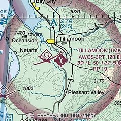
|
| Airport distance calculator |
|---|
|
|
| Sunrise and sunset |
|---|
|
Times for 14-Mar-2025
| | Local
(UTC-7) | | Zulu
(UTC) |
|---|
| Morning civil twilight | | 07:01 | | 14:01 |
| Sunrise | | 07:31 | | 14:31 |
| Sunset | | 19:18 | | 02:18 |
| Evening civil twilight | | 19:48 | | 02:48 |
|
| Current date and time |
|---|
| Zulu (UTC) | 14-Mar-2025 22:11:02 |
|---|
| Local (UTC-7) | 14-Mar-2025 15:11:02 |
|---|
|
| METAR |
|---|
| KTMK | 142155Z AUTO 17007G14KT 140V210 10SM BKN029 BKN039 OVC055 11/07 A2943 RMK AO2
|
|
| TAF |
|---|
KHIO
37nm E | 141728Z 1418/1518 VRB04KT P6SM -RA SCT035 OVC070 FM141900 14010KT P6SM -RA BKN015 OVC025 FM150400 18014G22KT P6SM -SHRA SCT015 OVC025 FM151400 19011KT P6SM -RA SCT025 OVC045
|
KAST
44nm N | 141728Z 1418/1518 10012G20KT P6SM -SHRA OVC035 FM142200 12011KT P6SM -RA SCT015 BKN025 OVC035 FM150600 22014G25KT P6SM -RA BKN015 OVC025
|
KUAO
45nm E | 141728Z 1418/1518 17009KT P6SM -RA BKN020 OVC035 FM142300 19014G24KT P6SM -RA OVC020 FM151400 20012G20KT P6SM -RA SCT025 OVC045
|
KSLE
46nm SE | 141728Z 1418/1518 VRB06KT P6SM -SHRA SCT025 OVC045 FM142100 18010G18KT P6SM -RA BKN025 OVC035 FM150300 19018G26KT P6SM -SHRA OVC025 FM151200 19012G24KT P6SM -RA SCT025 OVC045
|
|
| NOTAMs |
|---|
NOTAMs are issued by the DoD/FAA and will open in a separate window not controlled by AirNav.
|
|


