FAA INFORMATION EFFECTIVE 20 FEBRUARY 2025
Location
| FAA Identifier: | TOB |
| Lat/Long: | 44-01-04.7843N 092-49-53.8322W
44-01.079738N 092-49.897203W
44.0179956,-92.8316201
(estimated) |
| Elevation: | 1303.7 ft. / 397.4 m (surveyed) |
| Variation: | 02E (2000) |
| From city: | 1 mile SE of DODGE CENTER, MN |
| Time zone: | UTC -6 (UTC -5 during Daylight Saving Time) |
| Zip code: | 55927 |
Airport Operations
| Airport use: | Open to the public |
| Activation date: | 08/1950 |
| Control tower: | no |
| ARTCC: | MINNEAPOLIS CENTER |
| FSS: | PRINCETON FLIGHT SERVICE STATION |
| NOTAMs facility: | TOB (NOTAM-D service available) |
| Attendance: | MON-FRI 0700-1800 |
| Wind indicator: | lighted |
| Segmented circle: | no |
| Lights: | ACTVT OR INCR INTST REIL RWY 16 & 34; PAPI RWY 16 & 34; MIRL RWY 16/34 - CTAF. MIRL RWY 16/34 PRESET LOW INTST. |
| Beacon: | white-green (lighted land airport)
Operates sunset to sunrise. |
Airport Communications
| CTAF: | 122.9 |
| WX AWOS-3: | 119.075 (507-374-6369) |
| ROCHESTER APPROACH: | 119.8 |
| ROCHESTER DEPARTURE: | 119.8 |
| WX ASOS at RST (16 nm SE): | PHONE 507-216-8425 |
| WX AWOS-3 at OWA (19 nm W): | 128.325 (507-455-0642) |
- APCH/DEP SVC PRVDD BY MINNEAPOLIS ARTCC ON FREQS 132.35/307.3 (ROCHESTER RCAG) WHEN ROCHESTER APCH CTL CLSD.
Nearby radio navigation aids
| VOR radial/distance | | VOR name | | Freq | | Var |
|---|
| RSTr319/17.4 | | ROCHESTER VOR/DME | | 112.00 | | 05E |
| FOWr114/25.8 | | HALFWAY VOR/DME | | 111.20 | | 02E |
| AELr048/30.8 | | ALBERT LEA VOR/DME | | 109.80 | | 01E |
| FGTr152/39.7 | | FARMINGTON VORTAC | | 115.70 | | 06E |
Airport Services
| Fuel available: | 100LL JET-A
100LL:FUEL AVBL H24 SELF SVC VIA CREDIT CARD. |
| Parking: | hangars and tiedowns |
| Airframe service: | MAJOR |
| Powerplant service: | MAJOR |
Runway Information
Runway 16/34
| Dimensions: | 4500 x 75 ft. / 1372 x 23 m |
| Surface: | concrete, in good condition |
| Runway edge lights: | medium intensity |
| RUNWAY 16 | | RUNWAY 34 |
| Latitude: | 44-01.390690N | | 44-00.673230N |
| Longitude: | 092-49.957725W | | 092-49.702982W |
| Elevation: | 1298.8 ft. | | 1303.7 ft. |
| Traffic pattern: | left | | left |
| Runway heading: | 164 magnetic, 166 true | | 344 magnetic, 346 true |
| Markings: | nonprecision, in good condition | | nonprecision, in good condition |
| Visual slope indicator: | 4-light PAPI on left (3.00 degrees glide path) | | 4-light PAPI on left (3.00 degrees glide path) |
| Runway end identifier lights: | yes | | yes |
| Touchdown point: | yes, no lights | | yes, no lights |
Runway 4/22
| Dimensions: | 2383 x 200 ft. / 726 x 61 m |
| Surface: | turf, in good condition |
| Runway edge markings: | YELLOW CONES. |
| Operational restrictions: | NOT PLOWED WINTER MONTHS. |
| RUNWAY 4 | | RUNWAY 22 |
| Latitude: | 44-01.029135N | | 44-01.310788N |
| Longitude: | 092-50.212508W | | 092-49.834375W |
| Elevation: | 1289.9 ft. | | 1294.6 ft. |
| Traffic pattern: | left | | left |
| Runway heading: | 042 magnetic, 044 true | | 222 magnetic, 224 true |
| Runway end identifier lights: | no | | no |
| Touchdown point: | yes, no lights | | yes, no lights |
| Obstructions: | 2 ft. crops, 15 ft. from runway, 107 ft. left of centerline, 7:1 slope to clear | | none |
Airport Ownership and Management from official FAA records
| Ownership: | Publicly-owned |
| Owner: | CITY OF DODGE CENTER
23 W MAIN ST, PO BOX 430
DODGE CENTER, MN 55927-0430
Phone 507-374-2575 |
| Manager: | WAYNE TROM
806 AIRPORT DR S
DODGE CENTER, MN 55927-9173
Phone 507-374-6245 |
Additional Remarks
| - | WINDMILLS 1.5 NM SW OF ARPT. |
| - | ULTRALIGHT TFC ON & INVOF ARPT. |
| - | FOR CD CTC ROCHESTER APCH AT 507-424-8111. |
| - | ARR/DEP BLDG ACES CODE: 1304. |
Instrument Procedures
NOTE: All procedures below are presented as PDF files. If you need a reader for these files, you should download the free Adobe Reader.NOT FOR NAVIGATION. Please procure official charts for flight.
FAA instrument procedures published for use from 20 February 2025 at 0901Z to 20 March 2025 at 0900Z.
IAPs - Instrument Approach Procedures |
|---|
| RNAV (GPS) RWY 16 | |
download (260KB) |
| RNAV (GPS) RWY 34 | |
download (253KB) |
| VOR-A | |
download (195KB) |
| NOTE: Special Alternate Minimums apply | |
download (26KB) |
| NOTE: Special Take-Off Minimums/Departure Procedures apply | |
download (156KB) |
Other nearby airports with instrument procedures:
KRST - Rochester International Airport (16 nm SE)
KOWA - Owatonna Degner Regional Airport (19 nm W)
KAUM - Austin Municipal Airport (22 nm S)
KFBL - Faribault Municipal Airport-Liz Wall Strohfus Field (28 nm NW)
KAEL - Albert Lea Municipal Airport (31 nm SW)
|
|

Road maps at:
MapQuest
Bing
Google
| Aerial photo |
|---|
WARNING: Photo may not be current or correct
 Photo by Curtis R. Kooiman
Photo taken 19-May-2006
Photo by Curtis R. Kooiman
Photo taken 19-May-2006
Do you have a better or more recent aerial photo of Dodge Center Airport that you would like to share? If so, please send us your photo.
|
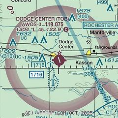
| Sectional chart |
|---|
|
| Airport distance calculator |
|---|
|
|
| Sunrise and sunset |
|---|
|
Times for 09-Mar-2025
| | Local
(UTC-6) | | Zulu
(UTC) |
|---|
| Morning civil twilight | | 06:07 | | 12:07 |
| Sunrise | | 06:35 | | 12:35 |
| Sunset | | 18:09 | | 00:09 |
| Evening civil twilight | | 18:37 | | 00:37 |
|
| Current date and time |
|---|
| Zulu (UTC) | 09-Mar-2025 23:11:37 |
|---|
| Local (UTC-6) | 09-Mar-2025 17:11:37 |
|---|
|
| METAR |
|---|
| KTOB | 092255Z AUTO 25011KT 10SM CLR 11/05 A2981 RMK AO2
|
K9MN
15nm E | 092248Z AUTO 27009G16KT 160V310 10SM CLR 13/03 A2981 RMK AO1
|
KRST
16nm SE | 092254Z 28013KT 10SM CLR 12/04 A2981 RMK AO2 SLP103 T01170039
|
KOWA
19nm W | 092255Z AUTO 22006KT 10SM CLR 10/07 A2980 RMK AO2 T01020071
|
|
| TAF |
|---|
KRST
16nm SE | 091724Z 0918/1018 25014G25KT P6SM SCT250 FM100000 24009KT P6SM FEW250
|
|
| NOTAMs |
|---|
NOTAMs are issued by the DoD/FAA and will open in a separate window not controlled by AirNav.
|
|


