FAA INFORMATION EFFECTIVE 20 FEBRUARY 2025
Location
| FAA Identifier: | VUO |
| Lat/Long: | 45-37-13.6290N 122-39-23.3580W
45-37.227150N 122-39.389300W
45.6204525,-122.6564883
(estimated) |
| Elevation: | 28.6 ft. / 8.7 m (surveyed) |
| Variation: | 16E (2015) |
| From city: | 2 miles SW of VANCOUVER, WA |
| Time zone: | UTC -8 (UTC -7 during Daylight Saving Time) |
| Zip code: | 98661 |
Airport Operations
| Airport use: | Open to the public |
| Activation date: | 01/1939 |
| Control tower: | no |
| ARTCC: | SEATTLE CENTER |
| FSS: | SEATTLE FLIGHT SERVICE STATION |
| NOTAMs facility: | VUO (NOTAM-D service available) |
| Attendance: | NOV-MAR 0800-1700, APR-OCT 0800-1800 |
| Pattern altitude: | 1028.6 ft. MSL |
| Wind indicator: | lighted |
| Segmented circle: | yes |
| Lights: | ACTVT PAPI RWY 26; MIRL RWY 08/26 - CTAF. |
Airport Communications
| CTAF: | 119.0 |
| WX ASOS: | 135.125 (360-696-1280) |
| PORTLAND APPROACH: | 118.1 ;100-279, HIGH 124.35 |
| PORTLAND DEPARTURE: | 124.35 |
| CLEARANCE DELIVERY: | 119.0 |
| WX ASOS at PDX (3 nm SE): | PHONE 458-212-2405 |
| WX ASOS at TTD (12 nm E): | 135.625 (503-492-2887) |
| WX ASOS at SPB (12 nm NW): | 135.875 (503-543-6401) |
| WX ASOS at HIO (13 nm W): | PHONE 503-615-4314 |
- ARRIVALS CONTACT PEARSON ADVISORY ON 119.0 PRIOR TO ENTERING CLASS D AIRSPACE FOR TRAFFIC AND WAKE TURBULENCE ADVISORIES, DEPARTURES CONTACT PEARSON ADVISORY ON 119.0 PRIOR TO DEPARTURE.
- CLASS D VFR ADVSY SVC FREQ 119.0.
- COMMUNICATIONS PRVDD BY SEATTLE RADIO ON FREQ 122.5 (VANCOUVER RCO).
Nearby radio navigation aids
| VOR radial/distance | | VOR name | | Freq | | Var |
|---|
| BTGr179/8.1 | | BATTLE GROUND VORTAC | | 116.60 | | 21E |
| UBGr019/21.0 | | NEWBERG VOR/DME | | 117.40 | | 21E |
| NDB name | | Hdg/Dist | | Freq | | Var | | ID |
|---|
| BANKS | | 076/16.3 | | 356 | | 16E | | PND | .--. -. -.. |
Airport Services
| Fuel available: | 100LL
100LL:SELF SVC CREDIT CARD H24. |
| Parking: | tiedowns |
| Airframe service: | MAJOR |
| Powerplant service: | MAJOR |
| Bulk oxygen: | LOW |
Runway Information
Runway 8/26
| Dimensions: | 3275 x 60 ft. / 998 x 18 m
STWY W END. |
| Surface: | asphalt, in good condition |
| Runway edge lights: | medium intensity
2513 FT LGTD AT NIGHT. |
| RUNWAY 8 | | RUNWAY 26 |
| Latitude: | 45-37.265567N | | 45-37.188717N |
| Longitude: | 122-39.769400W | | 122-39.009200W |
| Elevation: | 28.6 ft. | | 22.2 ft. |
| Traffic pattern: | left | | right |
| Runway heading: | 082 magnetic, 098 true | | 262 magnetic, 278 true |
| Displaced threshold: | no | | 762 ft.
FOR NIGHT OPS. |
| Declared distances: | TORA:3275 TODA:3275 ASDA:3065 LDA:3065 | | TORA:3275 TODA:3275 ASDA:3275 LDA:2513 |
| Markings: | basic, in fair condition | | basic, in fair condition |
| Visual slope indicator: | 4-box VASI on right (3.75 degrees glide path)
VASI RWY 08 UNUSBL BYD 6 DEG L OR R OF RWY CNTRLN. | | 2-light PAPI on right (4.00 degrees glide path) |
| Runway end identifier lights: | no | | yes |
| Touchdown point: | yes, no lights | | yes, no lights |
| Obstructions: | 218 ft. brdg, 2647 ft. from runway, 482 ft. right of centerline, 11:1 slope to clear | | 31 ft. tree, 280 ft. from runway, 2:1 slope to clear
+16 FT DIKE AT 115 FT; 6 FT FENCE AT 130 FT. |
Airport Ownership and Management from official FAA records
| Ownership: | Publicly-owned |
| Owner: | CITY OF VANCOUVER &NPS
PO BOX 1995
VANCOUVER, WA 98660
Phone 360-487-8619 |
| Manager: | MEREDITH FOX
PO BOX 1995
VANCOUVER, WA 98660
Phone 360-487-8619
360-904-9007. |
Additional Remarks
| - | PPR TO ACESS AIR MUSEUM TXL. |
| - | OPS OVR CNTRLN OR EXTDD CNTRLN MNTN AT OR BLW 700 FT MSL DUE TO PORTLAND INTL TFC; PORTLAND INTL RWY 10L/28R EXTDD CNTRLN XS RWY 08 THR. |
| - | GEESE ON &INVOF ARPT. |
| - | OTFC FORT VANCOUVER STOCKADE NATIONAL PARK 360 FT N OF RWY 08 NA. |
| - | ARR PRIOR TO ENTERING SFRA FAR 93.163 & DEP BFR TKOF - CTC CTAF. |
| - | MANDATORY VFR ADVZY SVC - CTC CTAF. |
| - | SEE SPL NOTICE FOR FULL PROC APCH - 866-640-4124. |
Instrument Procedures
NOTE: All procedures below are presented as PDF files. If you need a reader for these files, you should download the free Adobe Reader.NOT FOR NAVIGATION. Please procure official charts for flight.
FAA instrument procedures published for use from 20 February 2025 at 0901Z to 20 March 2025 at 0900Z.
IAPs - Instrument Approach Procedures |
|---|
| RNAV (GPS)-B | |
download (252KB) |
| NOTE: Special Alternate Minimums apply | |
download (187KB) |
| NOTE: Special Take-Off Minimums/Departure Procedures apply | |
download (523KB) |
Other nearby airports with instrument procedures:
KPDX - Portland International Airport (3 nm SE)
KTTD - Portland-Troutdale Airport (12 nm E)
KSPB - Scappoose Airport (12 nm NW)
KHIO - Portland-Hillsboro Airport (13 nm W)
KUAO - Aurora State Airport (23 nm S)
|
|

Road maps at:
MapQuest
Bing
Google
| Aerial photo |
|---|
WARNING: Photo may not be current or correct
 Photo by Adam S. Queen
Taken in July 2014
looking north.
Photo by Adam S. Queen
Taken in July 2014
looking north.
Do you have a better or more recent aerial photo of Pearson Field Airport that you would like to share? If so, please send us your photo.
|
| Sectional chart |
|---|
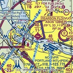
|
| Airport distance calculator |
|---|
|
|
| Sunrise and sunset |
|---|
|
Times for 13-Mar-2025
| | Local
(UTC-8) | | Zulu
(UTC) |
|---|
| Morning civil twilight | | 05:58 | | 13:58 |
| Sunrise | | 06:28 | | 14:28 |
| Sunset | | 18:12 | | 02:12 |
| Evening civil twilight | | 18:42 | | 02:42 |
|
| Current date and time |
|---|
| Zulu (UTC) | 13-Mar-2025 20:41:39 |
|---|
| Local (UTC-8) | 13-Mar-2025 12:41:39 |
|---|
|
| METAR |
|---|
| KVUO | 131953Z AUTO 21006G17KT 10SM SCT036 BKN065 BKN090 07/03 A2973 RMK AO2 SLP069 T00670028 $
|
KPDX
3nm SE | 131953Z 20008KT 10SM -RA BKN033CB BKN065 BKN080 07/03 A2972 RMK AO2 PK WND 22026/1942 RAB43 SLP062 CB E MOV NE P0000 T00720028 $
|
KTTD
11nm SE | 131953Z 26012G20KT 10SM -RA BKN032 BKN045 OVC090 08/02 A2972 RMK AO2 RAB49 SLP064 P0000 T00780017
|
KSPB
12nm NW | 131953Z AUTO 22010G18KT 10SM -RA BKN070 OVC090 07/02 A2970 RMK AO2 RAB00E26B46 SLP058 P0000 T00670017
|
KHIO
13nm W | 131953Z 32013G19KT 10SM FEW026 SCT033 BKN040 08/03 A2971 RMK AO2 RAB25E41 SLP061 P0000 T00780028 $
|
|
| TAF |
|---|
KPDX
3nm SE | 131727Z 1318/1418 17008KT P6SM -SHRA FEW012 BKN045 FM131900 21010G18KT P6SM -SHRA SCT035 BKN045 PROB30 1319/1401 4SM TSRA BKN025CB FM140300 17007KT P6SM -SHRA BKN070 TEMPO 1408/1411 4SM -SHRA BR BKN030 FM141100 11006KT P6SM OVC050
|
KTTD
11nm SE | 131727Z 1318/1418 22008KT P6SM -SHRA BKN012 OVC050 FM131900 22010G18KT P6SM -SHRA SCT025 BKN050 PROB30 1319/1401 4SM TSRA BKN050CB FM140300 12005KT P6SM -SHRA BKN070
|
KHIO
13nm W | 131727Z 1318/1418 21010G16KT P6SM -SHRA BKN050 PROB30 1319/1401 4SM TSRA BKN025CB FM140200 19005KT P6SM -SHRA BKN070 TEMPO 1408/1411 4SM -SHRA BR BKN030 FM141100 11006KT P6SM OVC050
|
|
| NOTAMs |
|---|
NOTAMs are issued by the DoD/FAA and will open in a separate window not controlled by AirNav.
|
|


