FAA INFORMATION EFFECTIVE 17 APRIL 2025
Location
| FAA Identifier: | VVV |
| Lat/Long: | 45-18-14.8660N 096-25-28.5920W
45-18.247767N 096-25.476533W
45.3041294,-96.4246089
(estimated) |
| Elevation: | 1101.2 ft. / 335.6 m (surveyed) |
| Variation: | 05E (2000) |
| From city: | 1 mile SE of ORTONVILLE, MN |
| Time zone: | UTC -5 (UTC -6 during Standard Time) |
| Zip code: | 56278 |
Airport Operations
| Airport use: | Open to the public |
| Activation date: | 12/1945 |
| Control tower: | no |
| ARTCC: | MINNEAPOLIS CENTER |
| FSS: | PRINCETON FLIGHT SERVICE STATION |
| NOTAMs facility: | VVV (NOTAM-D service available) |
| Attendance: | UNATNDD |
| Wind indicator: | lighted |
| Segmented circle: | yes |
| Lights: | ACTVT OR INCR INTST PAPI RWY 16 & 34; MIRL RWY 16/34 - CTAF. MIRL RWY 16/34 PRESET LOW INTST. |
| Beacon: | white-green (lighted land airport)
Operates sunset to sunrise. |
Airport Communications
| CTAF/UNICOM: | 122.8 |
| WX AWOS-3: | 119.225 (320-839-2363) |
| WX AWOS-3P at 1D1 (7 nm SW): | 118.9 (605-438-2088) |
| WX AWOS-3 at AQP (18 nm E): | 118.5 (320-289-1265) |
- APCH/DEP SVC PRVDD BY MINNEAPOLIS ARTCC ON FREQS 128.5/306.2 (WATERTOWN RCAG).
Nearby radio navigation aids
| VOR radial/distance | | VOR name | | Freq | | Var |
|---|
| MOXr226/24.8 | | MORRIS VOR/DME | | 109.60 | | 05E |
| MVEr298/36.1 | | MONTEVIDEO VOR/DME | | 111.60 | | 05E |
Airport Services
| Fuel available: | 100LL JET-A
100LL:FUEL AVBL H24 SELF SVC VIA CREDIT CARD. |
| Parking: | tiedowns |
| Airframe service: | NONE |
| Powerplant service: | NONE |
| Bottled oxygen: | NONE |
| Bulk oxygen: | NONE |
Runway Information
Runway 16/34
| Dimensions: | 3417 x 75 ft. / 1042 x 23 m |
| Surface: | asphalt, in fair condition
LOOSE AGGREGATE. |
| Weight bearing capacity: | |
| Runway edge lights: | medium intensity |
| RUNWAY 16 | | RUNWAY 34 |
| Latitude: | 45-18.615450N | | 45-18.064333N |
| Longitude: | 096-25.544433W | | 096-25.386300W |
| Elevation: | 1101.2 ft. | | 1094.6 ft. |
| Traffic pattern: | left | | left |
| Runway heading: | 164 magnetic, 169 true | | 344 magnetic, 349 true |
| Markings: | nonprecision, in good condition | | nonprecision, in good condition |
| Visual slope indicator: | 4-light PAPI on left (3.00 degrees glide path) | | 4-light PAPI on left (3.00 degrees glide path) |
| Runway end identifier lights: | no | | no |
| Touchdown point: | yes, no lights | | yes, no lights |
Runway 4/22
| Dimensions: | 2175 x 275 ft. / 663 x 84 m |
| Surface: | turf, in good condition |
| Runway edge markings: | YELLOW CONES. |
| RUNWAY 4 | | RUNWAY 22 |
| Latitude: | 45-17.981333N | | 45-18.224667N |
| Longitude: | 096-25.680000W | | 096-25.308167W |
| Elevation: | 1092.4 ft. | | 1094.7 ft. |
| Traffic pattern: | left | | left |
| Runway heading: | 042 magnetic, 047 true | | 222 magnetic, 227 true |
| Runway end identifier lights: | no | | no |
| Touchdown point: | yes, no lights | | yes, no lights |
| Obstructions: | none | | 32 ft. trees, 642 ft. from runway, 113 ft. right of centerline, 20:1 slope to clear |
Airport Ownership and Management from official FAA records
| Ownership: | Publicly-owned |
| Owner: | CITY OF ORTONVILLE
315 MADISON AVE
ORTONVILLE, MN 56278-1325
Phone 320-839-3428 |
| Manager: | CHARLEEN GROSSMAN
315 MADISON AVE
ORTONVILLE, MN 56278-1325
Phone 320-839-3428 |
Additional Remarks
| - | GCO AVBL ON FREQ 121.725 THRU MINNEAPOLIS ARTCC & FLT SVCS. |
| - | WILDLIFE & WATERFOWL INVOF ARPT. |
| - | ARPT UNMON MON-FRI 1700-0800 & WKENDS. |
| - | FOR CD IF UNA VIA GCO CTC MINNEAPOLIS ARTCC AT 651-463-5588. |
Instrument Procedures
NOTE: All procedures below are presented as PDF files. If you need a reader for these files, you should download the free Adobe Reader.NOT FOR NAVIGATION. Please procure official charts for flight.
FAA instrument procedures published for use from 17 April 2025 at 0901Z to 15 May 2025 at 0900z.
IAPs - Instrument Approach Procedures |
|---|
| RNAV (GPS) RWY 34 | |
download (196KB) |
| NOTE: Special Alternate Minimums apply | |
download (175KB) |
| NOTE: Special Take-Off Minimums/Departure Procedures apply | |
download (406KB) |
Other nearby airports with instrument procedures:
1D1 - Milbank Municipal Airport (7 nm SW)
KAQP - Appleton Municipal Airport (18 nm E)
KDXX - Lac Qui Parle County Airport (22 nm SE)
KMOX - Morris Municipal Airport - Charlie Schmidt Field (25 nm NE)
KETH - Wheaton Municipal Airport (29 nm N)
|
|

Road maps at:
MapQuest
Bing
Google
| Aerial photo |
|---|
WARNING: Photo may not be current or correct

Do you have a better or more recent aerial photo of Ortonville Municipal Airport/Martinson Field that you would like to share? If so, please send us your photo.
|
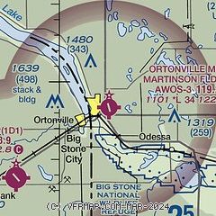
| Sectional chart |
|---|
|
| Airport distance calculator |
|---|
|
|
| Sunrise and sunset |
|---|
|
Times for 27-Apr-2025
| | Local
(UTC-5) | | Zulu
(UTC) |
|---|
| Morning civil twilight | | 05:49 | | 10:49 |
| Sunrise | | 06:21 | | 11:21 |
| Sunset | | 20:25 | | 01:25 |
| Evening civil twilight | | 20:58 | | 01:58 |
|
| Current date and time |
|---|
| Zulu (UTC) | 27-Apr-2025 18:27:31 |
|---|
| Local (UTC-5) | 27-Apr-2025 13:27:31 |
|---|
|
| METAR |
|---|
| KVVV | 271815Z AUTO 17017G22KT 10SM OVC025 17/12 A2991 RMK AO2
|
KAQP
19nm E | 271813Z AUTO 16013G20KT 10SM OVC020 16/11 A2994 RMK AO2 TSNO
|
|
| TAF |
|---|
KATY
39nm SW | 271723Z 2718/2818 17019G28KT P6SM OVC011 FM280100 15013G21KT P6SM OVC007 FM280900 16014G22KT 4SM -TSRA OVC003CB FM281200 18015G23KT P6SM OVC007 FM281600 20016G25KT P6SM VCTS OVC015CB
|
|
| NOTAMs |
|---|
NOTAMs are issued by the DoD/FAA and will open in a separate window not controlled by AirNav.
|
|


