FAA INFORMATION EFFECTIVE 23 JANUARY 2025
Location
| FAA Identifier: | N58 |
| Lat/Long: | 39-33-35.2587N 119-14-33.5634W
39-33.587645N 119-14.559390W
39.5597941,-119.2426565
(estimated) |
| Elevation: | 4346 ft. / 1325 m (estimated) |
| Variation: | 16E (1985) |
| From city: | 3 miles S of FERNLEY, NV |
| Time zone: | UTC -8 (UTC -7 during Daylight Saving Time) |
| Zip code: | 89408 |
Airport Operations
| Airport use: | Open to the public |
| Activation date: | 08/1991 |
| Control tower: | no |
| ARTCC: | OAKLAND CENTER |
| FSS: | RENO FLIGHT SERVICE STATION |
| NOTAMs facility: | RNO (NOTAM-D service available) |
| Attendance: | MON-FRI 0700-1900
MON-FRI |
| Wind indicator: | yes |
| Segmented circle: | yes |
| Beacon: | white-green (lighted land airport)
Operates sunset to sunrise. |
Airport Communications
| CTAF: | 122.9 |
| WX AWOS-2 at SPZ (9 nm S): | 120.475 (775-577-2624) |
Nearby radio navigation aids
| VOR radial/distance | | VOR name | | Freq | | Var |
|---|
| HZNr266/11.6 | | HAZEN VORTAC | | 114.10 | | 17E |
| FMGr069/19.2 | | MUSTANG VORTAC | | 117.90 | | 16E |
Airport Services
| Parking: | hangars and tiedowns |
Runway Information
Runway 15/33
| Dimensions: | 3974 x 40 ft. / 1211 x 12 m |
| Surface: | asphalt, in poor condition
2-4 FT DITCHES IN PRI SFC & RWY SAFETY AREA PARALLEL TO RWY 10 FT FM RWY EDGE. |
| Operational restrictions: | EFF GRADIENT 2 PERCENT S. |
| RUNWAY 15 | | RUNWAY 33 |
| Latitude: | 39-33.813440N | | 39-33.187913N |
| Longitude: | 119-14.513073W | | 119-14.264715W |
| Elevation: | 4278.4 ft. | | 4330.5 ft. |
| Traffic pattern: | right | | left |
| Runway heading: | 147 magnetic, 163 true | | 327 magnetic, 343 true |
| Markings: | numbers only, in fair condition | | numbers only, in fair condition |
| Touchdown point: | yes, no lights | | yes, no lights |
| Obstructions: | none | | 70 ft. hill, 1640 ft. from runway, 20:1 slope to clear
+4 FT FENCE 75 FT FM THR. |
Runway 5/23
| Dimensions: | 2750 x 30 ft. / 838 x 9 m |
| Surface: | gravel/dirt, in fair condition
MNT WET WX RWY CONDS - AMGR. |
| Operational restrictions: | EFF GRADIENT 4 PERCENT W; DEP RWY 05 & ARR RWY 23 DUE TO SLP. |
| RUNWAY 5 | | RUNWAY 23 |
| Latitude: | 39-33.619408N | | 39-33.807235N |
| Longitude: | 119-15.071987W | | 119-14.539553W |
| Elevation: | 4325.9 ft. | | 4280.2 ft. |
| Traffic pattern: | left | | left |
| Runway heading: | 050 magnetic, 066 true | | 230 magnetic, 246 true |
| Markings: | none, in poor condition | | none, in poor condition |
| Touchdown point: | yes, no lights | | yes, no lights |
| Obstructions: | 15 ft. road, 100 ft. from runway, 6:1 slope to clear | | 440 ft. hill, 2640 ft. from runway, 6:1 slope to clear |
Airport Ownership and Management from official FAA records
| Ownership: | Publicly-owned |
| Owner: | SAMSARG TF, LLC
GREG JOHNSON, MANAGER, 204 WEST SPEAR STREET
CARSON CITY, NV 89703
Phone 775-471-7301
BUREAU OF LAND MGMT - 775-861-6400 |
| Manager: | JOSH GRISWALD
PO BOX 283
SILVER SPRINGS, NV 89429
Phone 775-471-7302 |
Additional Remarks
| - | FOR CD CTC NORCAL APCH AT 916-361-0596. |
| - | ARPT FRQLY CLSD FOR MODEL ACFT; REMOTE ACFT OPS ON & INVOF ARPT; RDO USE ENCOURAGED. |
| - | HEL TRG RSTRD TO PAVED RWY ENDS; LIMIT TAXI & HOVER PRAC TO RAMP AREAS. |
| - | HORSE & CATTLE FRQLY ON & INVOF RWYS & TWYS. |
| - | 1740 FT OVRN NW OF RWY 15 END NOT ARPT PROPERTY; MAY BE MISTAKEN FOR DSPLCD THR. |
Instrument Procedures
There are no published instrument procedures at N58.
Some nearby airports with instrument procedures:
KSPZ - Silver Springs Airport (9 nm S)
KFLX - Fallon Municipal Airport (23 nm E)
KRNO - Reno/Tahoe International Airport (25 nm W)
KNFL - Fallon Naval Air Station (Van Voorhis Field) Airport (27 nm E)
KRTS - Reno/Stead Airport (30 nm W)
|
|

Road maps at:
MapQuest
Bing
Google
| Aerial photo |
|---|
WARNING: Photo may not be current or correct
 Photo by Bob Lenox
Do you have a better or more recent aerial photo of Samsarg Field Airport that you would like to share? If so, please send us your photo.
|
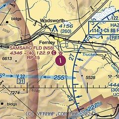
| Sectional chart |
|---|
|
| Airport distance calculator |
|---|
|
|
| Sunrise and sunset |
|---|
|
Times for 06-Feb-2025
| | Local
(UTC-8) | | Zulu
(UTC) |
|---|
| Morning civil twilight | | 06:32 | | 14:32 |
| Sunrise | | 07:01 | | 15:01 |
| Sunset | | 17:22 | | 01:22 |
| Evening civil twilight | | 17:50 | | 01:50 |
|
| Current date and time |
|---|
| Zulu (UTC) | 07-Feb-2025 02:56:59 |
|---|
| Local (UTC-8) | 06-Feb-2025 18:56:59 |
|---|
|
| TAF |
|---|
KRNO
25nm W | 062040Z 0621/0718 18015G25KT 5SM -SHRASN BKN035 WS020/20050KT FM062200 18015G25KT 5SM -SHRA SCT035 OVC070 WS020/21050KT FM070400 18022G32KT P6SM BKN050 WS020/22055KT FM070900 22031G40KT P6SM SCT070 BKN100 WS020/23060KT PROB30 0709/0712 4SM -SHRASN BKN035 FM071300 25020G30KT P6SM BKN100 WS020/24050KT
|
KNFL
27nm E | 0623/0723 22009G15KT 9999 VCSH SCT050 BKN090 140 620509 520009 540909 QNH2963INS TEMPO 0623/0705 8000 -SHRA SCT030 OVC050 FM070600 22015G25KT 9999 SCT050 BKN100 BKN180 620609 520009 540909 QNH292959INS FM071200 24019G32KT 9999 FEW050 SCT100 SCT180 600000 540009 550909 551809 QNH2968INS FM071700 27023G42KT 8000 VCBLDU FEW050 SCT100 SCT180 540009 550909 551809 QNH2990INS FM072200 28014G24KT 9999 FEW050 SCT100 SCT180 540009 550909 551809 QNH2994INS AUTOMATED SENSOR METWATCH 0707 TIL 0715 TX11/0623Z
|
|
| NOTAMs |
|---|
NOTAMs are issued by the DoD/FAA and will open in a separate window not controlled by AirNav.
|
|


