FAA INFORMATION EFFECTIVE 23 JANUARY 2025
Location
| FAA Identifier: | CZF |
| Lat/Long: | 61-46-51.6517N 166-02-22.4715W
61-46.860862N 166-02.374525W
61.7810144,-166.0395754
(estimated) |
| Elevation: | 467 ft. / 142.3 m (surveyed) |
| Variation: | 08E (2025) |
| From city: | 6 miles SE of CAPE ROMANZOF, AK |
| Time zone: | UTC -9 (UTC -8 during Daylight Saving Time) |
| Zip code: | 99662 |
Airport Operations
| Airport use: | Private use, CLSD TO PUBLIC; OFFL BUS ONLY. |
| Activation date: | 01/1959 |
| Control tower: | no |
| ARTCC: | ANCHORAGE CENTER |
| FSS: | KENAI FLIGHT SERVICE STATION [907-283-7211] |
| NOTAMs facility: | PACZ (NOTAM-D service available) |
| Attendance: | MON-FRI 1700-0200Z++
CLSD FED HOL. |
| Wind indicator: | yes |
| Segmented circle: | yes |
| Lights: | ON CONSLY. |
Airport Communications
| CTAF: | 126.2 |
| WX AWOS-3: | PHONE 907-552-2869 |
| WX AWOS-3P at SCM (14 nm E): | 118.425 (907-558-5501) |
| WX AWOS-3P at HPB (16 nm S): | 135.1 (907-758-4211) |
| WX AWOS-3P at VAK (19 nm SE): | 120.625 (907-858-7600) |
- APCH/DEP SVC PRVDD BY ANCHORAGE ARTCC ON FREQS 124.5/266.8 (CAPE ROMANZOF RCAG).
Nearby radio navigation aids
| VOR radial/distance | | VOR name | | Freq | | Var |
|---|
| HPBr357/16.2 | | HOOPER BAY VOR/DME | | 115.20 | | 13E |
| NDB name | | Hdg/Dist | | Freq | | Var | | ID |
|---|
| CAPE ROMANZOF | | 246/2.1 | | 275 | | 08E | | CZF | -.-. --.. ..-. |
Airport Services
Runway Information
Runway 2/20
| Dimensions: | 3955 x 120 ft. / 1205 x 37 m |
| Surface: | gravel |
| Operational restrictions: | RWY ON SIDE OF 2100 FT MT; APCH FM SW; LND RWY 02 & TKOF RWY 20; HIGH TRRN BOTH SIDES & N RWY END. SUCCESSFUL GO AROUND IMPROBABLE. |
| RUNWAY 2 | | RUNWAY 20 |
| Latitude: | 61-46.577130N | | 61-47.144628N |
| Longitude: | 166-02.707128W | | 166-02.041923W |
| Elevation: | 374.0 ft. | | 467.0 ft. |
| Traffic pattern: | left | | left |
| Runway heading: | 021 magnetic, 029 true | | 201 magnetic, 209 true |
| Markings: | NSTD, in fair condition | | NSTD, in fair condition |
| Visual slope indicator: | 2-light PAPI on right (3.00 degrees glide path) | | |
| Runway end identifier lights: | yes | | no |
| Touchdown point: | yes, no lights | | yes, no lights |
| Obstructions: | none | | ridge, 5280 ft. from runway, 12:1 slope to clear |
Airport Ownership and Management from official FAA records
| Ownership: | U.S. Air Force |
| Owner: | U.S. AIR FORCE
611TH AIR SUPPORT GROUP, 10471 20TH STREET, SUITE 361
ELMENDORF AFB, AK 99506-2270
Phone 907-552-3442 |
| Manager: | NICK HILTON
611TH AIR SUPPORT SQUADRON, 10471 20TH STREET, SUITE 222
ELMENDORF AFB, AK 99506-2270
Phone 907-552-7610 |
Additional Remarks
| - | PPR ALL OPS; 24 HR BFR SKED ARR & NO LATER THAN 1 HR PRIOR TO DEP FOR SITE - D317-552-9419/9370/C907-552-9419/9370. |
| - | PAX MUST COORD BFR NON EMERG TRAVEL TO SITE - D317-552-4935/1089/C907-552-4935/1089. |
| - | CTN: SHARP DROPOFF W SIDE OF RWY; RSTR 180 DEG TURNS TO N END APRON AREA. |
| - | WX MEASURING EQUIP APCH END RWY 02 R SIDE. MKRS 250 FT APART FULL LEN. |
| - | CTN: WINDS FM 070-150 MAY BE STRONGER THAN RPRTD. WIND OVR 20 KTS PSBL SVR TURB. |
| - | DALGT OPS ONLY. |
| - | AFT CTC ON 126.2 OR 121.5 EXP 30 MIN DLA FOR FICON. |
| - | USAF FAC; CIV ACFT LNDG PMT RQRD BFR 30 DAY PPR ISSUED; NON CALP OPS FINED & RPTD TO USAF OPRG INSTRNS - D317-552-5282/C907-552-5282 OR MAIL ATTN: 11 AF AMGR 10471 20TH STREET SUITE 218 ELMENDORF AFB AK 99506. |
| - | ALERT: INCRD RISK IN ADDN TO WILDLIFE RISK ANALYSIS HAZ; GULLS INVOF ARPT JUNE; GEESE & SWANS AUG-SEP; DURG HERRING FISHERY ACT GULLS ON BEACH BLW APCH TO RWY; DILIGENCE RCMDD. |
Instrument Procedures
NOTE: All procedures below are presented as PDF files. If you need a reader for these files, you should download the free Adobe Reader.NOT FOR NAVIGATION. Please procure official charts for flight.
FAA instrument procedures published for use from 23 January 2025 at 0901Z to 20 February 2025 at 0900z.
IAPs - Instrument Approach Procedures |
|---|
| RNAV (GPS) RWY 02 **CHANGED** | |
download (75KB) |
| RNAV (GPS)-A **CHANGED** | |
download (70KB) |
| NDB/DME RWY 02 **CHANGED** | |
download (147KB) |
Departure Procedures |
|---|
| HUDEM ONE (RNAV) | |
download (72KB) |
|
|---|
| CAPE ROMANZOF SIX (OBSTACLE) **CHANGED** | |
download (82KB) |
| NOTE: Special Take-Off Minimums/Departure Procedures apply | |
download (390KB) |
Other nearby airports with instrument procedures:
PACM - Scammon Bay Airport (14 nm E)
PAHP - Hooper Bay Airport (16 nm S)
PAVA - Chevak Airport (19 nm SE)
PAMO - Mountain Village Airport (69 nm E)
PAEM - Emmonak Airport (74 nm NE)
|
|

Road maps at:
MapQuest
Bing
Google
| Aerial photo |
|---|
WARNING: Photo may not be current or correct

Do you have a better or more recent aerial photo of Cape Romanzof LRRS Airport that you would like to share? If so, please send us your photo.
|
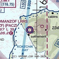
| Sectional chart |
|---|
|
| Airport distance calculator |
|---|
|
|
| Sunrise and sunset |
|---|
|
Times for 06-Feb-2025
| | Local
(UTC-9) | | Zulu
(UTC) |
|---|
| Morning civil twilight | | 09:26 | | 18:26 |
| Sunrise | | 10:15 | | 19:15 |
| Sunset | | 18:21 | | 03:21 |
| Evening civil twilight | | 19:11 | | 04:11 |
|
| Current date and time |
|---|
| Zulu (UTC) | 07-Feb-2025 08:19:49 |
|---|
| Local (UTC-9) | 06-Feb-2025 23:19:49 |
|---|
|
| METAR |
|---|
| PACZ | 070759Z AUTO 00000KT 5SM -FZRA OVC015 M03/M04 A3006 RMK AO2 SLP189
|
PAVA
19nm SE | 070756Z AUTO 11005KT 10SM OVC016 M03/M04 A3012 RMK AO2 SLP200 T10331039 FZRANO
|
|
| NOTAMs |
|---|
NOTAMs are issued by the DoD/FAA and will open in a separate window not controlled by AirNav.
|
|


