FAA INFORMATION EFFECTIVE 23 JANUARY 2025
Location
| FAA Identifier: | ADQ |
| Lat/Long: | 57-44-59.2580N 152-29-38.1970W
57-44.987633N 152-29.636617W
57.7497939,-152.4939436
(estimated) |
| Elevation: | 78.7 ft. / 24.0 m (surveyed) |
| Variation: | 14E (2020) |
| From city: | 4 miles SW of KODIAK, AK |
| Time zone: | UTC -9 (UTC -8 during Daylight Saving Time) |
| Zip code: | 99615 |
Airport Operations
| Airport use: | Open to the public |
| Activation date: | 04/1948 |
| Control tower: | yes |
| ARTCC: | ANCHORAGE CENTER |
| FSS: | KENAI FLIGHT SERVICE STATION [907-283-7211] |
| NOTAMs facility: | ADQ (NOTAM-D service available) |
| Attendance: | SAME AS ARPT MAINT HRS
ARPT INFO - 907-487-4952 MON-FRI 0700-1630. |
| Wind indicator: | lighted |
| Segmented circle: | yes |
| Lights: | ACTVT REIL RWY 01 & 26; VASI RWY 01, 26, 29; HIRL RWY 01/19, 08/26, 11/29; TWY LGTS - CTAF. |
| Beacon: | white-green (lighted land airport)
Operates sunset to sunrise. |
| Fire and rescue: | ARFF index B |
| Airline operations: | CLSD TO ACR OPS GTR THAN 30 PAX SEATS EXC PPR IN WRITING - AMGR P.O. BOX 1500 ANTON LARSON ROAD KODIAK AK 99615. |
Airport Communications
| CTAF: | 119.8 |
| UNICOM: | 122.8 |
| ATIS: | 134.45 |
| WX ASOS: | PHONE 907-487-2442 |
| KODIAK GROUND: | 121.9 [0630-2000 1 OCT-31 MAR, 0700-2200 1 APR-30 SEP.] |
| KODIAK TOWER: | 119.8 239.0 [0630-2000 1 OCT-31 MAR, 0700-2200 1 APR-30 SEP.] |
| EMERG: | 121.5 243.0 |
- TWR PROVIDES TFC INFO TO KODIAK MUNI AND SEAPLANE BASE ON LCL CTL FREQ.
- FREQ 119.8 IS CTAF AT KODIAK ARPT - KODIAK MUNI - INNER HARBOR SEAPLANE & KODIAK SEAPLANE.
- OPERATIONS FREQS ARE 345.0 156.8 5696X 2182 SSB AND 2678 SSB.
- APCH/DEP SVC PRVDD BY ANCHORAGE ARTCC ON FREQS 125.1/281.4 (KODIAK RCAG).
Nearby radio navigation aids
| VOR radial/distance | | VOR name | | Freq | | Var |
|---|
| ODKr239/5.2 | | KODIAK VOR/DME | | 117.10 | | 14E |
| NDB name | | Hdg/Dist | | Freq | | Var | | ID |
|---|
| WOODY ISLAND | | 241/5.6 | | 394 | | 14E | | RWO | .-. .-- --- |
Airport Services
| Fuel available: | 100LL JET-A1 |
| Airframe service: | MINOR |
| Powerplant service: | MINOR |
Runway Information
Runway 8/26
| Dimensions: | 7534 x 150 ft. / 2296 x 46 m |
| Surface: | asphalt/grooved, in good condition |
| Weight bearing capacity: | | Single wheel: | 53.0 | | Double wheel: | 110.0 | | Double tandem: | 150.0 |
|
| Runway edge lights: | high intensity |
| Operational restrictions: | WHEN ATCT CLSD; LNDG RWY 26 OR DEP RWY 08 PSBL TALL VESSELS XNG RWY 26 APCH 3200-5000 FT FM APCH END. 120 FT SHIPS X CHNL BTN PUFFIN ISLAND/ADQ; ALL HR. |
| RUNWAY 8 | | RUNWAY 26 |
| Latitude: | 57-45.131502N | | 57-45.088080N |
| Longitude: | 152-31.139572W | | 152-28.827110W |
| Elevation: | 78.7 ft. | | 21.2 ft. |
| Traffic pattern: | left | | right |
| Runway heading: | 078 magnetic, 092 true | | 258 magnetic, 272 true |
| Displaced threshold: | 1138 ft. | | no |
| Declared distances: | TORA:7534 TODA:7534 ASDA:7534 LDA:6396 | | TORA:7534 TODA:7534 ASDA:7534 LDA:7534 |
| Markings: | basic, in good condition | | precision, in good condition |
| Visual slope indicator: | | | 2-box VASI on left (2.05 degrees glide path) |
| Runway end identifier lights: | | | yes |
| Touchdown point: | yes, no lights | | yes, no lights |
| Instrument approach: | | | ILS/DME |
| Obstructions: | 2427 ft. hill, 5686 ft. from runway, 2:1 slope to clear
7 FT BLAST BARRIER 40 FT FM THR; HWY 60 FT FM THR. | | none |
Runway 11/29
| Dimensions: | 5400 x 150 ft. / 1646 x 46 m |
| Surface: | asphalt/grooved, in good condition |
| Weight bearing capacity: | | Single wheel: | 53.0 | | Double wheel: | 110.0 | | Double tandem: | 150.0 |
|
| Runway edge lights: | high intensity |
| RUNWAY 11 | | RUNWAY 29 |
| Latitude: | 57-45.295358N | | 57-44.761318N |
| Longitude: | 152-30.136175W | | 152-28.812227W |
| Elevation: | 36.8 ft. | | 26.0 ft. |
| Traffic pattern: | left | | right |
| Runway heading: | 113 magnetic, 127 true | | 293 magnetic, 307 true |
| Displaced threshold: | 440 ft. | | 556 ft. |
| Declared distances: | TORA:4960 TODA:4960 ASDA:4960 LDA:4402 | | TORA:4844 TODA:4844 ASDA:4844 LDA:4402 |
| Markings: | nonprecision, in fair condition | | nonprecision, in fair condition |
| Visual slope indicator: | | | 2-box VASI on left |
| Touchdown point: | yes, no lights | | yes, no lights |
| Obstructions: | 60 ft. trees, 560 ft. from runway, 6:1 slope to clear | | none |
Runway 1/19
| Dimensions: | 5010 x 150 ft. / 1527 x 46 m |
| Surface: | asphalt/grooved, in good condition |
| Weight bearing capacity: | | Single wheel: | 53.0 | | Double wheel: | 110.0 | | Double tandem: | 150.0 |
|
| Runway edge lights: | high intensity |
| RUNWAY 1 | | RUNWAY 19 |
| Latitude: | 57-44.379470N | | 57-45.140362N |
| Longitude: | 152-29.582927W | | 152-28.997930W |
| Elevation: | 36.4 ft. | | 21.5 ft. |
| Traffic pattern: | right | | left |
| Runway heading: | 008 magnetic, 022 true | | 188 magnetic, 202 true |
| Markings: | precision, in good condition | | basic, in good condition |
| Visual slope indicator: | 2-box VASI on left (3.75 degrees glide path)
RWY 01 VASI DOES NOT PRVD OBS CLNC BYD 2.0 NM FM THR; UNUSBL BYD 2.0 NM. | | |
| Runway end identifier lights: | yes
OMNI DRCTNL. | | |
| Touchdown point: | yes, no lights | | yes, no lights |
| Obstructions: | 130 ft. trees, 3000 ft. from runway, 21:1 slope to clear | | none |
Airport Ownership and Management from official FAA records
| Ownership: | Publicly-owned |
| Owner: | ALASKA DOT&PF SOUTHCOAST REGION
P O BOX 112500
JUNEAU, AK 99811-2500
Phone 907-465-4512 |
| Manager: | CLARK YATSIK
1500 ANTON LARSON RD
KODIAK, AK 99615
Phone 907-487-4952 |
Additional Remarks
| A39-11/29 | PCR VALUE: 480/F/C/X/T |
| A39-01/19 | PCR VALUE: 480/F/C/X/T |
| A39-08/26 | PCR VALUE: 480/F/C/X/T |
| A30A-08 | MTUS TRRN ON APCH; RCMD USE ONLY BY PILOTS FAMILIAR. HEAVY LIFT CARGO RSTRD FM FULL PWR TKOFF WO PPR - AMGR. |
| - | JASU-5(A/M32A-86); 1(MA-1A). AVBL USCG ONLY. |
| - | TSNT MIL CTC MAINT - 164.550 OR KODIAK AIR 345.0 FOR MARSHALLER. |
| - | PAEW ON & INVOF RWY. |
| - | 72 HR PPR FOR ACES TO CG RAMP. TSNT MUST PRVD OWN SVC & MAINT CREW. EXP DLA OTR TIME EXC SAR & MEDEVAC - V487-5889/C907-487-5889. |
| - | ARR CTC KODIAK AIR 345.0 OR 164.55 FOR CLRNC ON CG RAMP, MARSHALLER & PRKG SVC. TXY TO CG RAMP XS TWO ROADS; ACTVT CROSSING LIGHTS 122.8; ON 5 CLICKS; OFF 7 CLICKS. NONSTD TAX LINE OBS CLNC ON CG RAMP. |
| - | CG RAMP CLSD TO WINGSPAN GTR THAN 132.5 FT. |
| - | WX CAMERA AVBL ON INTERNET AT HTTPS://WEATHERCAMS.FAA.GOV. |
| - | ARPT SAND LRG GRAD THAN FAA RCMDD/SEE AC150/5200-30. |
| - | FIRST 3000 FT RWY 08, FIRST 2000 FT RWY 01 & PTNS OF ALL TXYS NOT VIS FM ATCT. |
| - | WX BLN LAUNCH FAC ON ARPT; SEE INSIDE BACK CVR FOR OPS DTLS. |
| - | LIFEFLIGHT/MEDEVAC USE RAMP AREA IN OR ADJ TO TSNT PRKG E SIDE OF COML RAMP; OUTSIDE OF SIDA MARKINGS. |
| - | LOCKED WHEEL TURNS NA ALL SFCS. |
| - | PPR ALL OPS GTR THAN 200000 LB GROSS TKOF & LNDG WT. |
| - | TSA REGULATED ARPT. SEE 49 CFR 1542. ALL GATES & DOORS MUST BE SECURED AT ALL TIMES. TSNT OR UNFAMILIAR PILOTS - AMGR WITH QUESTIONS. |
| - | UNLGT HIGH TRRN ALL QUADS. BIRDS, WATERFOWL & WILDLIFE ON & INVOF OF ARPT. |
| - | SNOW REMOVAL & DEICING NA 1830-0500. |
| - | ROAD WI 50 FT OF THR ALL RWYS. |
| - | LNDG RWY 08 & 11; TKOF RWY 26 & 29 NOT RCMDD DURG DARKNESS OR WHEN MT PEAKS OBSCD. |
Instrument Procedures
NOTE: All procedures below are presented as PDF files. If you need a reader for these files, you should download the free Adobe Reader.NOT FOR NAVIGATION. Please procure official charts for flight.
FAA instrument procedures published for use from 23 January 2025 at 0901Z to 20 February 2025 at 0900z.
IAPs - Instrument Approach Procedures |
|---|
| ILS Y OR LOC Y RWY 26 | |
download (415KB) |
| RNAV (GPS) RWY 26 | |
download (276KB) |
| VOR RWY 26 | |
download (308KB) |
| NOTE: Special Alternate Minimums apply | |
download (61KB) |
|
|---|
| KODIAK SEVEN (OBSTACLE) | |
2 pages:
[1] [2] (580KB) |
| NOTE: Special Take-Off Minimums/Departure Procedures apply | |
download (197KB) |
Other nearby airports with instrument procedures:
PAKH - Akhiok Airport (73 nm SW)
|
|

Road maps at:
MapQuest
Bing
Google
| Aerial photo |
|---|
WARNING: Photo may not be current or correct
 Photo courtesy of DuBoisAviation.com
Photo taken 13-Jul-2012
looking southwest.
Photo courtesy of DuBoisAviation.com
Photo taken 13-Jul-2012
looking southwest.
Do you have a better or more recent aerial photo of Kodiak Airport that you would like to share? If so, please send us your photo.
|
| Sectional chart |
|---|
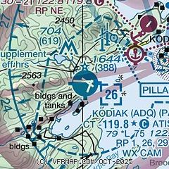
|
 Download PDF
of official airport diagram from the FAA
| Airport distance calculator |
|---|
|
|
| Sunrise and sunset |
|---|
|
Times for 06-Feb-2025
| | Local
(UTC-9) | | Zulu
(UTC) |
|---|
| Morning civil twilight | | 08:20 | | 17:20 |
| Sunrise | | 09:02 | | 18:02 |
| Sunset | | 17:46 | | 02:46 |
| Evening civil twilight | | 18:29 | | 03:29 |
|
| Current date and time |
|---|
| Zulu (UTC) | 07-Feb-2025 02:39:27 |
|---|
| Local (UTC-9) | 06-Feb-2025 17:39:27 |
|---|
|
| METAR |
|---|
| PADQ | 070153Z 31010KT 10SM CLR 05/M05 A3013 RMK AO2 SLP202 T00501050
|
|
| TAF |
|---|
| PADQ | 061735Z 0618/0718 30008KT P6SM SCT150
|
|
| NOTAMs |
|---|
NOTAMs are issued by the DoD/FAA and will open in a separate window not controlled by AirNav.
|
|


