FAA INFORMATION EFFECTIVE 23 JANUARY 2025
Location
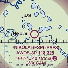
| FAA Identifier: | FSP |
| Lat/Long: | 63-01-06.8120N 154-21-30.3770W
63-01.113533N 154-21.506283W
63.0185589,-154.3584381
(estimated) |
| Elevation: | 447.3 ft. / 136.3 m (surveyed) |
| Variation: | 14E (2020) |
| From city: | 1 mile NE of NIKOLAI, AK |
| Time zone: | UTC -9 (UTC -8 during Daylight Saving Time) |
| Zip code: | 99691 |
Airport Operations
| Airport use: | Open to the public |
| Control tower: | no |
| ARTCC: | ANCHORAGE CENTER |
| FSS: | KENAI FLIGHT SERVICE STATION [907-283-7211] |
| NOTAMs facility: | FSP (NOTAM-D service available) |
| Attendance: | UNATNDD |
| Wind indicator: | lighted |
| Segmented circle: | yes
BRUSH GROWING INSIDE OF SEGMENTED CIRCLE. |
| Lights: | ACTVT REIL RWY 05, 23; PAPI RWY 05, 23; MIRL RWY 05/23 - CTAF. |
| Beacon: | white-green (lighted land airport)
ACVT ROTG BCN - CTAF. |
Airport Communications
| CTAF: | 122.8 |
| WX AWOS-3P: | 118.325 (907-293-2002) |
- APCH/DEP SVC PRVDD BY ANCHORAGE ARTCC ON FREQS 128.1/353.8 (MC GRATH RCAG).
Nearby radio navigation aids
| VOR radial/distance | | VOR name | | Freq | | Var |
|---|
| MCGr064/34.4 | | MC GRATH VORTAC | | 115.50 | | 19E |
| NDB name | | Hdg/Dist | | Freq | | Var | | ID |
|---|
| TAKOTNA RIVER | | 066/33.0 | | 350 | | 16E | | VTR | ...- - .-. |
Airport Services
| Airframe service: | NONE |
| Powerplant service: | NONE |
| Bottled oxygen: | NONE |
| Bulk oxygen: | NONE |
Runway Information
Runway 5/23
| Dimensions: | 4001 x 75 ft. / 1220 x 23 m |
| Surface: | gravel, in good condition |
| Runway edge lights: | medium intensity
MULTIPLE RWY LGTS BROKEN LENGTH OF RWY. BRUSH AND GRASS OBSURING SOME LGTS. |
| RUNWAY 5 | | RUNWAY 23 |
| Latitude: | 63-00.966175N | | 63-01.260843N |
| Longitude: | 154-22.151878W | | 154-20.860590W |
| Elevation: | 445.4 ft. | | 447.2 ft. |
| Traffic pattern: | left | | left |
| Runway heading: | 049 magnetic, 063 true | | 229 magnetic, 243 true |
| Markings: | none, in fair condition | | none, in fair condition |
| Visual slope indicator: | 4-light PAPI on left (3.20 degrees glide path) | | 4-light PAPI on left (3.20 degrees glide path) |
| Runway end identifier lights: | yes | | yes |
| Touchdown point: | yes, no lights | | yes, no lights |
| Obstructions: | 10 ft. brush, 139 ft. left of centerline | | 10 ft. brush, 12 ft. from runway, 92 ft. left of centerline, 1:1 slope to clear |
Airport Ownership and Management from official FAA records
| Ownership: | Publicly-owned |
| Owner: | ALASKA DOT&PF CENTRAL REGION
PO BOX 196900
ANCHORAGE, AK 99519-6900
Phone 907-269-0782 |
| Manager: | STEFFEN STRICK
PO BOX 21
MCGRATH, AK 99627
Phone 907-524-3241 |
Additional Remarks
| - | RWY CONDITION NOT MONITORED; RECOMMEND VISUAL INSPECTION PRIOR TO LANDING. |
| - | WX CAMERA AVBL ON INTERNET AT HTTPS://WEATHERCAMS.FAA.GOV. |
Instrument Procedures
NOTE: All procedures below are presented as PDF files. If you need a reader for these files, you should download the free Adobe Reader.NOT FOR NAVIGATION. Please procure official charts for flight.
FAA instrument procedures published for use from 23 January 2025 at 0901Z to 20 February 2025 at 0900z.
IAPs - Instrument Approach Procedures |
|---|
| RNAV (GPS) RWY 05 | |
download (204KB) |
| RNAV (GPS) RWY 23 | |
download (208KB) |
| NOTE: Special Take-Off Minimums/Departure Procedures apply | |
download (253KB) |
Other nearby airports with instrument procedures:
PAMC - Mc Grath Airport (34 nm W)
PATL - Tatalina LRRS Airport (45 nm W)
PAMH - Minchumina Airport (76 nm NE)
|
|

Road maps at:
MapQuest
Bing
Google
| Aerial photo |
|---|
WARNING: Photo may not be current or correct
 Photo by Tony Fernando
Photo taken 13-Nov-2007
from 10,000 feet
Photo by Tony Fernando
Photo taken 13-Nov-2007
from 10,000 feet
Do you have a better or more recent aerial photo of Nikolai Airport that you would like to share? If so, please send us your photo.
|
| Sectional chart |
|---|
|
| Airport distance calculator |
|---|
|
|
| Sunrise and sunset |
|---|
|
Times for 29-Jan-2025
| | Local
(UTC-9) | | Zulu
(UTC) |
|---|
| Morning civil twilight | | 09:03 | | 18:03 |
| Sunrise | | 09:59 | | 18:59 |
| Sunset | | 17:03 | | 02:03 |
| Evening civil twilight | | 17:58 | | 02:58 |
|
| Current date and time |
|---|
| Zulu (UTC) | 30-Jan-2025 01:48:34 |
|---|
| Local (UTC-9) | 29-Jan-2025 16:48:34 |
|---|
|
| METAR |
|---|
| PAFS | 300101Z AUTO 29006KT 10SM CLR M24/M28 A3045 RMK AO2 SLP331 T12391283 FZRANO
|
|
| TAF |
|---|
PAMC
34nm W | 291738Z 2918/3018 VRB01KT P6SM FEW025 BKN050
|
|
| NOTAMs |
|---|
NOTAMs are issued by the DoD/FAA and will open in a separate window not controlled by AirNav.
|
|


