FAA INFORMATION EFFECTIVE 23 JANUARY 2025
Location
| FAA Identifier: | 5NN |
| Lat/Long: | 59-58-48.8290N 154-50-21.0290W
59-58.813817N 154-50.350483W
59.9802303,-154.8391747
(estimated) |
| Elevation: | 314 ft. / 96 m (estimated) |
| Variation: | 14E (2020) |
| From city: | 1 mile NNE of NONDALTON, AK |
| Time zone: | UTC -9 (UTC -8 during Daylight Saving Time) |
Airport Operations
| Airport use: | Open to the public |
| Activation date: | 07/1962 |
| Control tower: | no |
| ARTCC: | ANCHORAGE CENTER |
| FSS: | ILIAMNA FLIGHT SERVICE STATION [907-571-1240] |
| Alternate FSS: | ENA KENAI FLIGHT SERVICE STATION [1-866-864-1737] |
| NOTAMs facility: | ILI (NOTAM-D service available) |
| Attendance: | UNATNDD |
| Wind indicator: | lighted |
| Segmented circle: | yes |
| Lights: | ACTVT MIRL RY 02/20; PAPI & REIL RYS 02 & 20; WINDSOCK LGTS - CTAF. |
| Beacon: | white-green (lighted land airport)
ACTVT ROTG BCN - CTAF. |
Airport Communications
| CTAF: | 122.9 |
| WX ASOS at ILI (14 nm S): | 134.95 (907-571-1483) |
- APCH/DEP SVC PRVDD BY ANCHORAGE ARTCC ON FREQ 118.8 (ILIAMNA RCAG).
- COMMUNICATIONS PRVDD BY KENAI FSS ON FREQ 122.2 (ILIAMNA RCO).
Nearby radio navigation aids
| NDB name | | Hdg/Dist | | Freq | | Var | | ID |
|---|
| ILIAMNA | | 355/14.1 | | 411 | | 14E | | ILI | .. .-.. .. |
Airport Services
| Parking: | tiedowns |
| Airframe service: | NONE |
| Powerplant service: | NONE |
| Bottled oxygen: | NONE |
| Bulk oxygen: | NONE |
Runway Information
Runway 2/20
| Dimensions: | 2800 x 75 ft. / 853 x 23 m |
| Surface: | gravel, in good condition |
| Runway edge lights: | medium intensity
RY 02/20 EDGE LGTS WHITE FULL LENGTH OF RY. |
| Runway edge markings: | RY 02/20 EDGE MARKED WITH REFLECTIVE CONES. THLDS MARKED WITH REFLECTIVE CONES AND THLD PANELS. |
| RUNWAY 2 | | RUNWAY 20 |
| Latitude: | 59-58.631833N | | 59-58.995783N |
| Longitude: | 154-50.630633W | | 154-50.070350W |
| Elevation: | 304.8 ft. | | 313.5 ft. |
| Traffic pattern: | right | | left |
| Runway heading: | 024 magnetic, 038 true | | 204 magnetic, 218 true |
| Markings: | NSTD | | NSTD |
| Visual slope indicator: | 4-light PAPI on left (3.50 degrees glide path)
PAPI UNUSBL BYD 4 DEG L OF CNTRLN. | | 4-light PAPI on left (3.50 degrees glide path) |
| Runway end identifier lights: | yes | | yes |
| Touchdown point: | yes, no lights | | yes, no lights |
| Obstructions: | 18 ft. brush, 248 ft. left of centerline | | 5 ft. brush, 95 ft. right of centerline |
Airport Ownership and Management from official FAA records
| Ownership: | Publicly-owned |
| Owner: | ALASKA DOT&PF SOUTHCOAST REGION
PO BOX 112506
JUNEAU, AK 99811-2506
Phone 907-465-1779 |
| Manager: | TREFIM ANDREW
PO BOX 187
ILIAMMA 99606
Phone 907-571-1261 |
Additional Remarks
| - | RY COND NOT MONITORED; RCMD VISUAL INSPECTION PRIOR TO USING. |
| - | WX CAMERA AVBL ON INTERNET AT HTTPS://WEATHERCAMS.FAA.GOV |
| - | STRONG AND VARIABLE CROSSWINDS AT OR NEAR THE RWY SFC. |
| - | WATER TANK, 55 AGL/431 AMSL, LOCATED 2,129 FEET FROM DEPARTURE END OF RUNWAY 20, 398 FEET RIGHT OF CENTERLINE; ANTENNA TOWER, 45 AGL/421 AMSL, LOCATED 2,032 FEET FROM DEPARTURE END OF RUNWAY 20, 420 FEET RIGHT OF CENTERLINE. |
| - | COLD TEMPERATURE AIRPORT. ALTITUDE CORRECTION REQUIRED AT OR BELOW -13C. |
Instrument Procedures
NOTE: All procedures below are presented as PDF files. If you need a reader for these files, you should download the free Adobe Reader.NOT FOR NAVIGATION. Please procure official charts for flight.
FAA instrument procedures published for use from 23 January 2025 at 0901Z to 20 February 2025 at 0900z.
IAPs - Instrument Approach Procedures |
|---|
| RNAV (GPS) RWY 02 | |
download (301KB) |
|
|---|
| DUMZU ONE (OBSTACLE) (RNAV) | |
download (339KB) |
| NOTE: Special Take-Off Minimums/Departure Procedures apply | |
download (397KB) |
Other nearby airports with instrument procedures:
PAIL - Iliamna Airport (14 nm S)
PAKX - Wilder Runway Airport (20 nm NE)
PFKK - Kokhanok Airport (33 nm S)
PAIG - Igiugig Airport (51 nm SW)
PASV - Sparrevohn LRRS Airport (70 nm N)
|
|

Road maps at:
MapQuest
Bing
Google
| Aerial photo |
|---|
WARNING: Photo may not be current or correct
 Photo by LL
Photo taken 19-Jun-2013
looking southwest.
Photo by LL
Photo taken 19-Jun-2013
looking southwest.
Do you have a better or more recent aerial photo of Nondalton Airport that you would like to share? If so, please send us your photo.
|
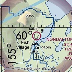
| Sectional chart |
|---|
|
| Airport distance calculator |
|---|
|
|
| Sunrise and sunset |
|---|
|
Times for 06-Feb-2025
| | Local
(UTC-9) | | Zulu
(UTC) |
|---|
| Morning civil twilight | | 08:35 | | 17:35 |
| Sunrise | | 09:21 | | 18:21 |
| Sunset | | 17:46 | | 02:46 |
| Evening civil twilight | | 18:32 | | 03:32 |
|
| Current date and time |
|---|
| Zulu (UTC) | 07-Feb-2025 03:04:50 |
|---|
| Local (UTC-9) | 06-Feb-2025 18:04:50 |
|---|
|
| METAR |
|---|
PAIL
14nm S | 070253Z 00000KT 1/4SM FZFG VV003 M08/M08 A3018 RMK AO2 SLP225 T10781083 56006
|
PAKX
20nm NE | 070255Z AUTO 13003KT 10SM M07/M08 A3015 RMK AO2
|
PALJ
21nm NE | 062352Z 00000KT 40SM SCT100 M03/M08 A3017 RMK EST PASS OPEN NOSPECI
|
|
| TAF |
|---|
PAIL
14nm S | 061725Z 0618/0718 VRB03KT P6SM SCT003 TEMPO 0618/0622 1/4SM FZFG VV003 FM070900 36006KT P6SM SKC
|
|
| NOTAMs |
|---|
NOTAMs are issued by the DoD/FAA and will open in a separate window not controlled by AirNav.
|
|


